Bourg-Saint-Andéol elevation
Bourg-Saint-Andéol (Auvergne-Rhône-Alpes, Département de l'Ardèche), France elevation is 52 meters and Bourg-Saint-Andéol elevation in feet is 171 ft above sea level [src 1]. Bourg-Saint-Andéol is a populated place (feature code) with elevation that is 122 meters (400 ft) smaller than average city elevation in France.
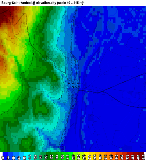
Below is the Elevation map of Bourg-Saint-Andéol, which displays elevation range with different colors. Scale of the first map is from 40 to 415 m (131 to 1362 ft) with average elevation of 110 meters (=361 ft) [note 1]
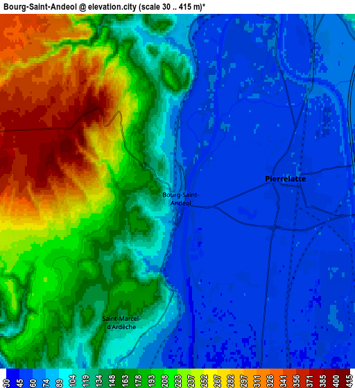
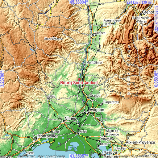
These maps also provides idea of topography and contour of this city, they are displayed at different zoom levels. More info about maps, scale and edge coordinates you can find below images.
| \ | Map #1 | Map #2 | Topo.Map |
| Scale [m] | 40..415 m | 30..415 m | × |
| Scale [ft] | 131..1362 ft | 98..1362 ft | × |
| Average | 110 m = 361 ft | 135.8 m = 446 ft | × |
| Width | 6.99 km = 4.3 mi | 13.97 km = 8.7 mi | 223.5 km = 138.9 mi |
| Height | 6.99 km = 4.3 mi | 13.97 km = 8.7 mi | 223.5 km = 138.9 mi |
| ↑Max Latitude | 44.404784° | 44.43617° | 45.36994° |
| Latitude at center | 44.37338° | 44.37338° | 44.37338° |
| ↓Min Latitude | 44.34196° | 44.310522° | 43.35957° |
| ← Min Longitude | 4.600185° | 4.556239° | 3.23788° |
| Longitude center | 4.64413° | 4.64413° | 4.64413° |
| →Max Longitude | 4.688075° | 4.732021° | 6.05038° |
Nearby cities:
Cities around Bourg-Saint-Andéol sort by population:
• Bollène elevation 64 m
13.2 km,  140°
140°
• Pierrelatte 55 m
4.7 km,  87°
87°
• Saint-Paul-Trois-Châteaux 98 m
10 km,  107°
107°
• Donzère 115 m
9.4 km,  34°
34°
• Viviers 60 m
12.7 km,  16°
16°
• Lapalud 45 m
8.1 km,  153°
153°
• Saint-Marcel-d'Ardèche 137 m
5.5 km,  202°
202°
• Saint-Paulet-de-Caisson 84 m
13.1 km, 196°
• Saint-Restitut 75 m
13 km, 114°
• Saint-Just-d'Ardèche 60 m
8.4 km,  194°
194°
• Saint-Julien-de-Peyrolas 106 m
11.4 km,  213°
213°
• La Garde-Adhémar 170 m
9.4 km,  73°
73°
Multilingual:
 En español:
Bourg-Saint-Andéol elevación 52 m.
 En France:
Bourg-Saint-Andéol élévation 52 m.
 Auf Deutsch:
Bourg-Saint-Andéol höhe über dem Meeresspiegel ist 52 m.

Sources and notes:
- [note 1] Map square and city borders are not equal. Map elevation data is calculated only from area inside that square.
- [src 1] Elevation data from geonames database provided with same terms of usage.
- [src 2] The elevation map of Bourg-Saint-Andéol is generated using elevation data from NASA's 3 arcsec (90m) resolution SRTM data.
- [src 3] Base (background) map © OpenStreetMap contributors tiles are generated by Geofabrik and OpenTopoMap.
Copyright & License:
This Bourg-Saint-Andéol Elevation Map is licensed under CC BY-SA. You may reuse any part from this page, if you give a proper credit by linking to this URL:
 More info on terms of use page.