Châteauneuf-du-Rhône elevation
Châteauneuf-du-Rhône (Auvergne-Rhône-Alpes, Département de la Drôme), France elevation is 113 meters and Châteauneuf-du-Rhône elevation in feet is 371 ft above sea level [src 1]. Châteauneuf-du-Rhône is a populated place (feature code) with elevation that is 61 meters (200 ft) smaller than average city elevation in France.
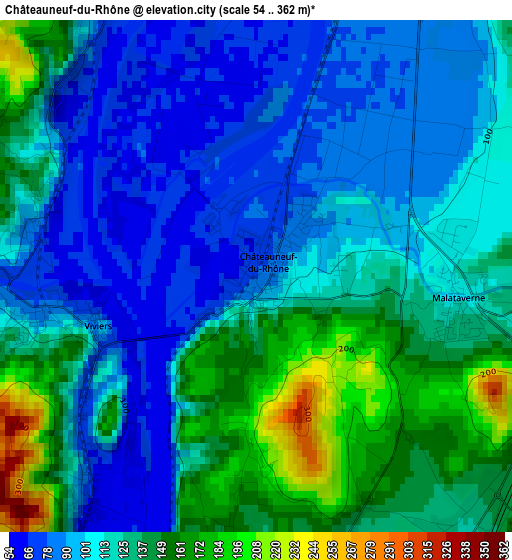
Below is the Elevation map of Châteauneuf-du-Rhône, which displays elevation range with different colors. Scale of the first map is from 54 to 362 m (177 to 1188 ft) with average elevation of 117.9 meters (=387 ft) [note 1]
These maps also provides idea of topography and contour of this city, they are displayed at different zoom levels. More info about maps, scale and edge coordinates you can find below images.
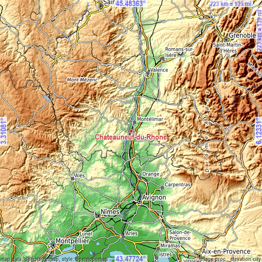
| \ | Map #1 | Topo.Map |
| Scale [m] | 54..362 m | × |
| Scale [ft] | 177..1188 ft | × |
| Average | 117.9 m = 387 ft | × |
| Width | 6.97 km = 4.3 mi | 223.1 km = 138.6 mi |
| Height | 6.97 km = 4.3 mi | 223.1 km = 138.6 mi |
| ↑Max Latitude | 44.520401° | 45.48363° |
| Latitude at center | 44.48906° | 44.48906° |
| ↓Min Latitude | 44.457702° | 43.47724° |
| ← Min Longitude | 4.673115° | 3.31081° |
| Longitude center | 4.71706° | 4.71706° |
| →Max Longitude | 4.761005° | 6.12331° |
Nearby cities:
Cities around Châteauneuf-du-Rhône sort by population:
• Montélimar elevation 86 m
7.9 km,  22°
22°
• Pierrelatte 55 m
12.7 km,  185°
185°
• Le Teil 67 m
6.8 km,  336°
336°
• Donzère 115 m
5.2 km, 185°
• Viviers 60 m
2.3 km,  252°
252°
• Rochemaure 74 m
11 km,  354°
354°
• Montboucher-sur-Jabron 125 m
9.6 km,  44°
44°
• Allan 192 m
5.9 km,  81°
81°
• Malataverne 128 m
2.9 km,  98°
98°
• Alba-la-Romaine 211 m
11.9 km,  308°
308°
• La Garde-Adhémar 170 m
10.7 km,  162°
162°
• Ancône 73 m
10.3 km,  4°
4°
Multilingual:
 En español:
Châteauneuf-du-Rhône elevación 113 m.
 En France:
Châteauneuf-du-Rhône élévation 113 m.
 Auf Deutsch:
Châteauneuf-du-Rhône höhe über dem Meeresspiegel ist 113 m.
 На русском:
Châteauneuf-du-Rhône высота над уровнем моря 113 м
Sources and notes:
- [note 1] Map square and city borders are not equal. Map elevation data is calculated only from area inside that square.
- [src 1] Elevation data from geonames database provided with same terms of usage.
- [src 2] The elevation map of Châteauneuf-du-Rhône is generated using elevation data from NASA's 3 arcsec (90m) resolution SRTM data.
- [src 3] Base (background) map © OpenStreetMap contributors tiles are generated by Geofabrik and OpenTopoMap.
Copyright & License:
This Châteauneuf-du-Rhône Elevation Map is licensed under CC BY-SA. You may reuse any part from this page, if you give a proper credit by linking to this URL:
 More info on terms of use page.