Esternay elevation
Esternay (Grand Est, Marne), France elevation is 158 meters and Esternay elevation in feet is 518 ft above sea level [src 1]. Esternay is a populated place (feature code) with elevation that is 16 meters (52 ft) smaller than average city elevation in France.
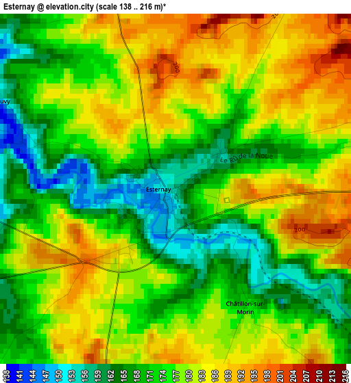
Below is the Elevation map of Esternay, which displays elevation range with different colors. Scale of the first map is from 138 to 216 m (453 to 709 ft) with average elevation of 176.3 meters (=578 ft) [note 1]
These maps also provides idea of topography and contour of this city, they are displayed at different zoom levels. More info about maps, scale and edge coordinates you can find below images.
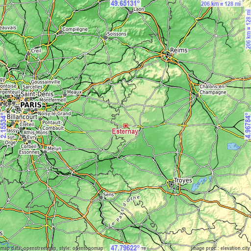
| \ | Map #1 | Topo.Map |
| Scale [m] | 138..216 m | × |
| Scale [ft] | 453..709 ft | × |
| Average | 176.3 m = 578 ft | × |
| Width | 6.45 km = 4 mi | 206.3 km = 128.2 mi |
| Height | 6.45 km = 4 mi | 206.3 km = 128.2 mi |
| ↑Max Latitude | 48.761297° | 49.65131° |
| Latitude at center | 48.73232° | 48.73232° |
| ↓Min Latitude | 48.703326° | 47.79622° |
| ← Min Longitude | 3.517645° | 2.15534° |
| Longitude center | 3.56159° | 3.56159° |
| →Max Longitude | 3.605535° | 4.96784° |
Nearby cities:
Cities around Esternay sort by population:
• Nogent-sur-Seine elevation 75 m
26.9 km,  189°
189°
• Sézanne 130 m
11.9 km,  96°
96°
• La Ferté-Gaucher 119 m
19.5 km,  286°
286°
• Montmirail 190 m
15.6 km,  353°
353°
• Villenauxe-la-Grande 74 m
16.6 km,  182°
182°
• Jouy-sur-Morin 115 m
22.3 km, 288°
• Sourdun 150 m
26.6 km,  215°
215°
• Saint-Just-Sauvage 74 m
25.6 km,  140°
140°
• Choisy-en-Brie 144 m
25.4 km,  276°
276°
• Villeneuve-sur-Bellot 90 m
21.6 km,  311°
311°
• Connantre 97 m
26.6 km,  91°
91°
• Villiers-Saint-Georges 157 m
14.5 km,  231°
231°
Multilingual:
 En español:
Esternay elevación 158 m.
 En France:
Esternay élévation 158 m.
 Auf Deutsch:
Esternay höhe über dem Meeresspiegel ist 158 m.

Sources and notes:
- [note 1] Map square and city borders are not equal. Map elevation data is calculated only from area inside that square.
- [src 1] Elevation data from geonames database provided with same terms of usage.
- [src 2] The elevation map of Esternay is generated using elevation data from NASA's 3 arcsec (90m) resolution SRTM data.
- [src 3] Base (background) map © OpenStreetMap contributors tiles are generated by Geofabrik and OpenTopoMap.
Copyright & License:
This Esternay Elevation Map is licensed under CC BY-SA. You may reuse any part from this page, if you give a proper credit by linking to this URL:
 More info on terms of use page.