Etaux elevation
Etaux (Auvergne-Rhône-Alpes, Haute-Savoie), France elevation is 570 meters and Etaux elevation in feet is 1870 ft above sea level [src 1]. Etaux is a populated place (feature code) with elevation that is 396 meters (1299 ft) bigger than average city elevation in France.
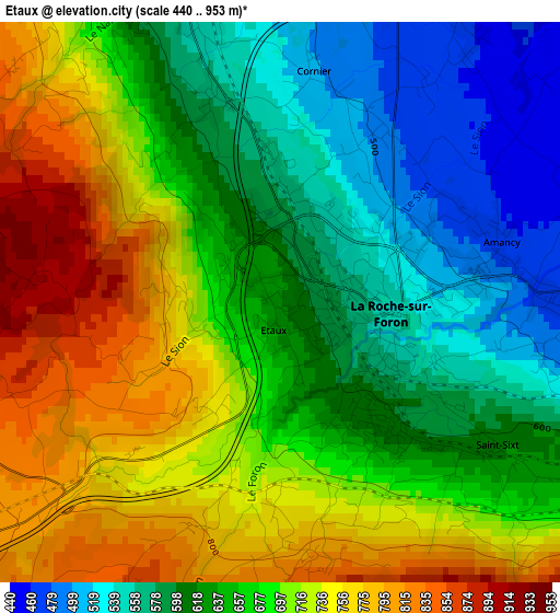
Below is the Elevation map of Etaux, which displays elevation range with different colors. Scale of the first map is from 440 to 953 m (1444 to 3127 ft) with average elevation of 667.1 meters (=2189 ft) [note 1]
These maps also provides idea of topography and contour of this city, they are displayed at different zoom levels. More info about maps, scale and edge coordinates you can find below images.
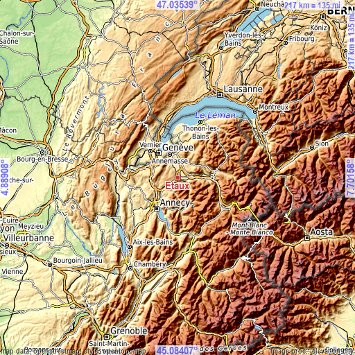
| \ | Map #1 | Topo.Map |
| Scale [m] | 440..953 m | × |
| Scale [ft] | 1444..3127 ft | × |
| Average | 667.1 m = 2189 ft | × |
| Width | 6.78 km = 4.2 mi | 217 km = 134.8 mi |
| Height | 6.78 km = 4.2 mi | 217 km = 134.8 mi |
| ↑Max Latitude | 46.098831° | 47.03539° |
| Latitude at center | 46.06835° | 46.06835° |
| ↓Min Latitude | 46.037852° | 45.08407° |
| ← Min Longitude | 6.251385° | 4.88908° |
| Longitude center | 6.29533° | 6.29533° |
| →Max Longitude | 6.339275° | 7.70158° |
Nearby cities:
Cities around Etaux sort by population:
• Bonneville elevation 450 m
8.7 km,  81°
81°
• La Roche-sur-Foron 540 m
0.8 km,  66°
66°
• Reignier-Ésery 484 m
7.6 km,  342°
342°
• Thorens-Glières 659 m
9 km,  205°
205°
• Pers-Jussy 558 m
4.6 km,  334°
334°
• Amancy 465 m
2.6 km, 78°
• Contamine-sur-Arve 526 m
8.7 km,  19°
19°
• Évires 827 m
6.4 km,  238°
238°
• Arthaz-Pont-Notre-Dame 478 m
10.4 km,  347°
347°
• Arenthon 438 m
5.2 km,  34°
34°
• Peillonnex 640 m
9.2 km,  43°
43°
• Cornier 490 m
2.8 km,  5°
5°
Multilingual:
 En español:
Etaux elevación 570 m.
 En France:
Etaux, Étaux élévation 570 m.


Sources and notes:
- [note 1] Map square and city borders are not equal. Map elevation data is calculated only from area inside that square.
- [src 1] Elevation data from geonames database provided with same terms of usage.
- [src 2] The elevation map of Etaux is generated using elevation data from NASA's 3 arcsec (90m) resolution SRTM data.
- [src 3] Base (background) map © OpenStreetMap contributors tiles are generated by Geofabrik and OpenTopoMap.
Copyright & License:
This Etaux Elevation Map is licensed under CC BY-SA. You may reuse any part from this page, if you give a proper credit by linking to this URL:
 More info on terms of use page.