Thorens-Glières elevation
Thorens-Glières (Auvergne-Rhône-Alpes, Haute-Savoie), France elevation is 659 meters and Thorens-Glières elevation in feet is 2162 ft above sea level [src 1]. Thorens-Glières is a populated place (feature code) with elevation that is 485 meters (1591 ft) bigger than average city elevation in France.
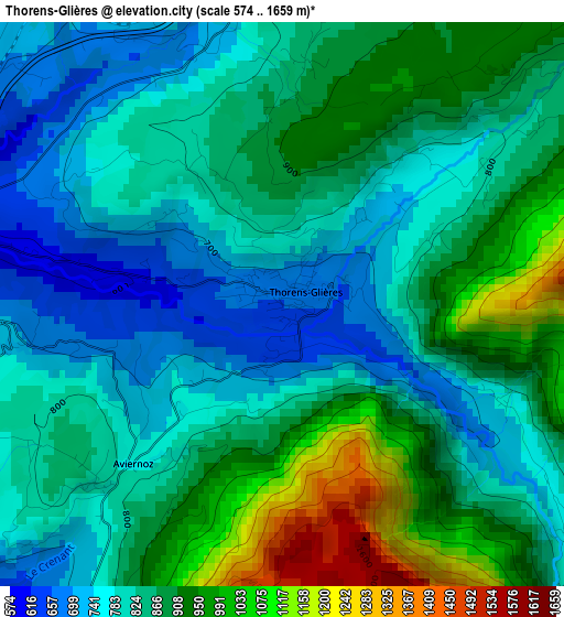
Below is the Elevation map of Thorens-Glières, which displays elevation range with different colors. Scale of the first map is from 574 to 1659 m (1883 to 5443 ft) with average elevation of 853.3 meters (=2800 ft) [note 1]
These maps also provides idea of topography and contour of this city, they are displayed at different zoom levels. More info about maps, scale and edge coordinates you can find below images.
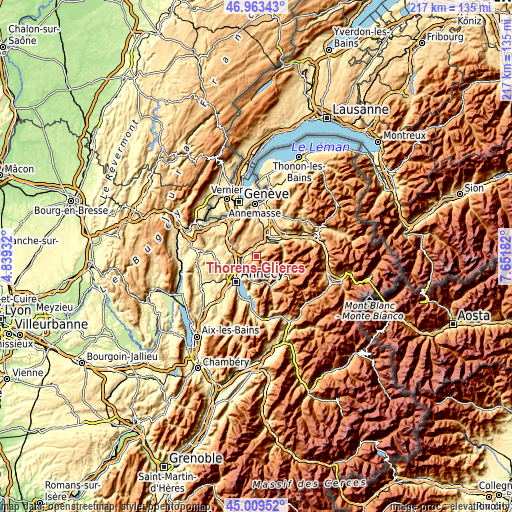
| \ | Map #1 | Topo.Map |
| Scale [m] | 574..1659 m | × |
| Scale [ft] | 1883..5443 ft | × |
| Average | 853.3 m = 2800 ft | × |
| Width | 6.79 km = 4.2 mi | 217.3 km = 135 mi |
| Height | 6.79 km = 4.2 mi | 217.2 km = 135 mi |
| ↑Max Latitude | 46.025621° | 46.96343° |
| Latitude at center | 45.9951° | 45.9951° |
| ↓Min Latitude | 45.964562° | 45.00952° |
| ← Min Longitude | 6.201625° | 4.83932° |
| Longitude center | 6.24557° | 6.24557° |
| →Max Longitude | 6.289515° | 7.65182° |
Nearby cities:
Cities around Thorens-Glières sort by population:
• Annecy-le-Vieux elevation 498 m
11.5 km,  223°
223°
• La Roche-sur-Foron 540 m
9.6 km,  28°
28°
• Cruseilles 810 m
11.3 km,  290°
290°
• Groisy 649 m
6.1 km, 285°
• Pringy 508 m
10.7 km,  239°
239°
• Villaz 745 m
6.3 km, 219°
• Amancy 465 m
10.8 km,  36°
36°
• Saint-Martin-Bellevue 611 m
7.7 km, 242°
• Évires 827 m
5 km,  341°
341°
• Etaux 570 m
9 km, 25°
• Allonzier-la-Caille 648 m
9.8 km,  273°
273°
• Dingy-Saint-Clair 658 m
10 km,  188°
188°
Multilingual:
 En español:
Thorens-Glières elevación 659 m.
 En France:
Thorens-Glières élévation 659 m.
 Auf Deutsch:
Thorens-Glières höhe über dem Meeresspiegel ist 659 m.

Sources and notes:
- [note 1] Map square and city borders are not equal. Map elevation data is calculated only from area inside that square.
- [src 1] Elevation data from geonames database provided with same terms of usage.
- [src 2] The elevation map of Thorens-Glières is generated using elevation data from NASA's 3 arcsec (90m) resolution SRTM data.
- [src 3] Base (background) map © OpenStreetMap contributors tiles are generated by Geofabrik and OpenTopoMap.
Copyright & License:
This Thorens-Glières Elevation Map is licensed under CC BY-SA. You may reuse any part from this page, if you give a proper credit by linking to this URL:
 More info on terms of use page.