La Roche-sur-Foron elevation
La Roche-sur-Foron (Auvergne-Rhône-Alpes, Haute-Savoie), France elevation is 540 meters and La Roche-sur-Foron elevation in feet is 1772 ft above sea level [src 1]. La Roche-sur-Foron is a populated place (feature code) with elevation that is 366 meters (1201 ft) bigger than average city elevation in France.
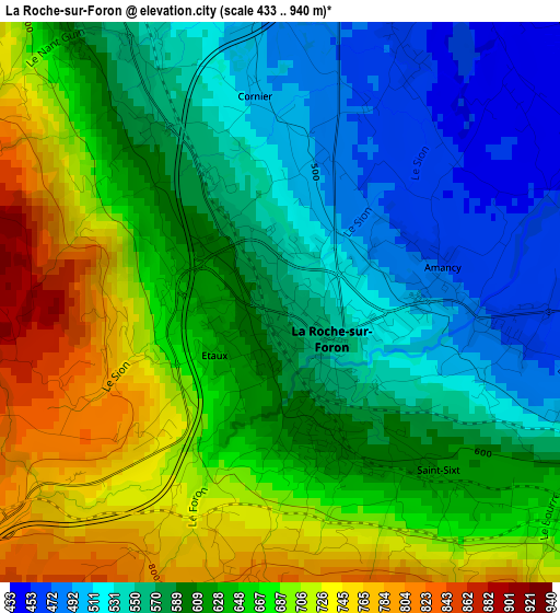
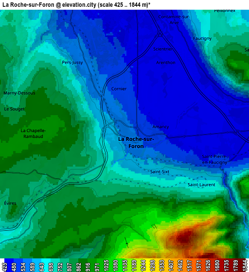
Below is the Elevation map of La Roche-sur-Foron, which displays elevation range with different colors. Scale of the first map is from 433 to 940 m (1421 to 3084 ft) with average elevation of 619.4 meters (=2032 ft) [note 1]
These maps also provides idea of topography and contour of this city, they are displayed at different zoom levels. More info about maps, scale and edge coordinates you can find below images.
| \ | Map #1 | Map #2 | Topo.Map |
| Scale [m] | 433..940 m | 425..1844 m | × |
| Scale [ft] | 1421..3084 ft | 1394..6050 ft | × |
| Average | 619.4 m = 2032 ft | 723.6 m = 2374 ft | × |
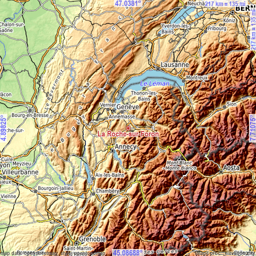
| Width | 6.78 km = 4.2 mi | 13.56 km = 8.4 mi | 217 km = 134.8 mi |
| Height | 6.78 km = 4.2 mi | 13.56 km = 8.4 mi | 216.9 km = 134.8 mi |
| ↑Max Latitude | 46.101589° | 46.132052° | 47.0381° |
| Latitude at center | 46.07111° | 46.07111° | 46.07111° |
| ↓Min Latitude | 46.040614° | 46.010101° | 45.08688° |
| ← Min Longitude | 6.260555° | 6.216609° | 4.89825° |
| Longitude center | 6.3045° | 6.3045° | 6.3045° |
| →Max Longitude | 6.348445° | 6.392391° | 7.71075° |
Nearby cities:
Cities around La Roche-sur-Foron sort by population:
• Bonneville elevation 450 m
8 km,  82°
82°
• Reignier-Ésery 484 m
7.5 km,  337°
337°
• Thorens-Glières 659 m
9.6 km,  208°
208°
• Fillinges 573 m
10.2 km,  16°
16°
• Pers-Jussy 558 m
4.7 km,  325°
325°
• Amancy 465 m
1.9 km, 83°
• Contamine-sur-Arve 526 m
8.2 km, 15°
• Évires 827 m
7.2 km,  239°
239°
• Arenthon 438 m
4.6 km,  28°
28°
• Etaux 570 m
0.8 km,  246°
246°
• Peillonnex 640 m
8.5 km,  41°
41°
• Cornier 490 m
2.5 km,  350°
350°
Multilingual:
 En español:
La Roche-sur-Foron elevación 540 m.
 En France:
La Roche-sur-Foron élévation 540 m.
 Auf Deutsch:
La Roche-sur-Foron höhe über dem Meeresspiegel ist 540 m.
 На русском:
La Roche-sur-Foron высота над уровнем моря 540 м
Sources and notes:
- [note 1] Map square and city borders are not equal. Map elevation data is calculated only from area inside that square.
- [src 1] Elevation data from geonames database provided with same terms of usage.
- [src 2] The elevation map of La Roche-sur-Foron is generated using elevation data from NASA's 3 arcsec (90m) resolution SRTM data.
- [src 3] Base (background) map © OpenStreetMap contributors tiles are generated by Geofabrik and OpenTopoMap.
Copyright & License:
This La Roche-sur-Foron Elevation Map is licensed under CC BY-SA. You may reuse any part from this page, if you give a proper credit by linking to this URL:
 More info on terms of use page.