Étrelles elevation
Étrelles (Brittany, Département d'Ille-et-Vilaine), France elevation is 92 meters and Étrelles elevation in feet is 302 ft above sea level [src 1]. Étrelles is a populated place (feature code) with elevation that is 82 meters (269 ft) smaller than average city elevation in France.
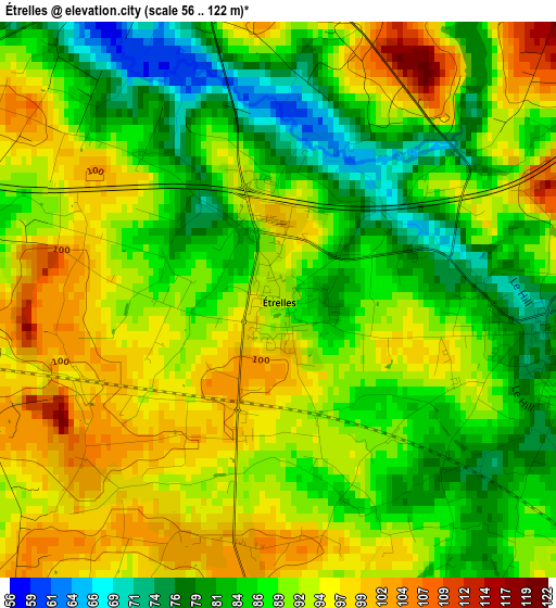
Below is the Elevation map of Étrelles, which displays elevation range with different colors. Scale of the first map is from 56 to 122 m (184 to 400 ft) with average elevation of 89.8 meters (=295 ft) [note 1]
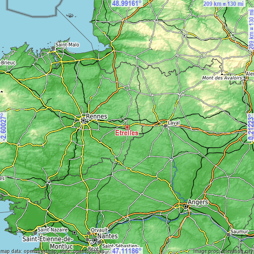
These maps also provides idea of topography and contour of this city, they are displayed at different zoom levels. More info about maps, scale and edge coordinates you can find below images.
| \ | Map #1 | Topo.Map |
| Scale [m] | 56..122 m | × |
| Scale [ft] | 184..400 ft | × |
| Average | 89.8 m = 295 ft | × |
| Width | 6.53 km = 4.1 mi | 209 km = 129.9 mi |
| Height | 6.53 km = 4.1 mi | 209 km = 129.9 mi |
| ↑Max Latitude | 48.089672° | 48.99161° |
| Latitude at center | 48.06031° | 48.06031° |
| ↓Min Latitude | 48.030931° | 47.11186° |
| ← Min Longitude | -1.237965° | -2.60027° |
| Longitude center | -1.19402° | -1.19402° |
| →Max Longitude | -1.150075° | 0.21223° |
Nearby cities:
Cities around Étrelles sort by population:
• Vitré elevation 115 m
6.4 km,  352°
352°
• La Guerche-de-Bretagne 75 m
13.5 km,  191°
191°
• Argentré-du-Plessis 101 m
3.6 km,  95°
95°
• Bais 73 m
9.1 km,  231°
231°
• Balazé 89 m
12 km,  0°
0°
• Erbrée 120 m
6.6 km,  51°
51°
• Domalain 96 m
8 km,  206°
206°
• Louvigné-de-Bais 86 m
10.3 km,  262°
262°
• Le Pertre 165 m
12 km, 104°
• Pocé-les-Bois 87 m
7.6 km,  325°
325°
• Montreuil-sous-Pérouse 82 m
10.7 km,  341°
341°
• Torcé 92 m
5.4 km,  271°
271°
Multilingual:
 En español:
Étrelles elevación 92 m.
 En France:
Étrelles élévation 92 m.


Sources and notes:
- [note 1] Map square and city borders are not equal. Map elevation data is calculated only from area inside that square.
- [src 1] Elevation data from geonames database provided with same terms of usage.
- [src 2] The elevation map of Étrelles is generated using elevation data from NASA's 3 arcsec (90m) resolution SRTM data.
- [src 3] Base (background) map © OpenStreetMap contributors tiles are generated by Geofabrik and OpenTopoMap.
Copyright & License:
This Étrelles Elevation Map is licensed under CC BY-SA. You may reuse any part from this page, if you give a proper credit by linking to this URL:
 More info on terms of use page.