La Guerche-de-Bretagne elevation
La Guerche-de-Bretagne (Brittany, Département d'Ille-et-Vilaine), France elevation is 75 meters and La Guerche-de-Bretagne elevation in feet is 246 ft above sea level [src 1]. La Guerche-de-Bretagne is a populated place (feature code) with elevation that is 99 meters (325 ft) smaller than average city elevation in France.
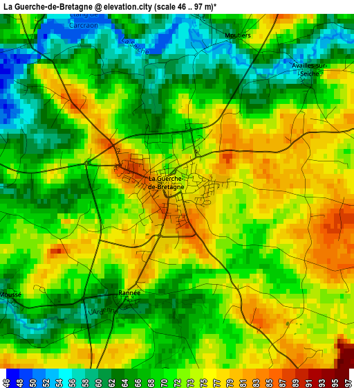
Below is the Elevation map of La Guerche-de-Bretagne, which displays elevation range with different colors. Scale of the first map is from 46 to 97 m (151 to 318 ft) with average elevation of 70.7 meters (=232 ft) [note 1]
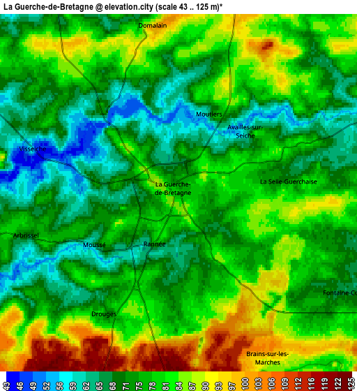
These maps also provides idea of topography and contour of this city, they are displayed at different zoom levels. More info about maps, scale and edge coordinates you can find below images.
| \ | Map #1 | Map #2 | Topo.Map |
| Scale [m] | 46..97 m | 43..125 m | × |
| Scale [ft] | 151..318 ft | 141..410 ft | × |
| Average | 70.7 m = 232 ft | 77 m = 253 ft | × |
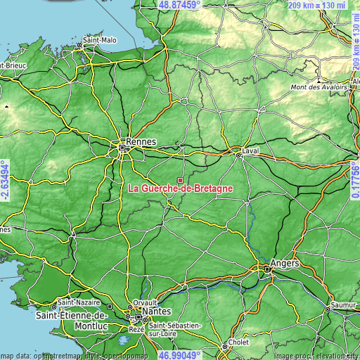
| Width | 6.55 km = 4.1 mi | 13.09 km = 8.1 mi | 209.5 km = 130.2 mi |
| Height | 6.55 km = 4.1 mi | 13.09 km = 8.1 mi | 209.5 km = 130.2 mi |
| ↑Max Latitude | 47.97055° | 47.999964° | 48.87459° |
| Latitude at center | 47.94112° | 47.94112° | 47.94112° |
| ↓Min Latitude | 47.911673° | 47.882209° | 46.99049° |
| ← Min Longitude | -1.272635° | -1.316581° | -2.63494° |
| Longitude center | -1.22869° | -1.22869° | -1.22869° |
| →Max Longitude | -1.184745° | -1.140799° | 0.17756° |
Nearby cities:
Cities around La Guerche-de-Bretagne sort by population:
• Argentré-du-Plessis elevation 101 m
14.3 km,  25°
25°
• Retiers 73 m
11.6 km,  254°
254°
• Martigné-Ferchaud 104 m
14.1 km,  208°
208°
• Étrelles 92 m
13.5 km,  11°
11°
• Bais 73 m
8.9 km,  329°
329°
• Piré-sur-Seiche 54 m
16.7 km,  297°
297°
• Domalain 96 m
6.2 km,  350°
350°
• Louvigné-de-Bais 86 m
14.2 km, 327°
• Le Theil-de-Bretagne 85 m
15.2 km,  260°
260°
• Rannée 75 m
2.1 km, 205°
• Ballots 79 m
14.4 km,  110°
110°
• Torcé 92 m
13.7 km, 347°
Multilingual:
 En español:
La Guerche-de-Bretagne elevación 75 m.
 En France:
La Guerche-de-Bretagne élévation 75 m.
 Auf Deutsch:
La Guerche-de-Bretagne höhe über dem Meeresspiegel ist 75 m.
 На русском:
La Guerche-de-Bretagne высота над уровнем моря 75 м
Sources and notes:
- [note 1] Map square and city borders are not equal. Map elevation data is calculated only from area inside that square.
- [src 1] Elevation data from geonames database provided with same terms of usage.
- [src 2] The elevation map of La Guerche-de-Bretagne is generated using elevation data from NASA's 3 arcsec (90m) resolution SRTM data.
- [src 3] Base (background) map © OpenStreetMap contributors tiles are generated by Geofabrik and OpenTopoMap.
Copyright & License:
This La Guerche-de-Bretagne Elevation Map is licensed under CC BY-SA. You may reuse any part from this page, if you give a proper credit by linking to this URL:
 More info on terms of use page.