Louvigné-de-Bais elevation
Louvigné-de-Bais (Brittany, Département d'Ille-et-Vilaine), France elevation is 86 meters and Louvigné-de-Bais elevation in feet is 282 ft above sea level [src 1]. Louvigné-de-Bais is a populated place (feature code) with elevation that is 88 meters (289 ft) smaller than average city elevation in France.
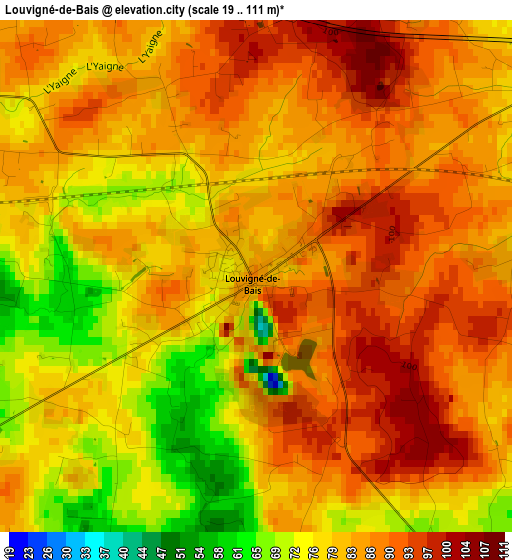
Below is the Elevation map of Louvigné-de-Bais, which displays elevation range with different colors. Scale of the first map is from 19 to 111 m (62 to 364 ft) with average elevation of 82.5 meters (=271 ft) [note 1]
These maps also provides idea of topography and contour of this city, they are displayed at different zoom levels. More info about maps, scale and edge coordinates you can find below images.
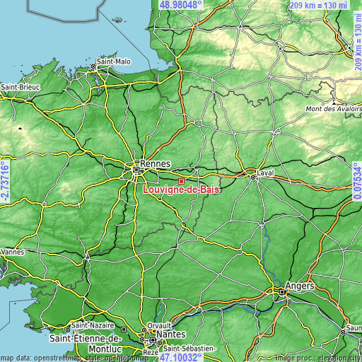
| \ | Map #1 | Topo.Map |
| Scale [m] | 19..111 m | × |
| Scale [ft] | 62..364 ft | × |
| Average | 82.5 m = 271 ft | × |
| Width | 6.53 km = 4.1 mi | 209.1 km = 129.9 mi |
| Height | 6.53 km = 4.1 mi | 209 km = 129.9 mi |
| ↑Max Latitude | 48.078349° | 48.98048° |
| Latitude at center | 48.04898° | 48.04898° |
| ↓Min Latitude | 48.019594° | 47.10032° |
| ← Min Longitude | -1.374855° | -2.73716° |
| Longitude center | -1.33091° | -1.33091° |
| →Max Longitude | -1.286965° | 0.07534° |
Nearby cities:
Cities around Louvigné-de-Bais sort by population:
• Vitré elevation 115 m
12 km,  50°
50°
• Châteaubourg 50 m
8.6 km,  323°
323°
• Étrelles 92 m
10.3 km,  82°
82°
• Bais 73 m
5.3 km,  145°
145°
• Piré-sur-Seiche 54 m
8.5 km,  239°
239°
• Domagné 81 m
5.2 km,  297°
297°
• Domalain 96 m
8.8 km,  131°
131°
• Amanlis 35 m
11.8 km,  246°
246°
• Saint-Didier 70 m
6 km,  328°
328°
• Pocé-les-Bois 87 m
9.5 km,  38°
38°
• Ossé 60 m
8.9 km,  274°
274°
• Torcé 92 m
4.9 km,  74°
74°
Multilingual:
 En español:
Louvigné-de-Bais elevación 86 m.
 En France:
Louvigné-de-Bais élévation 86 m.
 Auf Deutsch:
Louvigné-de-Bais höhe über dem Meeresspiegel ist 86 m.

Sources and notes:
- [note 1] Map square and city borders are not equal. Map elevation data is calculated only from area inside that square.
- [src 1] Elevation data from geonames database provided with same terms of usage.
- [src 2] The elevation map of Louvigné-de-Bais is generated using elevation data from NASA's 3 arcsec (90m) resolution SRTM data.
- [src 3] Base (background) map © OpenStreetMap contributors tiles are generated by Geofabrik and OpenTopoMap.
Copyright & License:
This Louvigné-de-Bais Elevation Map is licensed under CC BY-SA. You may reuse any part from this page, if you give a proper credit by linking to this URL:
 More info on terms of use page.