Étrépagny elevation
Étrépagny (Normandy, Département de l'Eure), France elevation is 86 meters and Étrépagny elevation in feet is 282 ft above sea level [src 1]. Étrépagny is a populated place (feature code) with elevation that is 88 meters (289 ft) smaller than average city elevation in France.
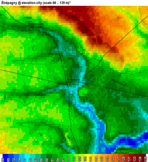
Below is the Elevation map of Étrépagny, which displays elevation range with different colors. Scale of the first map is from 66 to 139 m (217 to 456 ft) with average elevation of 99.9 meters (=328 ft) [note 1]
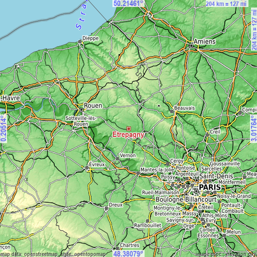
These maps also provides idea of topography and contour of this city, they are displayed at different zoom levels. More info about maps, scale and edge coordinates you can find below images.
| \ | Map #1 | Map #2 | Topo.Map |
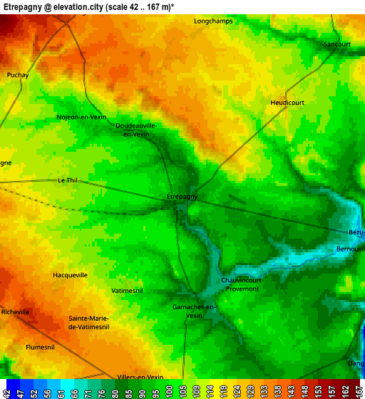
| Scale [m] | 66..139 m | 42..167 m | × |
| Scale [ft] | 217..456 ft | 138..548 ft | × |
| Average | 99.9 m = 328 ft | 107.5 m = 353 ft | × |
| Width | 6.37 km = 4 mi | 12.74 km = 7.9 mi | 203.9 km = 126.7 mi |
| Height | 6.37 km = 4 mi | 12.74 km = 7.9 mi | 203.9 km = 126.7 mi |
| ↑Max Latitude | 49.334875° | 49.363503° | 50.21461° |
| Latitude at center | 49.30623° | 49.30623° | 49.30623° |
| ↓Min Latitude | 49.277569° | 49.248891° | 48.38079° |
| ← Min Longitude | 1.567445° | 1.523499° | 0.20514° |
| Longitude center | 1.61139° | 1.61139° | 1.61139° |
| →Max Longitude | 1.655335° | 1.699281° | 3.01764° |
Nearby cities:
Cities around Étrépagny sort by population:
• Gisors elevation 52 m
12.5 km,  102°
102°
• Les Andelys 37 m
16 km,  245°
245°
• Magny-en-Vexin 82 m
21.1 km,  142°
142°
• Chaumont-en-Vexin 67 m
20.4 km, 102°
• Sérifontaine 70 m
12.6 km,  64°
64°
• Fleury-sur-Andelle 32 m
19.5 km,  288°
288°
• Charleval 36 m
18.1 km, 294°
• Saint-Germer-de-Fly 101 m
19.5 km,  38°
38°
• Trie-Château 64 m
15.4 km, 98°
• Bézu-Saint-Éloi 67 m
6.8 km, 100°
• La Feuillie 178 m
18.9 km,  338°
338°
• Neaufles-Saint-Martin 69 m
9.1 km,  111°
111°
Multilingual:
 En español:
Étrépagny elevación 86 m.
 En France:
Étrépagny élévation 86 m.
 Auf Deutsch:
Étrépagny höhe über dem Meeresspiegel ist 86 m.

Sources and notes:
- [note 1] Map square and city borders are not equal. Map elevation data is calculated only from area inside that square.
- [src 1] Elevation data from geonames database provided with same terms of usage.
- [src 2] The elevation map of Étrépagny is generated using elevation data from NASA's 3 arcsec (90m) resolution SRTM data.
- [src 3] Base (background) map © OpenStreetMap contributors tiles are generated by Geofabrik and OpenTopoMap.
Copyright & License:
This Étrépagny Elevation Map is licensed under CC BY-SA. You may reuse any part from this page, if you give a proper credit by linking to this URL:
 More info on terms of use page.