Saint-Germer-de-Fly elevation
Saint-Germer-de-Fly (Hauts-de-France, Département de l'Oise), France elevation is 101 meters and Saint-Germer-de-Fly elevation in feet is 331 ft above sea level [src 1]. Saint-Germer-de-Fly is a populated place (feature code) with elevation that is 73 meters (240 ft) smaller than average city elevation in France.
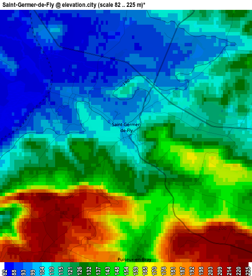
Below is the Elevation map of Saint-Germer-de-Fly, which displays elevation range with different colors. Scale of the first map is from 82 to 225 m (269 to 738 ft) with average elevation of 129.9 meters (=426 ft) [note 1]
These maps also provides idea of topography and contour of this city, they are displayed at different zoom levels. More info about maps, scale and edge coordinates you can find below images.
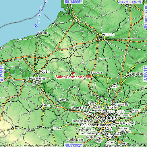
| \ | Map #1 | Topo.Map |
| Scale [m] | 82..225 m | × |
| Scale [ft] | 269..738 ft | × |
| Average | 129.9 m = 426 ft | × |
| Width | 6.35 km = 3.9 mi | 203.3 km = 126.3 mi |
| Height | 6.35 km = 3.9 mi | 203.3 km = 126.3 mi |
| ↑Max Latitude | 49.471375° | 50.34865° |
| Latitude at center | 49.44281° | 49.44281° |
| ↓Min Latitude | 49.414228° | 48.51992° |
| ← Min Longitude | 1.735915° | 0.37361° |
| Longitude center | 1.77986° | 1.77986° |
| →Max Longitude | 1.823805° | 3.18611° |
Nearby cities:
Cities around Saint-Germer-de-Fly sort by population:
• Gisors elevation 52 m
17.9 km,  179°
179°
• Gournay-en-Bray 99 m
6 km,  318°
318°
• Auneuil 126 m
17.7 km,  117°
117°
• Sérifontaine 70 m
9.9 km, 184°
• Milly-sur-Thérain 83 m
17 km,  67°
67°
• Lachapelle-aux-Pots 110 m
8.9 km,  85°
85°
• Trie-Château 64 m
17.8 km,  170°
170°
• Saint-Paul 110 m
16.5 km,  95°
95°
• Ons-en-Bray 122 m
10.8 km,  105°
105°
• Songeons 115 m
13 km,  24°
24°
• Bézu-Saint-Éloi 67 m
17.3 km,  198°
198°
• Saint-Aubin-en-Bray 138 m
7.5 km, 109°
Multilingual:
 En español:
Saint-Germer-de-Fly elevación 101 m.
 En France:
Saint-Germer-de-Fly élévation 101 m.
 Auf Deutsch:
Saint-Germer-de-Fly höhe über dem Meeresspiegel ist 101 m.
 На русском:
Saint-Germer-de-Fly высота над уровнем моря 101 м
Sources and notes:
- [note 1] Map square and city borders are not equal. Map elevation data is calculated only from area inside that square.
- [src 1] Elevation data from geonames database provided with same terms of usage.
- [src 2] The elevation map of Saint-Germer-de-Fly is generated using elevation data from NASA's 3 arcsec (90m) resolution SRTM data.
- [src 3] Base (background) map © OpenStreetMap contributors tiles are generated by Geofabrik and OpenTopoMap.
Copyright & License:
This Saint-Germer-de-Fly Elevation Map is licensed under CC BY-SA. You may reuse any part from this page, if you give a proper credit by linking to this URL:
 More info on terms of use page.