Foix elevation
Foix (Occitanie, Département de l'Ariège), France elevation is 392 meters and Foix elevation in feet is 1286 ft above sea level [src 1]. Foix is a seat of a second-order administrative division (feature code) with elevation that is 218 meters (715 ft) bigger than average city elevation in France.
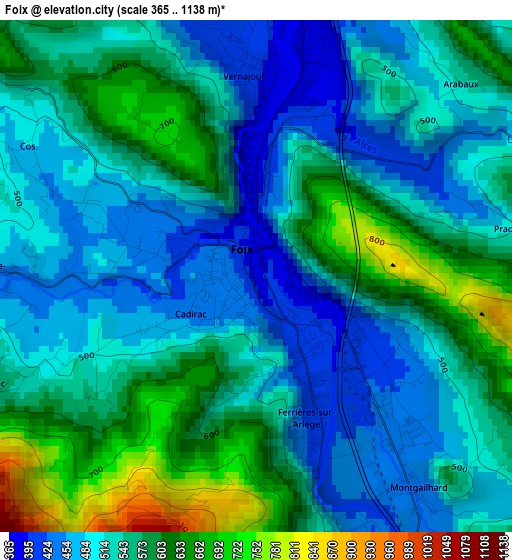
Below is the Elevation map of Foix, which displays elevation range with different colors. Scale of the first map is from 365 to 1138 m (1198 to 3734 ft) with average elevation of 540.9 meters (=1775 ft) [note 1]
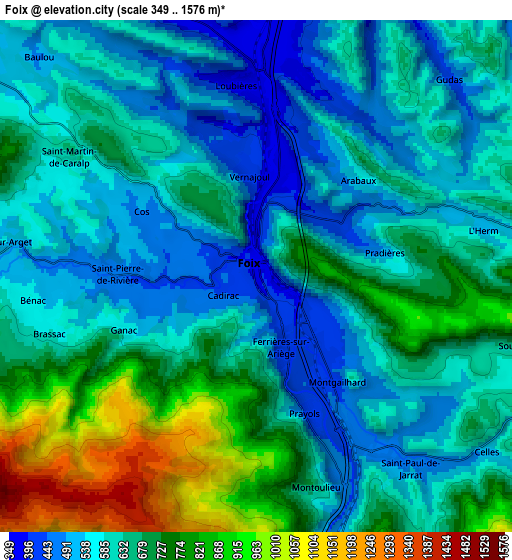
These maps also provides idea of topography and contour of this city, they are displayed at different zoom levels. More info about maps, scale and edge coordinates you can find below images.
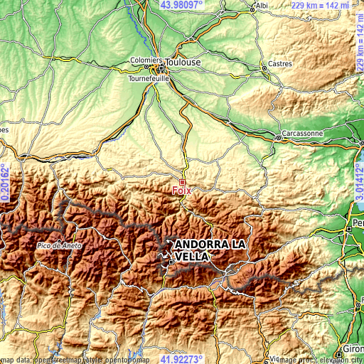
| \ | Map #1 | Map #2 | Topo.Map |
| Scale [m] | 365..1138 m | 349..1576 m | × |
| Scale [ft] | 1198..3734 ft | 1145..5171 ft | × |
| Average | 540.9 m = 1775 ft | 643.4 m = 2111 ft | × |
| Width | 7.15 km = 4.4 mi | 14.3 km = 8.9 mi | 228.9 km = 142.2 mi |
| Height | 7.15 km = 4.4 mi | 14.3 km = 8.9 mi | 228.8 km = 142.2 mi |
| ↑Max Latitude | 42.992612° | 43.024747° | 43.98097° |
| Latitude at center | 42.96046° | 42.96046° | 42.96046° |
| ↓Min Latitude | 42.928291° | 42.896106° | 41.92273° |
| ← Min Longitude | 1.563925° | 1.519979° | 0.20162° |
| Longitude center | 1.60787° | 1.60787° | 1.60787° |
| →Max Longitude | 1.651815° | 1.695761° | 3.01412° |
Nearby cities:
Cities around Foix sort by population:
• Pamiers elevation 300 m
17.4 km,  0°
0°
• Lavelanet 529 m
19.7 km,  99°
99°
• Tarascon-sur-Ariège 478 m
12.8 km,  181°
181°
• Varilhes 339 m
9.6 km,  9°
9°
• Laroque-d’Olmes 454 m
21.1 km,  87°
87°
• Saint-Jean-du-Falga 315 m
14.1 km, 6°
• La Tour-du-Crieu 314 m
16.4 km, 12°
• Verniolle 323 m
13.9 km, 13°
• Montgaillard 436 m
3.7 km,  145°
145°
• Saint-Paul-de-Jarrat 467 m
6.4 km,  143°
143°
• Villeneuve-d’Olmes 609 m
18.2 km,  109°
109°
• Mercus-Garrabet 485 m
9.3 km,  169°
169°
Multilingual:
 En español:
Foix elevación 392 m.
 En France:
Foix élévation 392 m.


Sources and notes:
- [note 1] Map square and city borders are not equal. Map elevation data is calculated only from area inside that square.
- [src 1] Elevation data from geonames database provided with same terms of usage.
- [src 2] The elevation map of Foix is generated using elevation data from NASA's 3 arcsec (90m) resolution SRTM data.
- [src 3] Base (background) map © OpenStreetMap contributors tiles are generated by Geofabrik and OpenTopoMap.
Copyright & License:
This Foix Elevation Map is licensed under CC BY-SA. You may reuse any part from this page, if you give a proper credit by linking to this URL:
 More info on terms of use page.