Pamiers elevation
Pamiers (Occitanie, Département de l'Ariège), France elevation is 300 meters and Pamiers elevation in feet is 984 ft above sea level [src 1]. Pamiers is a seat of a third-order administrative division (feature code) with elevation that is 126 meters (413 ft) bigger than average city elevation in France.
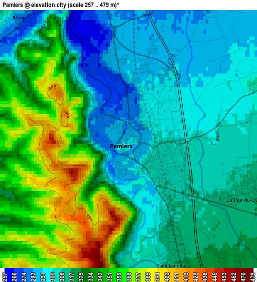
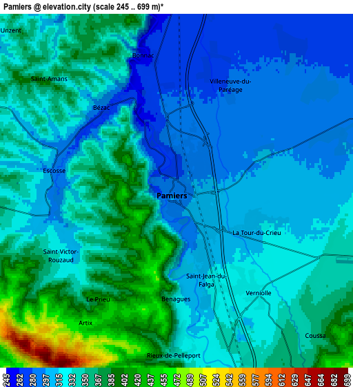
Below is the Elevation map of Pamiers, which displays elevation range with different colors. Scale of the first map is from 257 to 479 m (843 to 1572 ft) with average elevation of 322.8 meters (=1059 ft) [note 1]
These maps also provides idea of topography and contour of this city, they are displayed at different zoom levels. More info about maps, scale and edge coordinates you can find below images.
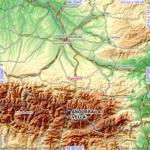
| \ | Map #1 | Map #2 | Topo.Map |
| Scale [m] | 257..479 m | 245..699 m | × |
| Scale [ft] | 843..1572 ft | 804..2293 ft | × |
| Average | 322.8 m = 1059 ft | 335.5 m = 1101 ft | × |
| Width | 7.13 km = 4.4 mi | 14.27 km = 8.9 mi | 228.3 km = 141.9 mi |
| Height | 7.13 km = 4.4 mi | 14.27 km = 8.9 mi | 228.3 km = 141.9 mi |
| ↑Max Latitude | 43.14857° | 43.180623° | 44.1344° |
| Latitude at center | 43.1165° | 43.1165° | 43.1165° |
| ↓Min Latitude | 43.084413° | 43.052309° | 42.08138° |
| ← Min Longitude | 1.566845° | 1.522899° | 0.20454° |
| Longitude center | 1.61079° | 1.61079° | 1.61079° |
| →Max Longitude | 1.654735° | 1.698681° | 3.01704° |
Nearby cities:
Cities around Pamiers sort by population:
• Foix elevation 392 m
17.4 km,  180°
180°
• Saverdun 236 m
13.5 km,  347°
347°
• Mirepoix 310 m
21.6 km,  98°
98°
• Mazères 244 m
15.8 km,  19°
19°
• Varilhes 339 m
8.1 km,  169°
169°
• Saint-Jean-du-Falga 315 m
3.6 km,  157°
157°
• La Tour-du-Crieu 314 m
3.6 km,  111°
111°
• Verniolle 323 m
5 km,  141°
141°
• Calmont 215 m
19 km,  4°
4°
• Montgaillard 436 m
20.4 km, 174°
• Belpech 246 m
14.7 km,  51°
51°
• Gaillac-Toulza 240 m
19.1 km,  323°
323°
Multilingual:
 En español:
Pamiers elevación 300 m.
 En France:
Pamiers élévation 300 m.


Sources and notes:
- [note 1] Map square and city borders are not equal. Map elevation data is calculated only from area inside that square.
- [src 1] Elevation data from geonames database provided with same terms of usage.
- [src 2] The elevation map of Pamiers is generated using elevation data from NASA's 3 arcsec (90m) resolution SRTM data.
- [src 3] Base (background) map © OpenStreetMap contributors tiles are generated by Geofabrik and OpenTopoMap.
Copyright & License:
This Pamiers Elevation Map is licensed under CC BY-SA. You may reuse any part from this page, if you give a proper credit by linking to this URL:
 More info on terms of use page.