Gaillac-Toulza elevation
Gaillac-Toulza (Occitanie, Haute-Garonne), France elevation is 240 meters and Gaillac-Toulza elevation in feet is 787 ft above sea level [src 1]. Gaillac-Toulza is a populated place (feature code) with elevation that is 66 meters (217 ft) bigger than average city elevation in France.
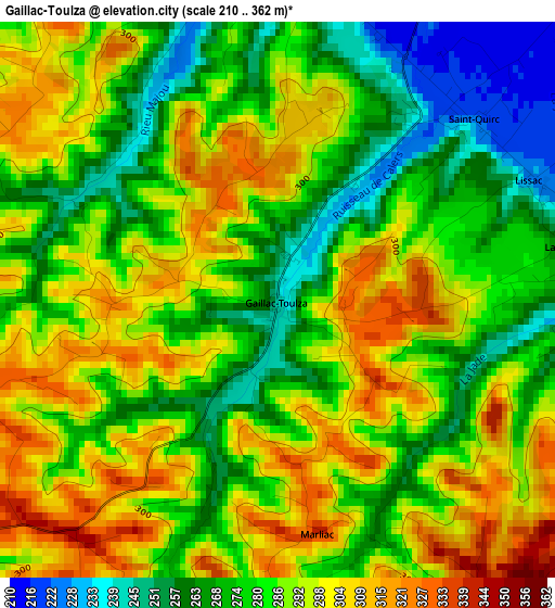
Below is the Elevation map of Gaillac-Toulza, which displays elevation range with different colors. Scale of the first map is from 210 to 362 m (689 to 1188 ft) with average elevation of 285.1 meters (=935 ft) [note 1]
These maps also provides idea of topography and contour of this city, they are displayed at different zoom levels. More info about maps, scale and edge coordinates you can find below images.
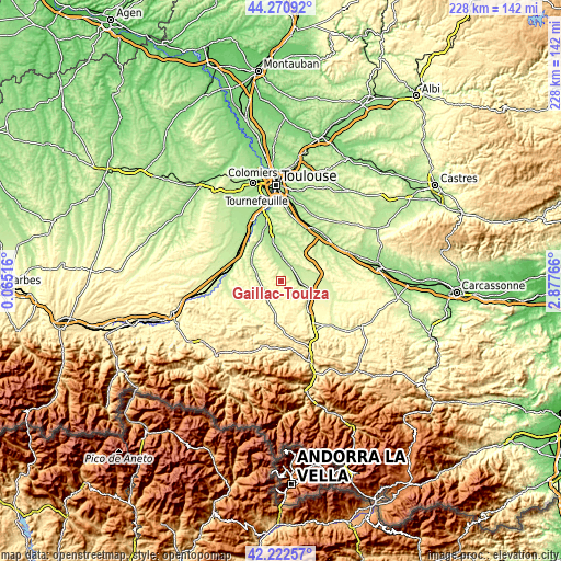
| \ | Map #1 | Topo.Map |
| Scale [m] | 210..362 m | × |
| Scale [ft] | 689..1188 ft | × |
| Average | 285.1 m = 935 ft | × |
| Width | 7.12 km = 4.4 mi | 227.8 km = 141.5 mi |
| Height | 7.12 km = 4.4 mi | 227.7 km = 141.5 mi |
| ↑Max Latitude | 43.287357° | 44.27092° |
| Latitude at center | 43.25536° | 43.25536° |
| ↓Min Latitude | 43.223346° | 42.22257° |
| ← Min Longitude | 1.427465° | 0.06516° |
| Longitude center | 1.47141° | 1.47141° |
| →Max Longitude | 1.515355° | 2.87766° |
Nearby cities:
Cities around Gaillac-Toulza sort by population:
• Pamiers elevation 300 m
19.1 km,  143°
143°
• Auterive 194 m
10.7 km,  2°
2°
• Saverdun 236 m
8.6 km,  105°
105°
• Mazères 244 m
16.7 km,  91°
91°
• Cintegabelle 221 m
8.1 km,  37°
37°
• Lagardelle-sur-Lèze 191 m
18.6 km,  339°
339°
• Lézat-sur-Lèze 221 m
10.4 km,  283°
283°
• Saint-Sulpice-sur-Lèze 206 m
14.8 km,  304°
304°
• Calmont 215 m
13.3 km,  74°
74°
• Miremont 197 m
13.5 km, 341°
• Beaumont-sur-Lèze 201 m
16.7 km,  326°
326°
• Nailloux 280 m
16.7 km,  47°
47°
Multilingual:
 En español:
Gaillac-Toulza elevación 240 m.
 En France:
Gaillac-Toulza élévation 240 m.
 Auf Deutsch:
Gaillac-Toulza höhe über dem Meeresspiegel ist 240 m.

Sources and notes:
- [note 1] Map square and city borders are not equal. Map elevation data is calculated only from area inside that square.
- [src 1] Elevation data from geonames database provided with same terms of usage.
- [src 2] The elevation map of Gaillac-Toulza is generated using elevation data from NASA's 3 arcsec (90m) resolution SRTM data.
- [src 3] Base (background) map © OpenStreetMap contributors tiles are generated by Geofabrik and OpenTopoMap.
Copyright & License:
This Gaillac-Toulza Elevation Map is licensed under CC BY-SA. You may reuse any part from this page, if you give a proper credit by linking to this URL:
 More info on terms of use page.