Lézat-sur-Lèze elevation
Lézat-sur-Lèze (Occitanie, Département de l'Ariège), France elevation is 221 meters and Lézat-sur-Lèze elevation in feet is 725 ft above sea level [src 1]. Lézat-sur-Lèze is a populated place (feature code) with elevation that is 47 meters (154 ft) bigger than average city elevation in France.
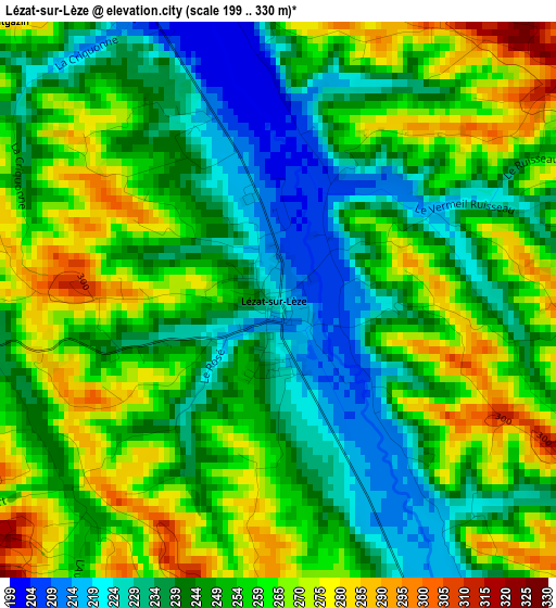
Below is the Elevation map of Lézat-sur-Lèze, which displays elevation range with different colors. Scale of the first map is from 199 to 330 m (653 to 1083 ft) with average elevation of 251.4 meters (=825 ft) [note 1]
These maps also provides idea of topography and contour of this city, they are displayed at different zoom levels. More info about maps, scale and edge coordinates you can find below images.
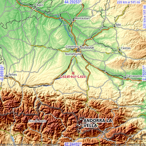
| \ | Map #1 | Topo.Map |
| Scale [m] | 199..330 m | × |
| Scale [ft] | 653..1083 ft | × |
| Average | 251.4 m = 825 ft | × |
| Width | 7.11 km = 4.4 mi | 227.7 km = 141.5 mi |
| Height | 7.11 km = 4.4 mi | 227.7 km = 141.5 mi |
| ↑Max Latitude | 43.309326° | 44.29253° |
| Latitude at center | 43.27734° | 43.27734° |
| ↓Min Latitude | 43.245337° | 42.24492° |
| ← Min Longitude | 1.302915° | -0.05939° |
| Longitude center | 1.34686° | 1.34686° |
| →Max Longitude | 1.390805° | 2.75311° |
Nearby cities:
Cities around Lézat-sur-Lèze sort by population:
• Auterive elevation 194 m
13.4 km,  52°
52°
• Carbonne 211 m
10.1 km,  283°
283°
• Montesquieu-Volvestre 231 m
12.3 km,  230°
230°
• Noé 199 m
10.6 km,  327°
327°
• Longages 204 m
12.2 km,  314°
314°
• Rieux-Volvestre 218 m
12.3 km,  255°
255°
• Saint-Sulpice-sur-Lèze 206 m
6.3 km,  340°
340°
• Miremont 197 m
11.8 km,  28°
28°
• Beaumont-sur-Lèze 201 m
11.6 km,  4°
4°
• Le Fauga 190 m
13.8 km, 342°
• Gaillac-Toulza 240 m
10.4 km,  103°
103°
• Marquefave 199 m
9.3 km,  298°
298°
Multilingual:
 En español:
Lézat-sur-Lèze elevación 221 m.
 En France:
Lézat-sur-Lèze élévation 221 m.
 Auf Deutsch:
Lézat-sur-Lèze höhe über dem Meeresspiegel ist 221 m.

Sources and notes:
- [note 1] Map square and city borders are not equal. Map elevation data is calculated only from area inside that square.
- [src 1] Elevation data from geonames database provided with same terms of usage.
- [src 2] The elevation map of Lézat-sur-Lèze is generated using elevation data from NASA's 3 arcsec (90m) resolution SRTM data.
- [src 3] Base (background) map © OpenStreetMap contributors tiles are generated by Geofabrik and OpenTopoMap.
Copyright & License:
This Lézat-sur-Lèze Elevation Map is licensed under CC BY-SA. You may reuse any part from this page, if you give a proper credit by linking to this URL:
 More info on terms of use page.