Ginasservis elevation
Ginasservis (Provence-Alpes-Côte d'Azur, Var), France elevation is 423 meters and Ginasservis elevation in feet is 1388 ft above sea level [src 1]. Ginasservis is a populated place (feature code) with elevation that is 249 meters (817 ft) bigger than average city elevation in France.
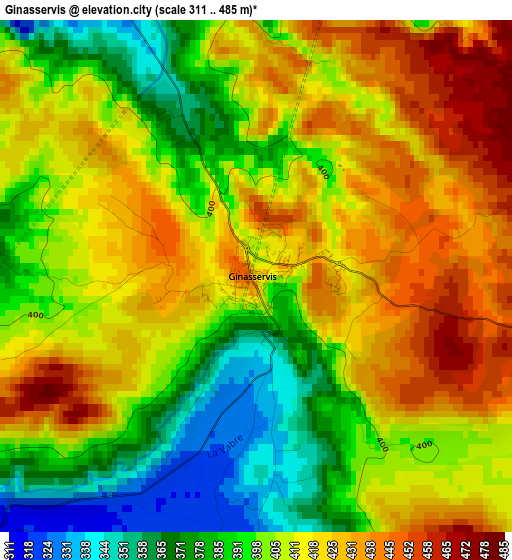
Below is the Elevation map of Ginasservis, which displays elevation range with different colors. Scale of the first map is from 311 to 485 m (1020 to 1591 ft) with average elevation of 407.4 meters (=1337 ft) [note 1]
These maps also provides idea of topography and contour of this city, they are displayed at different zoom levels. More info about maps, scale and edge coordinates you can find below images.
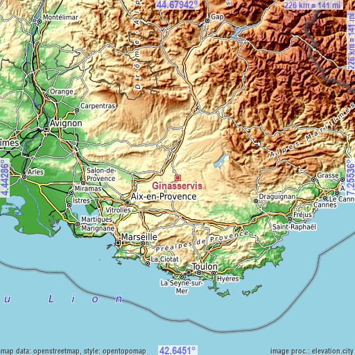
| \ | Map #1 | Topo.Map |
| Scale [m] | 311..485 m | × |
| Scale [ft] | 1020..1591 ft | × |
| Average | 407.4 m = 1337 ft | × |
| Width | 7.07 km = 4.4 mi | 226.2 km = 140.6 mi |
| Height | 7.07 km = 4.4 mi | 226.2 km = 140.6 mi |
| ↑Max Latitude | 43.702658° | 44.67942° |
| Latitude at center | 43.67088° | 43.67088° |
| ↓Min Latitude | 43.639085° | 42.6451° |
| ← Min Longitude | 5.805165° | 4.44286° |
| Longitude center | 5.84911° | 5.84911° |
| →Max Longitude | 5.893055° | 7.25536° |
Nearby cities:
Cities around Ginasservis sort by population:
• Manosque elevation 364 m
18.3 km,  344°
344°
• Pourrières 304 m
20.5 km,  206°
206°
• Rians 392 m
10.3 km,  226°
226°
• Pierrevert 394 m
17.5 km,  332°
332°
• Jouques 310 m
17.5 km,  257°
257°
• Sainte-Tulle 304 m
14.5 km, 332°
• Vinon-sur-Verdon 275 m
6.7 km, 333°
• Barjols 265 m
17.9 km,  134°
134°
• Gréoux-les-Bains 349 m
10.1 km,  15°
15°
• Puyloubier 350 m
21.3 km,  220°
220°
• Saint-Julien 464 m
5.2 km,  64°
64°
• Beaumont-de-Pertuis 333 m
14.8 km,  299°
299°
Multilingual:
 En español:
Ginasservis elevación 423 m.
 En France:
Ginasservis élévation 423 m.
 Auf Deutsch:
Ginasservis höhe über dem Meeresspiegel ist 423 m.

Sources and notes:
- [note 1] Map square and city borders are not equal. Map elevation data is calculated only from area inside that square.
- [src 1] Elevation data from geonames database provided with same terms of usage.
- [src 2] The elevation map of Ginasservis is generated using elevation data from NASA's 3 arcsec (90m) resolution SRTM data.
- [src 3] Base (background) map © OpenStreetMap contributors tiles are generated by Geofabrik and OpenTopoMap.
Copyright & License:
This Ginasservis Elevation Map is licensed under CC BY-SA. You may reuse any part from this page, if you give a proper credit by linking to this URL:
 More info on terms of use page.