Huez elevation
Huez (Auvergne-Rhône-Alpes, Département de l'Isère), France elevation is 1509 meters and Huez elevation in feet is 4951 ft above sea level [src 1]. Huez is a populated place (feature code) with elevation that is 1335 meters (4380 ft) bigger than average city elevation in France.
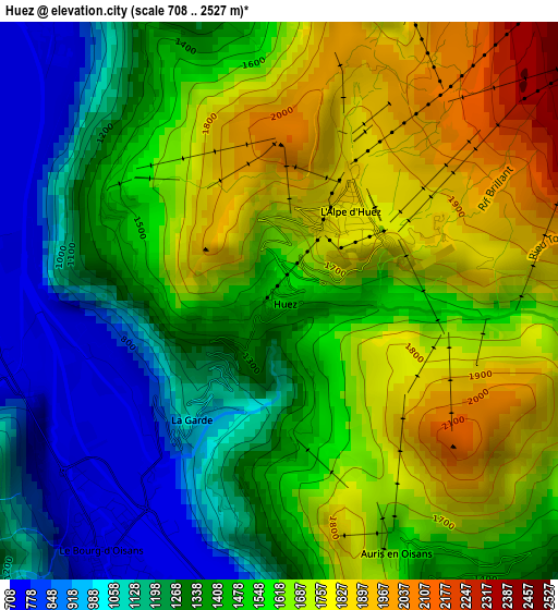
Below is the Elevation map of Huez, which displays elevation range with different colors. Scale of the first map is from 708 to 2527 m (2323 to 8291 ft) with average elevation of 1481.6 meters (=4861 ft) [note 1]
These maps also provides idea of topography and contour of this city, they are displayed at different zoom levels. More info about maps, scale and edge coordinates you can find below images.
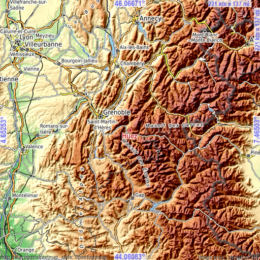
| \ | Map #1 | Topo.Map |
| Scale [m] | 708..2527 m | × |
| Scale [ft] | 2323..8291 ft | × |
| Average | 1481.6 m = 4861 ft | × |
| Width | 6.9 km = 4.3 mi | 220.8 km = 137.2 mi |
| Height | 6.9 km = 4.3 mi | 220.8 km = 137.2 mi |
| ↑Max Latitude | 45.113421° | 46.06671° |
| Latitude at center | 45.0824° | 45.0824° |
| ↓Min Latitude | 45.051362° | 44.08083° |
| ← Min Longitude | 6.014835° | 4.65253° |
| Longitude center | 6.05878° | 6.05878° |
| →Max Longitude | 6.102725° | 7.46503° |
Nearby cities:
Cities around Huez sort by population:
• Villard-Bonnot elevation 237 m
21.8 km,  320°
320°
• Domène 238 m
22.2 km,  307°
307°
• Le Versoud 238 m
21.6 km, 315°
• Le Bourg-d’Oisans 716 m
3.6 km,  212°
212°
• Vaulnaveys-le-Haut 490 m
19.5 km,  284°
284°
• Brié-et-Angonnes 442 m
22.1 km, 282°
• Les Deux Alpes 1655 m
9.5 km,  146°
146°
• Livet-et-Gavet 648 m
10.2 km,  286°
286°
• Vaulnaveys-le-Bas 904 m
18.4 km, 276°
• Revel 790 m
18.6 km, 308°
• Herbeys 603 m
21.8 km, 287°
• Mont-de-Lans 1269 m
7.7 km,  131°
131°
Multilingual:
 En español:
Huez elevación 1509 m.
 En France:
Huez élévation 1509 m.


Sources and notes:
- [note 1] Map square and city borders are not equal. Map elevation data is calculated only from area inside that square.
- [src 1] Elevation data from geonames database provided with same terms of usage.
- [src 2] The elevation map of Huez is generated using elevation data from NASA's 3 arcsec (90m) resolution SRTM data.
- [src 3] Base (background) map © OpenStreetMap contributors tiles are generated by Geofabrik and OpenTopoMap.
Copyright & License:
This Huez Elevation Map is licensed under CC BY-SA. You may reuse any part from this page, if you give a proper credit by linking to this URL:
 More info on terms of use page.