Mont-de-Lans elevation
Mont-de-Lans (Auvergne-Rhône-Alpes, Département de l'Isère), France elevation is 1269 meters and Mont-de-Lans elevation in feet is 4163 ft above sea level [src 1]. Mont-de-Lans is a populated place (feature code) with elevation that is 1095 meters (3593 ft) bigger than average city elevation in France.
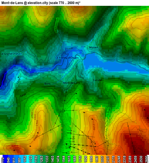
Below is the Elevation map of Mont-de-Lans, which displays elevation range with different colors. Scale of the first map is from 770 to 2600 m (2526 to 8530 ft) with average elevation of 1570.2 meters (=5152 ft) [note 1]
These maps also provides idea of topography and contour of this city, they are displayed at different zoom levels. More info about maps, scale and edge coordinates you can find below images.
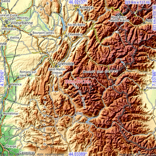
| \ | Map #1 | Topo.Map |
| Scale [m] | 770..2600 m | × |
| Scale [ft] | 2526..8530 ft | × |
| Average | 1570.2 m = 5152 ft | × |
| Width | 6.91 km = 4.3 mi | 221 km = 137.3 mi |
| Height | 6.91 km = 4.3 mi | 221 km = 137.3 mi |
| ↑Max Latitude | 45.067306° | 46.02137° |
| Latitude at center | 45.03626° | 45.03626° |
| ↓Min Latitude | 45.005197° | 44.03389° |
| ← Min Longitude | 6.087465° | 4.72516° |
| Longitude center | 6.13141° | 6.13141° |
| →Max Longitude | 6.175355° | 7.53766° |
Nearby cities:
Cities around Mont-de-Lans sort by population:
• Vizille elevation 279 m
28.7 km,  279°
279°
• Le Versoud 238 m
29.2 km,  314°
314°
• Le Bourg-d’Oisans 716 m
8 km,  285°
285°
• Vaulnaveys-le-Haut 490 m
26.6 km, 291°
• Brié-et-Angonnes 442 m
29 km, 289°
• Huez 1509 m
7.7 km, 311°
• Les Deux Alpes 1655 m
2.8 km,  189°
189°
• Livet-et-Gavet 648 m
17.5 km,  297°
297°
• Valloire 1404 m
27.5 km,  58°
58°
• Vaulnaveys-le-Bas 904 m
25.1 km, 286°
• Revel 790 m
26.3 km, 309°
• Herbeys 603 m
29 km, 293°
Multilingual:
 En español:
Mont-de-Lans elevación 1269 m.
 En France:
Mont-de-Lans élévation 1269 m.
 Auf Deutsch:
Mont-de-Lans höhe über dem Meeresspiegel ist 1269 m.

Sources and notes:
- [note 1] Map square and city borders are not equal. Map elevation data is calculated only from area inside that square.
- [src 1] Elevation data from geonames database provided with same terms of usage.
- [src 2] The elevation map of Mont-de-Lans is generated using elevation data from NASA's 3 arcsec (90m) resolution SRTM data.
- [src 3] Base (background) map © OpenStreetMap contributors tiles are generated by Geofabrik and OpenTopoMap.
Copyright & License:
This Mont-de-Lans Elevation Map is licensed under CC BY-SA. You may reuse any part from this page, if you give a proper credit by linking to this URL:
 More info on terms of use page.