Villard-Bonnot elevation
Villard-Bonnot (Auvergne-Rhône-Alpes, Département de l'Isère), France elevation is 237 meters and Villard-Bonnot elevation in feet is 778 ft above sea level [src 1]. Villard-Bonnot is a populated place (feature code) with elevation that is 63 meters (207 ft) bigger than average city elevation in France.
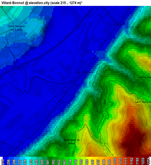
Below is the Elevation map of Villard-Bonnot, which displays elevation range with different colors. Scale of the first map is from 215 to 1274 m (705 to 4180 ft) with average elevation of 448.4 meters (=1471 ft) [note 1]
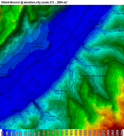
These maps also provides idea of topography and contour of this city, they are displayed at different zoom levels. More info about maps, scale and edge coordinates you can find below images.
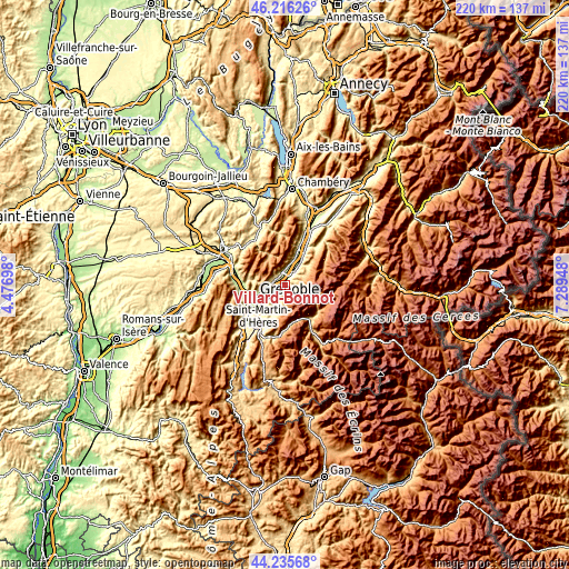
| \ | Map #1 | Map #2 | Topo.Map |
| Scale [m] | 215..1274 m | 213..2694 m | × |
| Scale [ft] | 705..4180 ft | 699..8839 ft | × |
| Average | 448.4 m = 1471 ft | 691 m = 2267 ft | × |
| Width | 6.88 km = 4.3 mi | 13.76 km = 8.6 mi | 220.2 km = 136.8 mi |
| Height | 6.88 km = 4.3 mi | 13.76 km = 8.6 mi | 220.2 km = 136.8 mi |
| ↑Max Latitude | 45.265538° | 45.296459° | 46.21626° |
| Latitude at center | 45.2346° | 45.2346° | 45.2346° |
| ↓Min Latitude | 45.203645° | 45.172673° | 44.23568° |
| ← Min Longitude | 5.839285° | 5.795339° | 4.47698° |
| Longitude center | 5.88323° | 5.88323° | 5.88323° |
| →Max Longitude | 5.927175° | 5.971121° | 7.28948° |
Nearby cities:
Cities around Villard-Bonnot sort by population:
• Crolles elevation 230 m
4.8 km,  355°
355°
• Domène 238 m
5.3 km,  227°
227°
• Saint-Ismier 351 m
4.6 km,  295°
295°
• Montbonnot-Saint-Martin 263 m
6.5 km,  260°
260°
• Le Versoud 238 m
2.2 km,  221°
221°
• Froges 237 m
5.3 km,  34°
34°
• Bernin 262 m
4 km,  338°
338°
• Biviers 363 m
6.5 km,  268°
268°
• Saint-Nazaire-les-Eymes 284 m
2.9 km, 304°
• Saint-Hilaire 1026 m
7.3 km,  0°
0°
• Revel 790 m
5.5 km,  189°
189°
• Le Champ-près-Froges 364 m
6.8 km,  40°
40°
Multilingual:
 En español:
Villard-Bonnot elevación 237 m.
 En France:
Villard-Bonnot élévation 237 m.
 Auf Deutsch:
Villard-Bonnot höhe über dem Meeresspiegel ist 237 m.

Sources and notes:
- [note 1] Map square and city borders are not equal. Map elevation data is calculated only from area inside that square.
- [src 1] Elevation data from geonames database provided with same terms of usage.
- [src 2] The elevation map of Villard-Bonnot is generated using elevation data from NASA's 3 arcsec (90m) resolution SRTM data.
- [src 3] Base (background) map © OpenStreetMap contributors tiles are generated by Geofabrik and OpenTopoMap.
Copyright & License:
This Villard-Bonnot Elevation Map is licensed under CC BY-SA. You may reuse any part from this page, if you give a proper credit by linking to this URL:
 More info on terms of use page.