Jarny elevation
Jarny (Grand Est, Meurthe-et-Moselle), France elevation is 198 meters and Jarny elevation in feet is 650 ft above sea level [src 1]. Jarny is a populated place (feature code) with elevation that is 24 meters (79 ft) bigger than average city elevation in France.
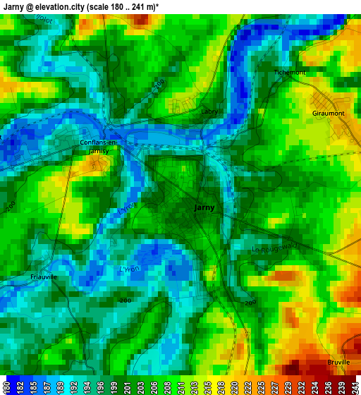
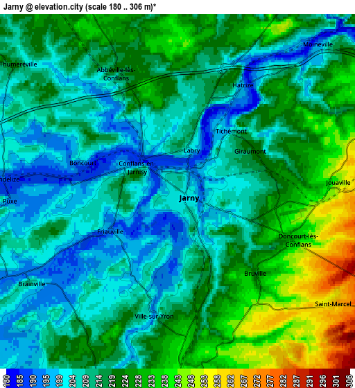
Below is the Elevation map of Jarny, which displays elevation range with different colors. Scale of the first map is from 180 to 241 m (591 to 791 ft) with average elevation of 202.7 meters (=665 ft) [note 1]
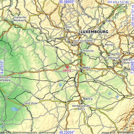
These maps also provides idea of topography and contour of this city, they are displayed at different zoom levels. More info about maps, scale and edge coordinates you can find below images.
| \ | Map #1 | Map #2 | Topo.Map |
| Scale [m] | 180..241 m | 180..306 m | × |
| Scale [ft] | 591..791 ft | 591..1004 ft | × |
| Average | 202.7 m = 665 ft | 216.3 m = 710 ft | × |
| Width | 6.39 km = 4 mi | 12.78 km = 7.9 mi | 204.5 km = 127.1 mi |
| Height | 6.39 km = 4 mi | 12.78 km = 7.9 mi | 204.5 km = 127.1 mi |
| ↑Max Latitude | 49.18746° | 49.216174° | 50.06985° |
| Latitude at center | 49.15873° | 49.15873° | 49.15873° |
| ↓Min Latitude | 49.129983° | 49.101219° | 48.23054° |
| ← Min Longitude | 5.832455° | 5.788509° | 4.47015° |
| Longitude center | 5.8764° | 5.8764° | 5.8764° |
| →Max Longitude | 5.920345° | 5.964291° | 7.28265° |
Nearby cities:
Cities around Jarny sort by population:
• Homécourt elevation 195 m
10.9 km,  50°
50°
• Briey 248 m
11.1 km,  24°
24°
• Sainte-Marie-aux-Chênes 270 m
9.8 km,  67°
67°
• Auboué 230 m
9.4 km, 50°
• Conflans-en-Jarnisy 194 m
1.8 km,  301°
301°
• Valleroy 213 m
7.2 km,  38°
38°
• Moutiers 197 m
10.5 km, 38°
• Labry 193 m
1.6 km,  11°
11°
• Saint-Privat-la-Montagne 323 m
12.2 km, 74°
• Doncourt-lès-Conflans 251 m
4.5 km,  113°
113°
• Giraumont 217 m
3.1 km,  64°
64°
• Batilly 246 m
6.9 km,  76°
76°
Multilingual:
 En español:
Jarny elevación 198 m.
 En France:
Jarny élévation 198 m.


Sources and notes:
- [note 1] Map square and city borders are not equal. Map elevation data is calculated only from area inside that square.
- [src 1] Elevation data from geonames database provided with same terms of usage.
- [src 2] The elevation map of Jarny is generated using elevation data from NASA's 3 arcsec (90m) resolution SRTM data.
- [src 3] Base (background) map © OpenStreetMap contributors tiles are generated by Geofabrik and OpenTopoMap.
Copyright & License:
This Jarny Elevation Map is licensed under CC BY-SA. You may reuse any part from this page, if you give a proper credit by linking to this URL:
 More info on terms of use page.