Sainte-Marie-aux-Chênes elevation
Sainte-Marie-aux-Chênes (Grand Est, Moselle), France elevation is 270 meters and Sainte-Marie-aux-Chênes elevation in feet is 886 ft above sea level [src 1]. Sainte-Marie-aux-Chênes is a populated place (feature code) with elevation that is 96 meters (315 ft) bigger than average city elevation in France.
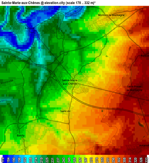
Below is the Elevation map of Sainte-Marie-aux-Chênes, which displays elevation range with different colors. Scale of the first map is from 178 to 332 m (584 to 1089 ft) with average elevation of 262.6 meters (=862 ft) [note 1]
These maps also provides idea of topography and contour of this city, they are displayed at different zoom levels. More info about maps, scale and edge coordinates you can find below images.
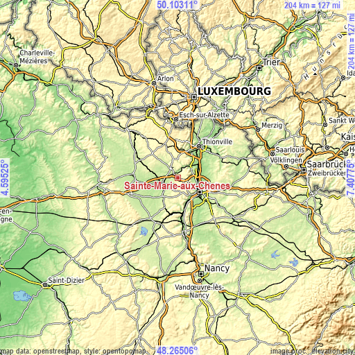
| \ | Map #1 | Topo.Map |
| Scale [m] | 178..332 m | × |
| Scale [ft] | 584..1089 ft | × |
| Average | 262.6 m = 862 ft | × |
| Width | 6.39 km = 4 mi | 204.4 km = 127 mi |
| Height | 6.39 km = 4 mi | 204.4 km = 127 mi |
| ↑Max Latitude | 49.221331° | 50.10311° |
| Latitude at center | 49.19262° | 49.19262° |
| ↓Min Latitude | 49.163893° | 48.26506° |
| ← Min Longitude | 5.957555° | 4.59525° |
| Longitude center | 6.0015° | 6.0015° |
| →Max Longitude | 6.045445° | 7.40775° |
Nearby cities:
Cities around Sainte-Marie-aux-Chênes sort by population:
• Moyeuvre-Grande elevation 222 m
7.4 km,  25°
25°
• Jœuf 195 m
4.7 km,  13°
13°
• Homécourt 195 m
3.2 km,  348°
348°
• Auboué 230 m
2.8 km,  319°
319°
• Montois-la-Montagne 280 m
3.1 km, 28°
• Valleroy 213 m
5 km,  291°
291°
• Amanvillers 325 m
4.1 km,  131°
131°
• Moutiers 197 m
5.2 km,  329°
329°
• Saint-Privat-la-Montagne 323 m
2.8 km,  101°
101°
• Doncourt-lès-Conflans 251 m
7.4 km,  221°
221°
• Giraumont 217 m
6.8 km,  248°
248°
• Batilly 246 m
3.2 km,  228°
228°
Multilingual:
 En español:
Sainte-Marie-aux-Chênes elevación 270 m.
 En France:
Sainte-Marie-aux-Chênes élévation 270 m.
 Auf Deutsch:
Sainte-Marie-aux-Chênes höhe über dem Meeresspiegel ist 270 m.

Sources and notes:
- [note 1] Map square and city borders are not equal. Map elevation data is calculated only from area inside that square.
- [src 1] Elevation data from geonames database provided with same terms of usage.
- [src 2] The elevation map of Sainte-Marie-aux-Chênes is generated using elevation data from NASA's 3 arcsec (90m) resolution SRTM data.
- [src 3] Base (background) map © OpenStreetMap contributors tiles are generated by Geofabrik and OpenTopoMap.
Copyright & License:
This Sainte-Marie-aux-Chênes Elevation Map is licensed under CC BY-SA. You may reuse any part from this page, if you give a proper credit by linking to this URL:
 More info on terms of use page.