Jœuf elevation
Jœuf (Grand Est, Meurthe-et-Moselle), France elevation is 195 meters and Jœuf elevation in feet is 640 ft above sea level [src 1]. Jœuf is a populated place (feature code) with elevation that is 21 meters (69 ft) bigger than average city elevation in France.
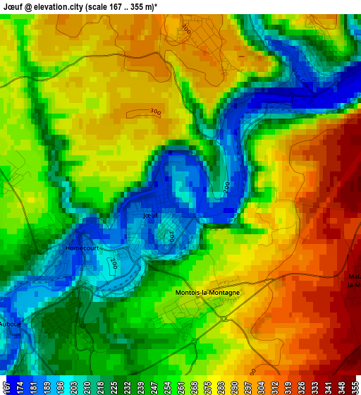
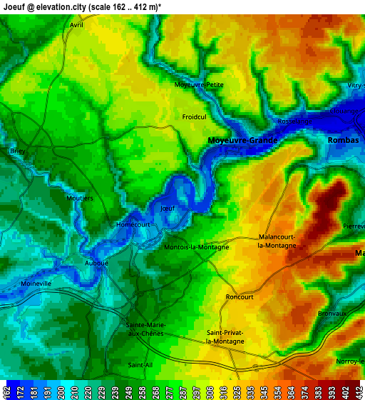
Below is the Elevation map of Jœuf, which displays elevation range with different colors. Scale of the first map is from 167 to 355 m (548 to 1165 ft) with average elevation of 258.6 meters (=848 ft) [note 1]
These maps also provides idea of topography and contour of this city, they are displayed at different zoom levels. More info about maps, scale and edge coordinates you can find below images.
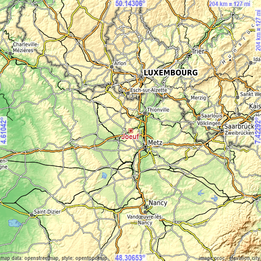
| \ | Map #1 | Map #2 | Topo.Map |
| Scale [m] | 167..355 m | 162..412 m | × |
| Scale [ft] | 548..1165 ft | 531..1352 ft | × |
| Average | 258.6 m = 848 ft | 272.8 m = 895 ft | × |
| Width | 6.38 km = 4 mi | 12.76 km = 7.9 mi | 204.2 km = 126.9 mi |
| Height | 6.38 km = 4 mi | 12.76 km = 7.9 mi | 204.2 km = 126.9 mi |
| ↑Max Latitude | 49.262017° | 49.290687° | 50.14306° |
| Latitude at center | 49.23333° | 49.23333° | 49.23333° |
| ↓Min Latitude | 49.204626° | 49.175906° | 48.30653° |
| ← Min Longitude | 5.972725° | 5.928779° | 4.61042° |
| Longitude center | 6.01667° | 6.01667° | 6.01667° |
| →Max Longitude | 6.060615° | 6.104561° | 7.42292° |
Nearby cities:
Cities around Jœuf sort by population:
• Rombas elevation 178 m
5.9 km,  72°
72°
• Moyeuvre-Grande 222 m
3 km,  42°
42°
• Homécourt 195 m
2.3 km,  231°
231°
• Briey 248 m
5.9 km,  287°
287°
• Sainte-Marie-aux-Chênes 270 m
4.7 km,  193°
193°
• Rosselange 185 m
4.7 km,  54°
54°
• Auboué 230 m
3.8 km, 230°
• Montois-la-Montagne 280 m
1.9 km,  169°
169°
• Valleroy 213 m
6.4 km,  245°
245°
• Moutiers 197 m
3.7 km,  269°
269°
• Saint-Privat-la-Montagne 323 m
5.3 km,  162°
162°
• Pierrevillers 222 m
6.4 km,  98°
98°
Multilingual:
 En español:
Jœuf elevación 195 m.
 En France:
Jœuf élévation 195 m.


Sources and notes:
- [note 1] Map square and city borders are not equal. Map elevation data is calculated only from area inside that square.
- [src 1] Elevation data from geonames database provided with same terms of usage.
- [src 2] The elevation map of Jœuf is generated using elevation data from NASA's 3 arcsec (90m) resolution SRTM data.
- [src 3] Base (background) map © OpenStreetMap contributors tiles are generated by Geofabrik and OpenTopoMap.
Copyright & License:
This Jœuf Elevation Map is licensed under CC BY-SA. You may reuse any part from this page, if you give a proper credit by linking to this URL:
 More info on terms of use page.