Saint-Privat-la-Montagne elevation
Saint-Privat-la-Montagne (Grand Est, Moselle), France elevation is 323 meters and Saint-Privat-la-Montagne elevation in feet is 1060 ft above sea level [src 1]. Saint-Privat-la-Montagne is a populated place (feature code) with elevation that is 149 meters (489 ft) bigger than average city elevation in France.
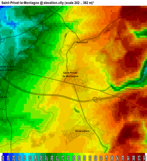
Below is the Elevation map of Saint-Privat-la-Montagne, which displays elevation range with different colors. Scale of the first map is from 202 to 382 m (663 to 1253 ft) with average elevation of 308.8 meters (=1013 ft) [note 1]
These maps also provides idea of topography and contour of this city, they are displayed at different zoom levels. More info about maps, scale and edge coordinates you can find below images.
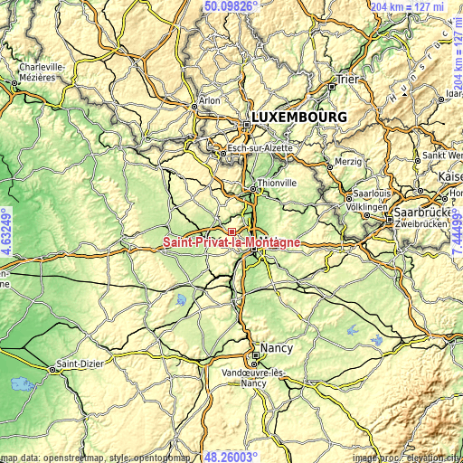
| \ | Map #1 | Topo.Map |
| Scale [m] | 202..382 m | × |
| Scale [ft] | 663..1253 ft | × |
| Average | 308.8 m = 1013 ft | × |
| Width | 6.39 km = 4 mi | 204.4 km = 127 mi |
| Height | 6.39 km = 4 mi | 204.4 km = 127 mi |
| ↑Max Latitude | 49.216394° | 50.09826° |
| Latitude at center | 49.18768° | 49.18768° |
| ↓Min Latitude | 49.15895° | 48.26003° |
| ← Min Longitude | 5.994795° | 4.63249° |
| Longitude center | 6.03874° | 6.03874° |
| →Max Longitude | 6.082685° | 7.44499° |
Nearby cities:
Cities around Saint-Privat-la-Montagne sort by population:
• Moyeuvre-Grande elevation 222 m
7.3 km,  3°
3°
• Jœuf 195 m
5.3 km,  342°
342°
• Homécourt 195 m
5 km,  317°
317°
• Marange-Silvange 217 m
5.3 km,  64°
64°
• Sainte-Marie-aux-Chênes 270 m
2.8 km,  281°
281°
• Auboué 230 m
5.3 km,  300°
300°
• Montois-la-Montagne 280 m
3.5 km, 338°
• Amanvillers 325 m
2.2 km,  170°
170°
• Moutiers 197 m
7.3 km,  313°
313°
• Saulny 210 m
6.1 km,  123°
123°
• Pierrevillers 222 m
6.2 km,  48°
48°
• Batilly 246 m
5.3 km,  253°
253°
Multilingual:
 En español:
Saint-Privat-la-Montagne elevación 323 m.
 En France:
Saint-Privat-la-Montagne élévation 323 m.
 Auf Deutsch:
Saint-Privat-la-Montagne höhe über dem Meeresspiegel ist 323 m.
 На русском:
Сен-Прива-ла-Монтань высота над уровнем моря 323 м
Sources and notes:
- [note 1] Map square and city borders are not equal. Map elevation data is calculated only from area inside that square.
- [src 1] Elevation data from geonames database provided with same terms of usage.
- [src 2] The elevation map of Saint-Privat-la-Montagne is generated using elevation data from NASA's 3 arcsec (90m) resolution SRTM data.
- [src 3] Base (background) map © OpenStreetMap contributors tiles are generated by Geofabrik and OpenTopoMap.
Copyright & License:
This Saint-Privat-la-Montagne Elevation Map is licensed under CC BY-SA. You may reuse any part from this page, if you give a proper credit by linking to this URL:
 More info on terms of use page.