Jonchery-sur-Vesle elevation
Jonchery-sur-Vesle (Grand Est, Marne), France elevation is 80 meters and Jonchery-sur-Vesle elevation in feet is 262 ft above sea level [src 1]. Jonchery-sur-Vesle is a populated place (feature code) with elevation that is 94 meters (308 ft) smaller than average city elevation in France.
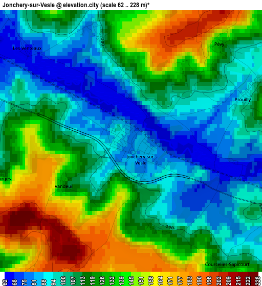
Below is the Elevation map of Jonchery-sur-Vesle, which displays elevation range with different colors. Scale of the first map is from 62 to 228 m (203 to 748 ft) with average elevation of 118.6 meters (=389 ft) [note 1]
These maps also provides idea of topography and contour of this city, they are displayed at different zoom levels. More info about maps, scale and edge coordinates you can find below images.
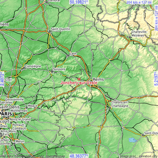
| \ | Map #1 | Topo.Map |
| Scale [m] | 62..228 m | × |
| Scale [ft] | 203..748 ft | × |
| Average | 118.6 m = 389 ft | × |
| Width | 6.37 km = 4 mi | 204 km = 126.8 mi |
| Height | 6.37 km = 4 mi | 204 km = 126.8 mi |
| ↑Max Latitude | 49.318174° | 50.19821° |
| Latitude at center | 49.28952° | 49.28952° |
| ↓Min Latitude | 49.260849° | 48.36377° |
| ← Min Longitude | 3.769505° | 2.4072° |
| Longitude center | 3.81345° | 3.81345° |
| →Max Longitude | 3.857395° | 5.2197° |
Nearby cities:
Cities around Jonchery-sur-Vesle sort by population:
• Reims elevation 90 m
15.8 km,  99°
99°
• Tinqueux 90 m
13.1 km,  109°
109°
• Bétheny 91 m
17.5 km,  91°
91°
• Fismes 74 m
9.5 km,  282°
282°
• Saint-Brice-Courcelles 73 m
12.6 km, 101°
• Muizon 75 m
5.8 km, 106°
• Courcy 80 m
14.2 km,  74°
74°
• Gueux 96 m
8.3 km,  121°
121°
• Bezannes 81 m
14.7 km, 120°
• Hermonville 106 m
8.7 km,  53°
53°
• Loivre 70 m
13.6 km,  62°
62°
• Cormicy 86 m
10.8 km,  33°
33°
Multilingual:
 En español:
Jonchery-sur-Vesle elevación 80 m.
 En France:
Jonchery-sur-Vesle élévation 80 m.
 Auf Deutsch:
Jonchery-sur-Vesle höhe über dem Meeresspiegel ist 80 m.

Sources and notes:
- [note 1] Map square and city borders are not equal. Map elevation data is calculated only from area inside that square.
- [src 1] Elevation data from geonames database provided with same terms of usage.
- [src 2] The elevation map of Jonchery-sur-Vesle is generated using elevation data from NASA's 3 arcsec (90m) resolution SRTM data.
- [src 3] Base (background) map © OpenStreetMap contributors tiles are generated by Geofabrik and OpenTopoMap.
Copyright & License:
This Jonchery-sur-Vesle Elevation Map is licensed under CC BY-SA. You may reuse any part from this page, if you give a proper credit by linking to this URL:
 More info on terms of use page.