La Pomme elevation
La Pomme (Provence-Alpes-Côte d'Azur, Département des Bouches-du-Rhône), France elevation is 43 meters and La Pomme elevation in feet is 141 ft above sea level [src 1]. La Pomme is a section of populated place (feature code) with elevation that is 131 meters (430 ft) smaller than average city elevation in France.
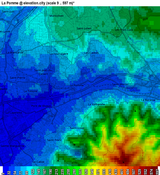
Below is the Elevation map of La Pomme, which displays elevation range with different colors. Scale of the first map is from 9 to 597 m (30 to 1959 ft) with average elevation of 127.4 meters (=418 ft) [note 1]
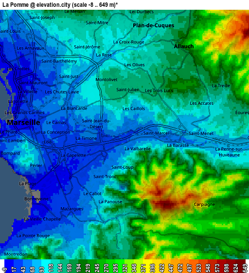
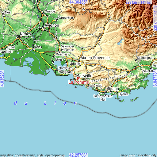
These maps also provides idea of topography and contour of this city, they are displayed at different zoom levels. More info about maps, scale and edge coordinates you can find below images.
| \ | Map #1 | Map #2 | Topo.Map |
| Scale [m] | 9..597 m | -8..649 m | × |
| Scale [ft] | 30..1959 ft | -26..2129 ft | × |
| Average | 127.4 m = 418 ft | 150.3 m = 493 ft | × |
| Width | 7.11 km = 4.4 mi | 14.23 km = 8.8 mi | 227.6 km = 141.4 mi |
| Height | 7.11 km = 4.4 mi | 14.23 km = 8.8 mi | 227.6 km = 141.4 mi |
| ↑Max Latitude | 43.321849° | 43.353811° | 44.30485° |
| Latitude at center | 43.28987° | 43.28987° | 43.28987° |
| ↓Min Latitude | 43.257874° | 43.225861° | 42.25766° |
| ← Min Longitude | 5.397585° | 5.353639° | 4.03528° |
| Longitude center | 5.44153° | 5.44153° | 5.44153° |
| →Max Longitude | 5.485475° | 5.529421° | 6.84778° |
Nearby cities:
Cities around La Pomme sort by population:
• Marseille 12 elevation 89 m
0.8 km,  328°
328°
• Marseille 11 49 m
0.3 km,  290°
290°
• Marseille 10 24 m
2.5 km,  240°
240°
• Saint-Loup 54 m
1.6 km,  211°
211°
• Saint-Tronc 63 m
2.6 km,  215°
215°
• Saint-Barnabé 79 m
2.3 km,  299°
299°
• Saint-Marcel 63 m
2 km,  97°
97°
• La Valbarelle 60 m
1.1 km,  118°
118°
• Les Caillols 90 m
1.5 km,  21°
21°
• La Fourragère 120 m
1.8 km, 332°
• La Timone 36 m
2.2 km,  265°
265°
• Saint-Jean du Désert 69 m
1.7 km,  283°
283°
Multilingual:
 En español:
La Pomme elevación 43 m.
 En France:
La Pomme élévation 43 m.


Sources and notes:
- [note 1] Map square and city borders are not equal. Map elevation data is calculated only from area inside that square.
- [src 1] Elevation data from geonames database provided with same terms of usage.
- [src 2] The elevation map of La Pomme is generated using elevation data from NASA's 3 arcsec (90m) resolution SRTM data.
- [src 3] Base (background) map © OpenStreetMap contributors tiles are generated by Geofabrik and OpenTopoMap.
Copyright & License:
This La Pomme Elevation Map is licensed under CC BY-SA. You may reuse any part from this page, if you give a proper credit by linking to this URL:
 More info on terms of use page.