Marseille 12 elevation
Marseille 12 (Provence-Alpes-Côte d'Azur, Département des Bouches-du-Rhône), France elevation is 89 meters and Marseille 12 elevation in feet is 292 ft above sea level [src 1]. Marseille 12 is a seat of a fifth-order administrative division (feature code) with elevation that is 85 meters (279 ft) smaller than average city elevation in France.
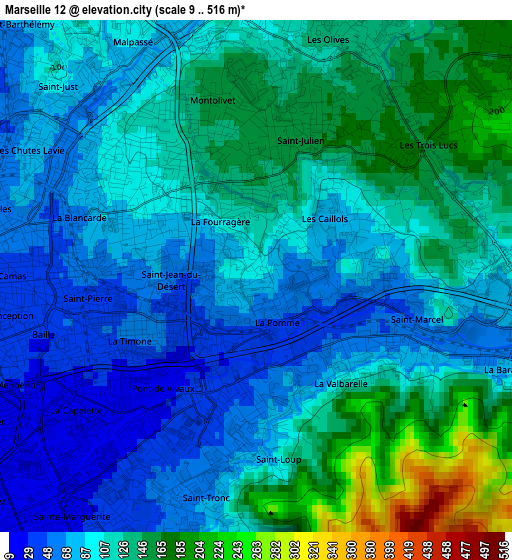
Below is the Elevation map of Marseille 12, which displays elevation range with different colors. Scale of the first map is from 9 to 516 m (30 to 1693 ft) with average elevation of 108.2 meters (=355 ft) [note 1]
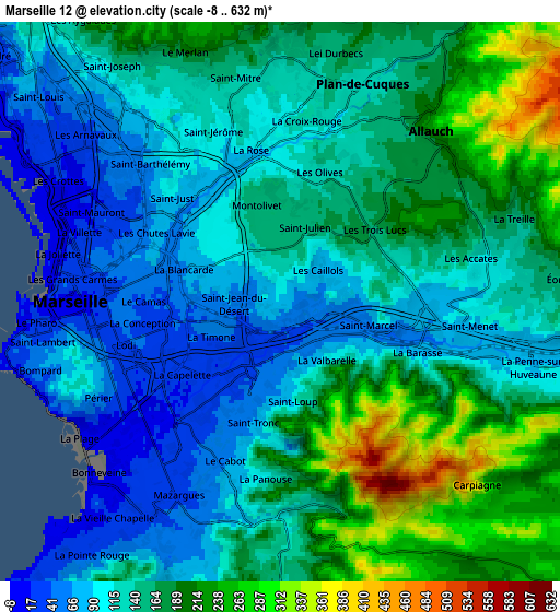
These maps also provides idea of topography and contour of this city, they are displayed at different zoom levels. More info about maps, scale and edge coordinates you can find below images.
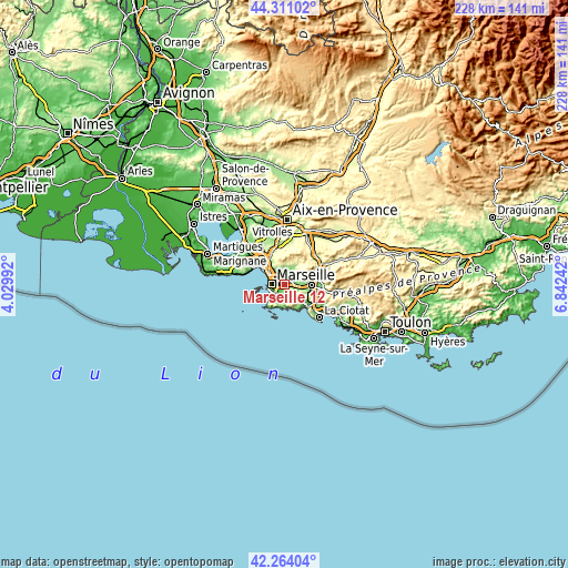
| \ | Map #1 | Map #2 | Topo.Map |
| Scale [m] | 9..516 m | -8..632 m | × |
| Scale [ft] | 30..1693 ft | -26..2073 ft | × |
| Average | 108.2 m = 355 ft | 145.3 m = 477 ft | × |
| Width | 7.11 km = 4.4 mi | 14.23 km = 8.8 mi | 227.6 km = 141.4 mi |
| Height | 7.11 km = 4.4 mi | 14.23 km = 8.8 mi | 227.6 km = 141.4 mi |
| ↑Max Latitude | 43.328116° | 43.360075° | 44.31102° |
| Latitude at center | 43.29614° | 43.29614° | 43.29614° |
| ↓Min Latitude | 43.264147° | 43.232138° | 42.26404° |
| ← Min Longitude | 5.392225° | 5.348279° | 4.02992° |
| Longitude center | 5.43617° | 5.43617° | 5.43617° |
| →Max Longitude | 5.480115° | 5.524061° | 6.84242° |
Nearby cities:
Cities around Marseille 12 sort by population:
• Marseille 11 elevation 49 m
0.6 km,  163°
163°
• La Pomme 43 m
0.8 km,  148°
148°
• Saint-Loup 54 m
2.1 km,  190°
190°
• La Blancarde 80 m
2.5 km,  281°
281°
• Saint-Barnabé 79 m
1.6 km,  285°
285°
• Saint-Julien 164 m
2.2 km,  29°
29°
• La Valbarelle 60 m
1.9 km,  131°
131°
• Les Caillols 90 m
1.2 km,  55°
55°
• Saint-Pierre 54 m
2.4 km,  261°
261°
• La Fourragère 120 m
0.9 km,  335°
335°
• La Timone 36 m
2 km,  244°
244°
• Saint-Jean du Désert 69 m
1.2 km, 255°
Multilingual:
 En español:
Marseille 12 elevación 89 m.
 En France:
Marseille 12 élévation 89 m.
 Auf Deutsch:
Marseille 12 höhe über dem Meeresspiegel ist 89 m.

Sources and notes:
- [note 1] Map square and city borders are not equal. Map elevation data is calculated only from area inside that square.
- [src 1] Elevation data from geonames database provided with same terms of usage.
- [src 2] The elevation map of Marseille 12 is generated using elevation data from NASA's 3 arcsec (90m) resolution SRTM data.
- [src 3] Base (background) map © OpenStreetMap contributors tiles are generated by Geofabrik and OpenTopoMap.
Copyright & License:
This Marseille 12 Elevation Map is licensed under CC BY-SA. You may reuse any part from this page, if you give a proper credit by linking to this URL:
 More info on terms of use page.