Saint-Tronc elevation
Saint-Tronc (Provence-Alpes-Côte d'Azur, Département des Bouches-du-Rhône), France elevation is 63 meters and Saint-Tronc elevation in feet is 207 ft above sea level [src 1]. Saint-Tronc is a section of populated place (feature code) with elevation that is 111 meters (364 ft) smaller than average city elevation in France.
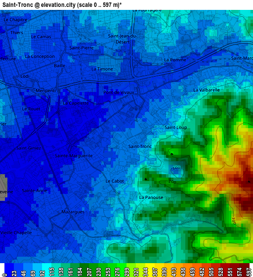
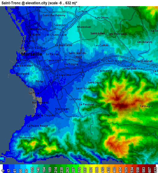
Below is the Elevation map of Saint-Tronc, which displays elevation range with different colors. Scale of the first map is from 0 to 597 m (0 to 1959 ft) with average elevation of 98.9 meters (=324 ft) [note 1]
These maps also provides idea of topography and contour of this city, they are displayed at different zoom levels. More info about maps, scale and edge coordinates you can find below images.
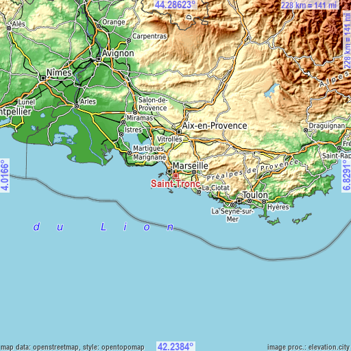
| \ | Map #1 | Map #2 | Topo.Map |
| Scale [m] | 0..597 m | -8..632 m | × |
| Scale [ft] | 0..1959 ft | -26..2073 ft | × |
| Average | 98.9 m = 324 ft | 143.5 m = 471 ft | × |
| Width | 7.12 km = 4.4 mi | 14.23 km = 8.8 mi | 227.7 km = 141.5 mi |
| Height | 7.12 km = 4.4 mi | 14.23 km = 8.8 mi | 227.7 km = 141.5 mi |
| ↑Max Latitude | 43.302919° | 43.334891° | 44.28623° |
| Latitude at center | 43.27093° | 43.27093° | 43.27093° |
| ↓Min Latitude | 43.238924° | 43.206901° | 42.2384° |
| ← Min Longitude | 5.378905° | 5.334959° | 4.0166° |
| Longitude center | 5.42285° | 5.42285° | 5.42285° |
| →Max Longitude | 5.466795° | 5.510741° | 6.8291° |
Nearby cities:
Cities around Saint-Tronc sort by population:
• Marseille 09 elevation 31 m
2.3 km,  216°
216°
• Marseille 11 49 m
2.5 km,  29°
29°
• Marseille 10 24 m
1.1 km,  325°
325°
• Sainte-Marguerite 27 m
2 km,  240°
240°
• Saint-Loup 54 m
1 km,  42°
42°
• Le Cabot 112 m
1.4 km,  198°
198°
• La Capelette 20 m
1.8 km,  308°
308°
• La Panouse 162 m
1.8 km,  161°
161°
• La Timone 36 m
2.1 km,  340°
340°
• Menpenti 20 m
2.5 km,  299°
299°
• Pont de Vivaux 25 m
0.8 km,  315°
315°
• Saint-Jean du Désert 69 m
2.5 km,  357°
357°
Multilingual:
 En español:
Saint-Tronc elevación 63 m.
 En France:
Saint-Tronc élévation 63 m.
 Auf Deutsch:
Saint-Tronc höhe über dem Meeresspiegel ist 63 m.

Sources and notes:
- [note 1] Map square and city borders are not equal. Map elevation data is calculated only from area inside that square.
- [src 1] Elevation data from geonames database provided with same terms of usage.
- [src 2] The elevation map of Saint-Tronc is generated using elevation data from NASA's 3 arcsec (90m) resolution SRTM data.
- [src 3] Base (background) map © OpenStreetMap contributors tiles are generated by Geofabrik and OpenTopoMap.
Copyright & License:
This Saint-Tronc Elevation Map is licensed under CC BY-SA. You may reuse any part from this page, if you give a proper credit by linking to this URL:
 More info on terms of use page.