Le Châtelet elevation
Le Châtelet (Centre, Cher), France elevation is 198 meters and Le Châtelet elevation in feet is 650 ft above sea level [src 1]. Le Châtelet is a populated place (feature code) with elevation that is 24 meters (79 ft) bigger than average city elevation in France.
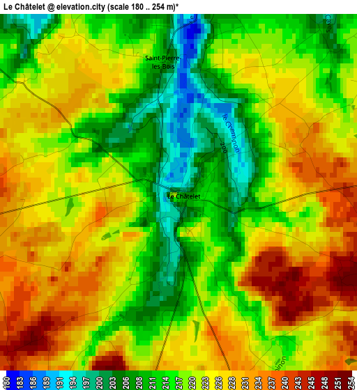
Below is the Elevation map of Le Châtelet, which displays elevation range with different colors. Scale of the first map is from 180 to 254 m (591 to 833 ft) with average elevation of 220.8 meters (=724 ft) [note 1]
These maps also provides idea of topography and contour of this city, they are displayed at different zoom levels. More info about maps, scale and edge coordinates you can find below images.
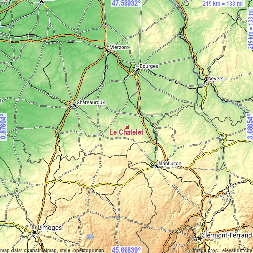
| \ | Map #1 | Topo.Map |
| Scale [m] | 180..254 m | × |
| Scale [ft] | 591..833 ft | × |
| Average | 220.8 m = 724 ft | × |
| Width | 6.71 km = 4.2 mi | 214.7 km = 133.4 mi |
| Height | 6.71 km = 4.2 mi | 214.7 km = 133.4 mi |
| ↑Max Latitude | 46.672632° | 47.59932° |
| Latitude at center | 46.64247° | 46.64247° |
| ↓Min Latitude | 46.612291° | 45.66839° |
| ← Min Longitude | 2.238345° | 0.87604° |
| Longitude center | 2.28229° | 2.28229° |
| →Max Longitude | 2.326235° | 3.68854° |
Nearby cities:
Cities around Le Châtelet sort by population:
• Saint-Amand-Montrond elevation 159 m
19.2 km,  62°
62°
• La Châtre 205 m
23.5 km,  253°
253°
• Châteaumeillant 241 m
11.1 km,  216°
216°
• Orval 168 m
17.1 km, 57°
• Vallon-en-Sully 183 m
27.5 km,  115°
115°
• Montgivray 208 m
23.4 km,  259°
259°
• Lignières 161 m
14.7 km,  325°
325°
• Châteauneuf-sur-Cher 139 m
24.1 km,  6°
6°
• Lunery 131 m
32.6 km,  358°
358°
• Levet 170 m
32.9 km,  16°
16°
• Ainay-le-Château 216 m
32.2 km,  76°
76°
• Charenton-du-Cher 180 m
29.3 km,  70°
70°
Multilingual:
 En español:
Le Châtelet elevación 198 m.
 En France:
Le Châtelet élévation 198 m.
 Auf Deutsch:
Le Châtelet höhe über dem Meeresspiegel ist 198 m.

Sources and notes:
- [note 1] Map square and city borders are not equal. Map elevation data is calculated only from area inside that square.
- [src 1] Elevation data from geonames database provided with same terms of usage.
- [src 2] The elevation map of Le Châtelet is generated using elevation data from NASA's 3 arcsec (90m) resolution SRTM data.
- [src 3] Base (background) map © OpenStreetMap contributors tiles are generated by Geofabrik and OpenTopoMap.
Copyright & License:
This Le Châtelet Elevation Map is licensed under CC BY-SA. You may reuse any part from this page, if you give a proper credit by linking to this URL:
 More info on terms of use page.