Saint-Amand-Montrond elevation
Saint-Amand-Montrond (Centre, Cher), France elevation is 159 meters and Saint-Amand-Montrond elevation in feet is 522 ft above sea level [src 1]. Saint-Amand-Montrond is a seat of a third-order administrative division (feature code) with elevation that is 15 meters (49 ft) smaller than average city elevation in France.
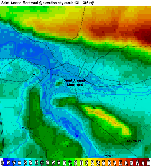
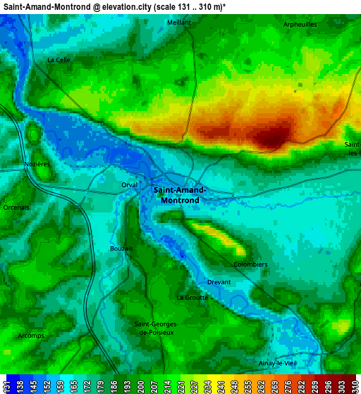
Below is the Elevation map of Saint-Amand-Montrond, which displays elevation range with different colors. Scale of the first map is from 131 to 308 m (430 to 1010 ft) with average elevation of 189.1 meters (=620 ft) [note 1]
These maps also provides idea of topography and contour of this city, they are displayed at different zoom levels. More info about maps, scale and edge coordinates you can find below images.
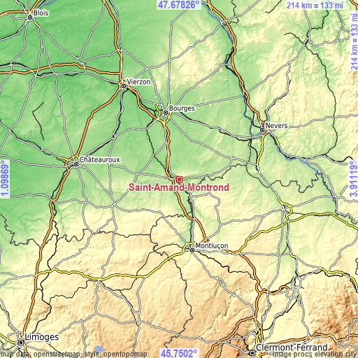
| \ | Map #1 | Map #2 | Topo.Map |
| Scale [m] | 131..308 m | 131..310 m | × |
| Scale [ft] | 430..1010 ft | 430..1017 ft | × |
| Average | 189.1 m = 620 ft | 191.4 m = 628 ft | × |
| Width | 6.7 km = 4.2 mi | 13.4 km = 8.3 mi | 214.4 km = 133.2 mi |
| Height | 6.7 km = 4.2 mi | 13.4 km = 8.3 mi | 214.4 km = 133.2 mi |
| ↑Max Latitude | 46.752957° | 46.783058° | 47.67826° |
| Latitude at center | 46.72284° | 46.72284° | 46.72284° |
| ↓Min Latitude | 46.692706° | 46.662555° | 45.7502° |
| ← Min Longitude | 2.460995° | 2.417049° | 1.09869° |
| Longitude center | 2.50494° | 2.50494° | 2.50494° |
| →Max Longitude | 2.548885° | 2.592831° | 3.91119° |
Nearby cities:
Cities around Saint-Amand-Montrond sort by population:
• Dun-sur-Auron elevation 175 m
18.8 km,  16°
16°
• Châteaumeillant 241 m
29.6 km,  232°
232°
• Orval 168 m
2.6 km,  277°
277°
• Vallon-en-Sully 183 m
22.2 km,  159°
159°
• Lignières 161 m
25.4 km, 277°
• Châteauneuf-sur-Cher 139 m
20.7 km,  316°
316°
• Cérilly 333 m
26.8 km,  115°
115°
• Lunery 131 m
29.7 km, 322°
• Levet 170 m
23.8 km,  341°
341°
• Ainay-le-Château 216 m
14.3 km,  95°
95°
• Le Châtelet 198 m
19.2 km,  242°
242°
• Charenton-du-Cher 180 m
10.7 km,  85°
85°
Multilingual:
 En español:
Saint-Amand-Montrond elevación 159 m.
 En France:
Saint-Amand-Montrond, Saint-Amand-Mont-Rond élévation 159 m.
 Auf Deutsch:
Saint-Amand-Montrond höhe über dem Meeresspiegel ist 159 m.

Sources and notes:
- [note 1] Map square and city borders are not equal. Map elevation data is calculated only from area inside that square.
- [src 1] Elevation data from geonames database provided with same terms of usage.
- [src 2] The elevation map of Saint-Amand-Montrond is generated using elevation data from NASA's 3 arcsec (90m) resolution SRTM data.
- [src 3] Base (background) map © OpenStreetMap contributors tiles are generated by Geofabrik and OpenTopoMap.
Copyright & License:
This Saint-Amand-Montrond Elevation Map is licensed under CC BY-SA. You may reuse any part from this page, if you give a proper credit by linking to this URL:
 More info on terms of use page.