La Châtre elevation
La Châtre (Centre, Département de l'Indre), France elevation is 205 meters and La Châtre elevation in feet is 673 ft above sea level [src 1]. La Châtre is a seat of a third-order administrative division (feature code) with elevation that is 31 meters (102 ft) bigger than average city elevation in France.
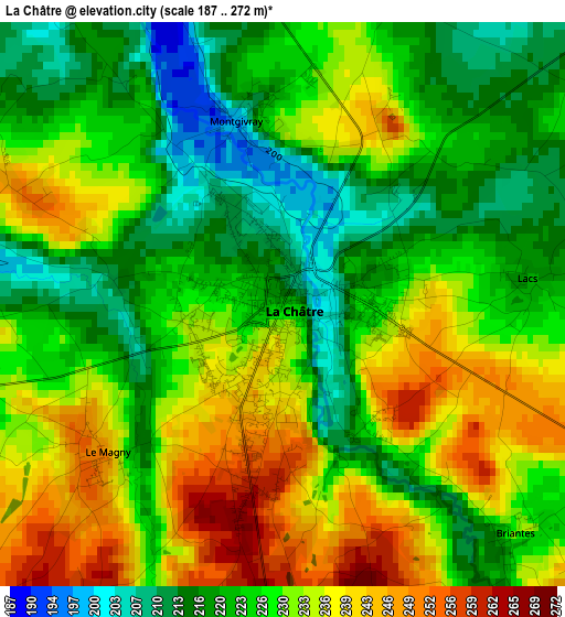
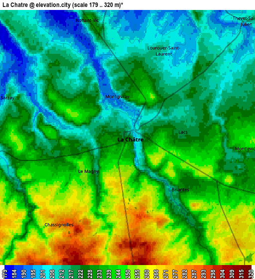
Below is the Elevation map of La Châtre, which displays elevation range with different colors. Scale of the first map is from 187 to 272 m (614 to 892 ft) with average elevation of 227.8 meters (=747 ft) [note 1]
These maps also provides idea of topography and contour of this city, they are displayed at different zoom levels. More info about maps, scale and edge coordinates you can find below images.
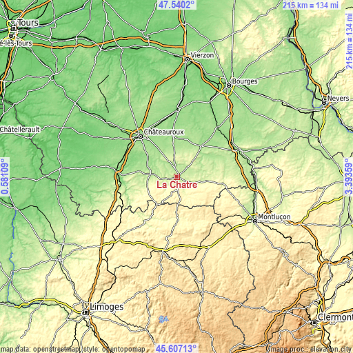
| \ | Map #1 | Map #2 | Topo.Map |
| Scale [m] | 187..272 m | 179..320 m | × |
| Scale [ft] | 614..892 ft | 587..1050 ft | × |
| Average | 227.8 m = 747 ft | 230.9 m = 758 ft | × |
| Width | 6.72 km = 4.2 mi | 13.43 km = 8.3 mi | 214.9 km = 133.5 mi |
| Height | 6.72 km = 4.2 mi | 13.43 km = 8.3 mi | 214.9 km = 133.5 mi |
| ↑Max Latitude | 46.612476° | 46.642655° | 47.5402° |
| Latitude at center | 46.58228° | 46.58228° | 46.58228° |
| ↓Min Latitude | 46.552067° | 46.521838° | 45.60713° |
| ← Min Longitude | 1.943395° | 1.899449° | 0.58109° |
| Longitude center | 1.98734° | 1.98734° | 1.98734° |
| →Max Longitude | 2.031285° | 2.075231° | 3.39359° |
Nearby cities:
Cities around La Châtre sort by population:
• Le Poinçonnet elevation 165 m
28.8 km,  314°
314°
• Ardentes 164 m
21.2 km,  326°
326°
• Châteaumeillant 241 m
16 km,  98°
98°
• Montgivray 208 m
2.4 km,  349°
349°
• Aigurande 435 m
20.4 km,  216°
216°
• Lignières 161 m
23.6 km,  37°
37°
• Neuvy-Saint-Sépulchre 192 m
14 km,  277°
277°
• Boussac 381 m
31.5 km,  145°
145°
• Bonnat 346 m
29 km,  192°
192°
• Le Châtelet 198 m
23.5 km,  73°
73°
• Cluis 280 m
18.7 km,  257°
257°
• Arthon 139 m
25.3 km,  299°
299°
Multilingual:
 En español:
La Châtre elevación 205 m.
 En France:
La Châtre élévation 205 m.
 Auf Deutsch:
La Châtre höhe über dem Meeresspiegel ist 205 m.

Sources and notes:
- [note 1] Map square and city borders are not equal. Map elevation data is calculated only from area inside that square.
- [src 1] Elevation data from geonames database provided with same terms of usage.
- [src 2] The elevation map of La Châtre is generated using elevation data from NASA's 3 arcsec (90m) resolution SRTM data.
- [src 3] Base (background) map © OpenStreetMap contributors tiles are generated by Geofabrik and OpenTopoMap.
Copyright & License:
This La Châtre Elevation Map is licensed under CC BY-SA. You may reuse any part from this page, if you give a proper credit by linking to this URL:
 More info on terms of use page.