Le Monêtier-les-Bains elevation
Le Monêtier-les-Bains (Provence-Alpes-Côte d'Azur, Hautes-Alpes), France elevation is 1705 meters and Le Monêtier-les-Bains elevation in feet is 5594 ft above sea level [src 1]. Le Monêtier-les-Bains is a populated place (feature code) with elevation that is 1531 meters (5023 ft) bigger than average city elevation in France.
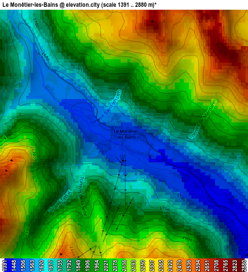
Below is the Elevation map of Le Monêtier-les-Bains, which displays elevation range with different colors. Scale of the first map is from 1391 to 2880 m (4564 to 9449 ft) with average elevation of 1937.9 meters (=6358 ft) [note 1]
These maps also provides idea of topography and contour of this city, they are displayed at different zoom levels. More info about maps, scale and edge coordinates you can find below images.
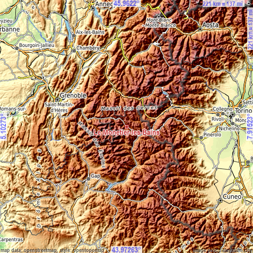
| \ | Map #1 | Topo.Map |
| Scale [m] | 1391..2880 m | × |
| Scale [ft] | 4564..9449 ft | × |
| Average | 1937.9 m = 6358 ft | × |
| Width | 6.91 km = 4.3 mi | 221.2 km = 137.4 mi |
| Height | 6.91 km = 4.3 mi | 221.2 km = 137.4 mi |
| ↑Max Latitude | 45.007119° | 45.9622° |
| Latitude at center | 44.97604° | 44.97604° |
| ↓Min Latitude | 44.944945° | 43.97263° |
| ← Min Longitude | 6.465035° | 5.10273° |
| Longitude center | 6.50898° | 6.50898° |
| →Max Longitude | 6.552925° | 7.91523° |
Nearby cities:
Cities around Le Monêtier-les-Bains sort by population:
• Briançon elevation 1301 m
13.5 km,  129°
129°
• Saint-Jean-de-Maurienne 537 m
35.5 km,  339°
339°
• Modane 1097 m
27.9 km,  26°
26°
• Villeneuve 1395 m
5.6 km, 127°
• Saint-Michel-de-Maurienne 906 m
27.3 km,  353°
353°
• Saint-Chaffrey 1354 m
9.6 km, 125°
• Villar-Saint-Pancrace 1236 m
14.7 km,  140°
140°
• Les Deux Alpes 1655 m
30.4 km,  277°
277°
• Valloire 1404 m
22 km, 343°
• Mont-de-Lans 1269 m
30.4 km, 282°
• Villargondran 589 m
33.7 km, 342°
• Saint-Martin-de-Queyrières 1224 m
17.9 km,  162°
162°
Multilingual:
 En español:
Le Monêtier-les-Bains elevación 1705 m.
 En France:
Le Monêtier-les-Bains élévation 1705 m.
 Auf Deutsch:
Le Monêtier-les-Bains höhe über dem Meeresspiegel ist 1705 m.
 На русском:
Ле-Монетье-ле-Бен высота над уровнем моря 1705 м
Sources and notes:
- [note 1] Map square and city borders are not equal. Map elevation data is calculated only from area inside that square.
- [src 1] Elevation data from geonames database provided with same terms of usage.
- [src 2] The elevation map of Le Monêtier-les-Bains is generated using elevation data from NASA's 3 arcsec (90m) resolution SRTM data.
- [src 3] Base (background) map © OpenStreetMap contributors tiles are generated by Geofabrik and OpenTopoMap.
Copyright & License:
This Le Monêtier-les-Bains Elevation Map is licensed under CC BY-SA. You may reuse any part from this page, if you give a proper credit by linking to this URL:
 More info on terms of use page.