Saint-Jean-de-Maurienne elevation
Saint-Jean-de-Maurienne (Auvergne-Rhône-Alpes, Savoie), France elevation is 537 meters and Saint-Jean-de-Maurienne elevation in feet is 1762 ft above sea level [src 1]. Saint-Jean-de-Maurienne is a seat of a third-order administrative division (feature code) with elevation that is 363 meters (1191 ft) bigger than average city elevation in France.
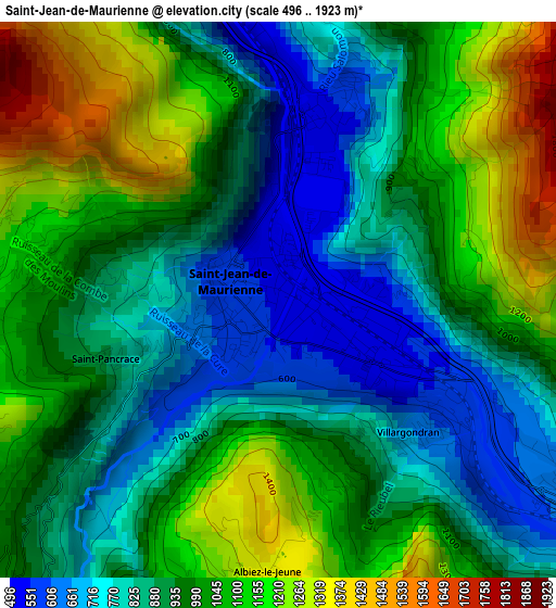
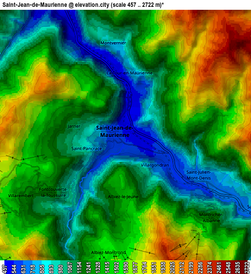
Below is the Elevation map of Saint-Jean-de-Maurienne, which displays elevation range with different colors. Scale of the first map is from 496 to 1923 m (1627 to 6309 ft) with average elevation of 961.9 meters (=3156 ft) [note 1]
These maps also provides idea of topography and contour of this city, they are displayed at different zoom levels. More info about maps, scale and edge coordinates you can find below images.
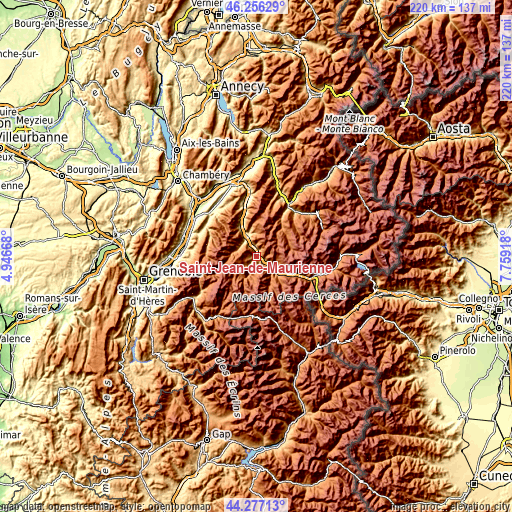
| \ | Map #1 | Map #2 | Topo.Map |
| Scale [m] | 496..1923 m | 457..2722 m | × |
| Scale [ft] | 1627..6309 ft | 1499..8930 ft | × |
| Average | 961.9 m = 3156 ft | 1325 m = 4347 ft | × |
| Width | 6.88 km = 4.3 mi | 13.75 km = 8.5 mi | 220.1 km = 136.8 mi |
| Height | 6.88 km = 4.3 mi | 13.75 km = 8.5 mi | 220.1 km = 136.8 mi |
| ↑Max Latitude | 45.306256° | 45.337155° | 46.25629° |
| Latitude at center | 45.27534° | 45.27534° | 45.27534° |
| ↓Min Latitude | 45.244407° | 45.213458° | 44.27713° |
| ← Min Longitude | 6.308985° | 6.265039° | 4.94668° |
| Longitude center | 6.35293° | 6.35293° | 6.35293° |
| →Max Longitude | 6.396875° | 6.440821° | 7.75918° |
Nearby cities:
Cities around Saint-Jean-de-Maurienne sort by population:
• Allevard elevation 466 m
25.4 km,  301°
301°
• Saint-Martin-de-Belleville 1390 m
16.8 km,  45°
45°
• Saint-Michel-de-Maurienne 906 m
10.9 km,  124°
124°
• Méribel 1424 m
22.7 km, 46°
• Val Thorens 2333 m
18.2 km,  82°
82°
• Les Allues 1115 m
23.6 km,  42°
42°
• Valloire 1404 m
13.6 km,  153°
153°
• Saint-Etienne-de-Cuines 690 m
9.9 km,  326°
326°
• La Chambre 491 m
10.1 km,  335°
335°
• Saint-Rémy-de-Maurienne 494 m
15.4 km, 334°
• Salins-les-Thermes 592 m
25.9 km,  32°
32°
• Villargondran 589 m
2.2 km, 123°
Multilingual:
 En español:
Saint-Jean-de-Maurienne elevación 537 m.
 En France:
Saint-Jean-de-Maurienne élévation 537 m.
 Auf Deutsch:
Saint-Jean-de-Maurienne höhe über dem Meeresspiegel ist 537 m.

Sources and notes:
- [note 1] Map square and city borders are not equal. Map elevation data is calculated only from area inside that square.
- [src 1] Elevation data from geonames database provided with same terms of usage.
- [src 2] The elevation map of Saint-Jean-de-Maurienne is generated using elevation data from NASA's 3 arcsec (90m) resolution SRTM data.
- [src 3] Base (background) map © OpenStreetMap contributors tiles are generated by Geofabrik and OpenTopoMap.
Copyright & License:
This Saint-Jean-de-Maurienne Elevation Map is licensed under CC BY-SA. You may reuse any part from this page, if you give a proper credit by linking to this URL:
 More info on terms of use page.