Leyment elevation
Leyment (Auvergne-Rhône-Alpes, Département de l'Ain), France elevation is 266 meters and Leyment elevation in feet is 873 ft above sea level [src 1]. Leyment is a populated place (feature code) with elevation that is 92 meters (302 ft) bigger than average city elevation in France.
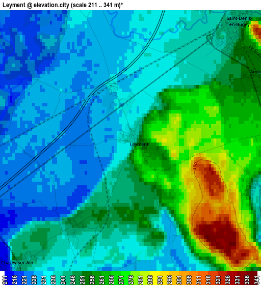
Below is the Elevation map of Leyment, which displays elevation range with different colors. Scale of the first map is from 211 to 341 m (692 to 1119 ft) with average elevation of 245 meters (=804 ft) [note 1]
These maps also provides idea of topography and contour of this city, they are displayed at different zoom levels. More info about maps, scale and edge coordinates you can find below images.
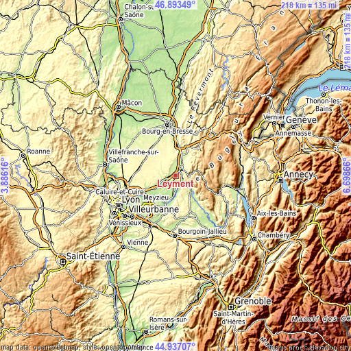
| \ | Map #1 | Topo.Map |
| Scale [m] | 211..341 m | × |
| Scale [ft] | 692..1119 ft | × |
| Average | 245 m = 804 ft | × |
| Width | 6.8 km = 4.2 mi | 217.5 km = 135.1 mi |
| Height | 6.8 km = 4.2 mi | 217.5 km = 135.1 mi |
| ↑Max Latitude | 45.954461° | 46.89349° |
| Latitude at center | 45.9239° | 45.9239° |
| ↓Min Latitude | 45.893323° | 44.93707° |
| ← Min Longitude | 5.248465° | 3.88616° |
| Longitude center | 5.29241° | 5.29241° |
| →Max Longitude | 5.336355° | 6.69866° |
Nearby cities:
Cities around Leyment sort by population:
• Ambérieu-en-Bugey elevation 300 m
6 km,  49°
49°
• Meximieux 218 m
7.4 km,  256°
256°
• Lagnieu 235 m
4.7 km,  120°
120°
• Ambronay 301 m
10.5 km,  31°
31°
• Saint-Denis-en-Bugey 247 m
4 km,  43°
43°
• Château-Gaillard 235 m
5.5 km,  9°
9°
• Châtillon-la-Palud 221 m
6.1 km,  330°
330°
• Chazey-sur-Ain 238 m
4.6 km,  221°
221°
• Priay 233 m
8.7 km,  357°
357°
• Pérouges 229 m
9.2 km, 256°
• Vaux-en-Bugey 344 m
4.6 km,  86°
86°
• Saint-Sorlin-en-Bugey 439 m
7.2 km,  126°
126°
Multilingual:
 En español:
Leyment elevación 266 m.
 En France:
Leyment élévation 266 m.


Sources and notes:
- [note 1] Map square and city borders are not equal. Map elevation data is calculated only from area inside that square.
- [src 1] Elevation data from geonames database provided with same terms of usage.
- [src 2] The elevation map of Leyment is generated using elevation data from NASA's 3 arcsec (90m) resolution SRTM data.
- [src 3] Base (background) map © OpenStreetMap contributors tiles are generated by Geofabrik and OpenTopoMap.
Copyright & License:
This Leyment Elevation Map is licensed under CC BY-SA. You may reuse any part from this page, if you give a proper credit by linking to this URL:
 More info on terms of use page.