Meximieux elevation
Meximieux (Auvergne-Rhône-Alpes, Département de l'Ain), France elevation is 218 meters and Meximieux elevation in feet is 715 ft above sea level [src 1]. Meximieux is a populated place (feature code) with elevation that is 44 meters (144 ft) bigger than average city elevation in France.
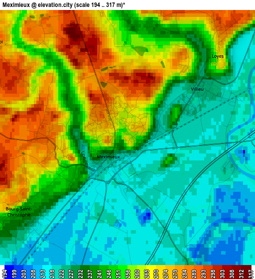
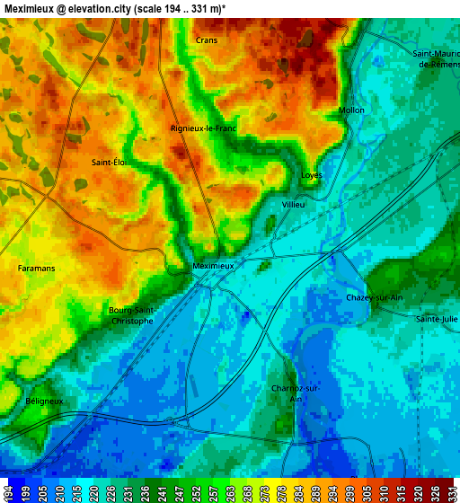
Below is the Elevation map of Meximieux, which displays elevation range with different colors. Scale of the first map is from 194 to 317 m (636 to 1040 ft) with average elevation of 244 meters (=801 ft) [note 1]
These maps also provides idea of topography and contour of this city, they are displayed at different zoom levels. More info about maps, scale and edge coordinates you can find below images.
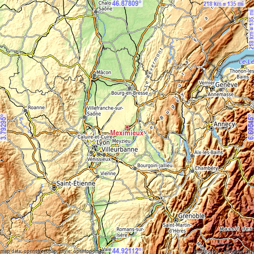
| \ | Map #1 | Map #2 | Topo.Map |
| Scale [m] | 194..317 m | 194..331 m | × |
| Scale [ft] | 636..1040 ft | 636..1086 ft | × |
| Average | 244 m = 801 ft | 246.7 m = 809 ft | × |
| Width | 6.8 km = 4.2 mi | 13.6 km = 8.5 mi | 217.6 km = 135.2 mi |
| Height | 6.8 km = 4.2 mi | 13.6 km = 8.5 mi | 217.6 km = 135.2 mi |
| ↑Max Latitude | 45.938799° | 45.969351° | 46.87809° |
| Latitude at center | 45.90823° | 45.90823° | 45.90823° |
| ↓Min Latitude | 45.877644° | 45.847041° | 44.92112° |
| ← Min Longitude | 5.155255° | 5.111309° | 3.79295° |
| Longitude center | 5.1992° | 5.1992° | 5.1992° |
| →Max Longitude | 5.243145° | 5.287091° | 6.60545° |
Nearby cities:
Cities around Meximieux sort by population:
• Lagnieu elevation 235 m
11.2 km,  93°
93°
• Béligneux 256 m
7.1 km,  230°
230°
• Balan 195 m
11.3 km,  223°
223°
• Saint-Denis-en-Bugey 247 m
11 km,  65°
65°
• Saint-Maurice-de-Gourdans 205 m
9.5 km,  182°
182°
• Chalamont 285 m
10.2 km,  346°
346°
• Château-Gaillard 235 m
10.8 km,  48°
48°
• Châtillon-la-Palud 221 m
8.2 km,  30°
30°
• Saint-Jean-de-Niost 230 m
8.4 km,  170°
170°
• Chazey-sur-Ain 238 m
4.5 km,  111°
111°
• Pérouges 229 m
1.8 km,  256°
256°
• Leyment 266 m
7.4 km,  76°
76°
Multilingual:
 En español:
Meximieux elevación 218 m.
 En France:
Meximieux élévation 218 m.
 Auf Deutsch:
Meximieux höhe über dem Meeresspiegel ist 218 m.

Sources and notes:
- [note 1] Map square and city borders are not equal. Map elevation data is calculated only from area inside that square.
- [src 1] Elevation data from geonames database provided with same terms of usage.
- [src 2] The elevation map of Meximieux is generated using elevation data from NASA's 3 arcsec (90m) resolution SRTM data.
- [src 3] Base (background) map © OpenStreetMap contributors tiles are generated by Geofabrik and OpenTopoMap.
Copyright & License:
This Meximieux Elevation Map is licensed under CC BY-SA. You may reuse any part from this page, if you give a proper credit by linking to this URL:
 More info on terms of use page.