Moislains elevation
Moislains (Hauts-de-France, Somme), France elevation is 70 meters and Moislains elevation in feet is 230 ft above sea level [src 1]. Moislains is a populated place (feature code) with elevation that is 104 meters (341 ft) smaller than average city elevation in France.
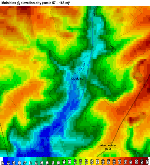
Below is the Elevation map of Moislains, which displays elevation range with different colors. Scale of the first map is from 57 to 163 m (187 to 535 ft) with average elevation of 109.9 meters (=361 ft) [note 1]
These maps also provides idea of topography and contour of this city, they are displayed at different zoom levels. More info about maps, scale and edge coordinates you can find below images.
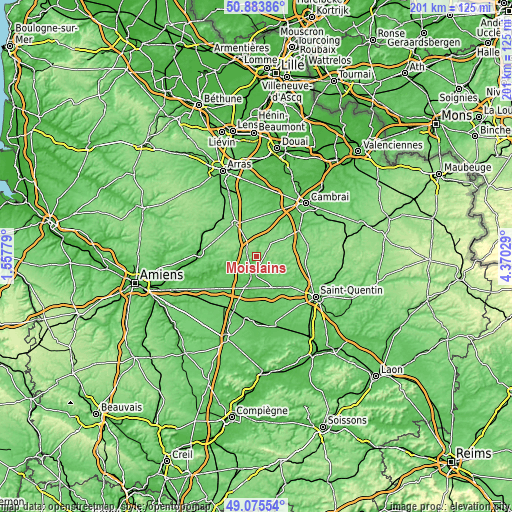
| \ | Map #1 | Topo.Map |
| Scale [m] | 57..163 m | × |
| Scale [ft] | 187..535 ft | × |
| Average | 109.9 m = 361 ft | × |
| Width | 6.28 km = 3.9 mi | 201.1 km = 125 mi |
| Height | 6.28 km = 3.9 mi | 201.1 km = 125 mi |
| ↑Max Latitude | 50.016446° | 50.88386° |
| Latitude at center | 49.9882° | 49.9882° |
| ↓Min Latitude | 49.959937° | 49.07554° |
| ← Min Longitude | 2.920095° | 1.55779° |
| Longitude center | 2.96404° | 2.96404° |
| →Max Longitude | 3.007985° | 4.37029° |
Nearby cities:
Cities around Moislains sort by population:
• Péronne elevation 51 m
6.5 km,  197°
197°
• Bapaume 124 m
15.2 km,  327°
327°
• Roisel 84 m
10.7 km,  114°
114°
• Marcoing 56 m
21 km,  45°
45°
• Doingt 58 m
7.5 km,  178°
178°
• Bray-sur-Somme 48 m
18.3 km,  253°
253°
• Gouzeaucourt 123 m
13.7 km,  56°
56°
• Hermies 115 m
14.8 km,  22°
22°
• Vaulx-Vraucourt 91 m
18.3 km,  347°
347°
• Épehy 134 m
12.2 km,  83°
83°
• Vermand 89 m
18.3 km,  133°
133°
• Achiet-le-Grand 120 m
20.5 km,  320°
320°
Multilingual:
 En español:
Moislains elevación 70 m.
 En France:
Moislains élévation 70 m.
 Auf Deutsch:
Moislains höhe über dem Meeresspiegel ist 70 m.

Sources and notes:
- [note 1] Map square and city borders are not equal. Map elevation data is calculated only from area inside that square.
- [src 1] Elevation data from geonames database provided with same terms of usage.
- [src 2] The elevation map of Moislains is generated using elevation data from NASA's 3 arcsec (90m) resolution SRTM data.
- [src 3] Base (background) map © OpenStreetMap contributors tiles are generated by Geofabrik and OpenTopoMap.
Copyright & License:
This Moislains Elevation Map is licensed under CC BY-SA. You may reuse any part from this page, if you give a proper credit by linking to this URL:
 More info on terms of use page.