Montbard elevation
Montbard (Bourgogne-Franche-Comté, Département de la Côte-d'Or), France elevation is 214 meters and Montbard elevation in feet is 702 ft above sea level [src 1]. Montbard is a seat of a third-order administrative division (feature code) with elevation that is 40 meters (131 ft) bigger than average city elevation in France.
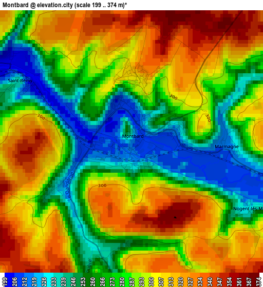
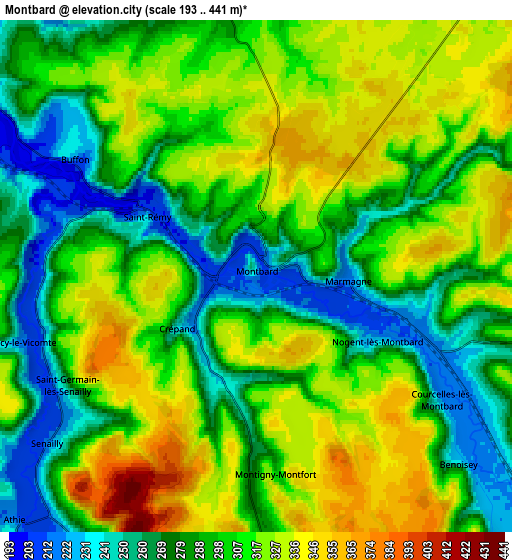
Below is the Elevation map of Montbard, which displays elevation range with different colors. Scale of the first map is from 199 to 374 m (653 to 1227 ft) with average elevation of 288 meters (=945 ft) [note 1]
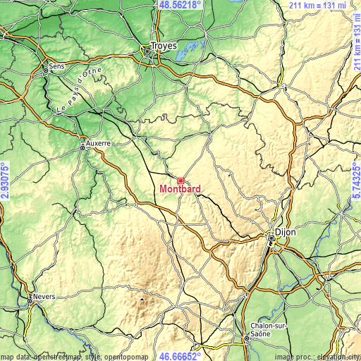
These maps also provides idea of topography and contour of this city, they are displayed at different zoom levels. More info about maps, scale and edge coordinates you can find below images.
| \ | Map #1 | Map #2 | Topo.Map |
| Scale [m] | 199..374 m | 193..441 m | × |
| Scale [ft] | 653..1227 ft | 633..1447 ft | × |
| Average | 288 m = 945 ft | 300.8 m = 987 ft | × |
| Width | 6.59 km = 4.1 mi | 13.17 km = 8.2 mi | 210.8 km = 131 mi |
| Height | 6.59 km = 4.1 mi | 13.17 km = 8.2 mi | 210.8 km = 131 mi |
| ↑Max Latitude | 47.652551° | 47.682145° | 48.56218° |
| Latitude at center | 47.62294° | 47.62294° | 47.62294° |
| ↓Min Latitude | 47.593312° | 47.563668° | 46.66652° |
| ← Min Longitude | 4.293055° | 4.249109° | 2.93075° |
| Longitude center | 4.337° | 4.337° | 4.337° |
| →Max Longitude | 4.380945° | 4.424891° | 5.74325° |
Nearby cities:
Cities around Montbard sort by population:
• Avallon elevation 246 m
35.4 km,  245°
245°
• Châtillon-sur-Seine 220 m
31.6 km,  34°
34°
• Tonnerre 145 m
37.6 km,  313°
313°
• Semur-en-Auxois 264 m
15.5 km,  181°
181°
• Venarey-les-Laumes 235 m
12.9 km,  134°
134°
• Saulieu 537 m
39 km,  192°
192°
• Mussy-sur-Seine 191 m
41.2 km,  16°
16°
• Vitteaux 316 m
29.4 km,  148°
148°
• Tanlay 159 m
31 km,  322°
322°
• Joux-la-Ville 227 m
35.6 km,  269°
269°
• Ancy-le-Franc 183 m
21.4 km, 322°
• Ravières 191 m
14.9 km,  326°
326°
Multilingual:
 En español:
Montbard elevación 214 m.
 En France:
Montbard élévation 214 m.
 Auf Deutsch:
Montbard höhe über dem Meeresspiegel ist 214 m.

Sources and notes:
- [note 1] Map square and city borders are not equal. Map elevation data is calculated only from area inside that square.
- [src 1] Elevation data from geonames database provided with same terms of usage.
- [src 2] The elevation map of Montbard is generated using elevation data from NASA's 3 arcsec (90m) resolution SRTM data.
- [src 3] Base (background) map © OpenStreetMap contributors tiles are generated by Geofabrik and OpenTopoMap.
Copyright & License:
This Montbard Elevation Map is licensed under CC BY-SA. You may reuse any part from this page, if you give a proper credit by linking to this URL:
 More info on terms of use page.