Châtillon-sur-Seine elevation
Châtillon-sur-Seine (Bourgogne-Franche-Comté, Département de la Côte-d'Or), France elevation is 220 meters and Châtillon-sur-Seine elevation in feet is 722 ft above sea level [src 1]. Châtillon-sur-Seine is a populated place (feature code) with elevation that is 46 meters (151 ft) bigger than average city elevation in France.
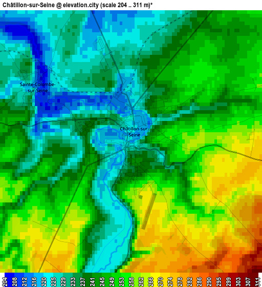
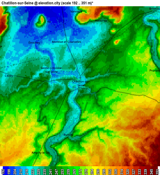
Below is the Elevation map of Châtillon-sur-Seine, which displays elevation range with different colors. Scale of the first map is from 204 to 311 m (669 to 1020 ft) with average elevation of 244.7 meters (=803 ft) [note 1]
These maps also provides idea of topography and contour of this city, they are displayed at different zoom levels. More info about maps, scale and edge coordinates you can find below images.
| \ | Map #1 | Map #2 | Topo.Map |
| Scale [m] | 204..311 m | 192..351 m | × |
| Scale [ft] | 669..1020 ft | 630..1152 ft | × |
| Average | 244.7 m = 803 ft | 258 m = 846 ft | × |
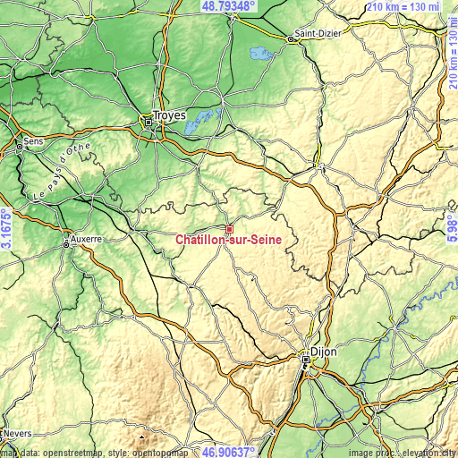
| Width | 6.56 km = 4.1 mi | 13.11 km = 8.1 mi | 209.8 km = 130.4 mi |
| Height | 6.56 km = 4.1 mi | 13.11 km = 8.1 mi | 209.8 km = 130.4 mi |
| ↑Max Latitude | 47.887987° | 47.917448° | 48.79348° |
| Latitude at center | 47.85851° | 47.85851° | 47.85851° |
| ↓Min Latitude | 47.829016° | 47.799505° | 46.90637° |
| ← Min Longitude | 4.529805° | 4.485859° | 3.1675° |
| Longitude center | 4.57375° | 4.57375° | 4.57375° |
| →Max Longitude | 4.617695° | 4.661641° | 5.98° |
Nearby cities:
Cities around Châtillon-sur-Seine sort by population:
• Montbard elevation 214 m
31.6 km,  214°
214°
• Bar-sur-Aube 168 m
42.8 km,  13°
13°
• Bar-sur-Seine 151 m
31.9 km,  332°
332°
• Venarey-les-Laumes 235 m
36.2 km,  193°
193°
• Châteauvillain 236 m
32.4 km,  52°
52°
• Les Riceys 178 m
21.4 km,  314°
314°
• Mussy-sur-Seine 191 m
14.4 km,  336°
336°
• Ville-sous-la-Ferté 202 m
33.3 km,  28°
28°
• Tanlay 159 m
36.5 km,  267°
267°
• Chaource 147 m
39.4 km,  304°
304°
• Ancy-le-Franc 183 m
32 km,  253°
253°
• Ravières 191 m
29.3 km,  241°
241°
Multilingual:
 En español:
Châtillon-sur-Seine elevación 220 m.
 En France:
Châtillon-sur-Seine élévation 220 m.
 Auf Deutsch:
Châtillon-sur-Seine höhe über dem Meeresspiegel ist 220 m.

Sources and notes:
- [note 1] Map square and city borders are not equal. Map elevation data is calculated only from area inside that square.
- [src 1] Elevation data from geonames database provided with same terms of usage.
- [src 2] The elevation map of Châtillon-sur-Seine is generated using elevation data from NASA's 3 arcsec (90m) resolution SRTM data.
- [src 3] Base (background) map © OpenStreetMap contributors tiles are generated by Geofabrik and OpenTopoMap.
Copyright & License:
This Châtillon-sur-Seine Elevation Map is licensed under CC BY-SA. You may reuse any part from this page, if you give a proper credit by linking to this URL:
 More info on terms of use page.