Montrevel-en-Bresse elevation
Montrevel-en-Bresse (Auvergne-Rhône-Alpes, Département de l'Ain), France elevation is 212 meters and Montrevel-en-Bresse elevation in feet is 696 ft above sea level [src 1]. Montrevel-en-Bresse is a populated place (feature code) with elevation that is 38 meters (125 ft) bigger than average city elevation in France.
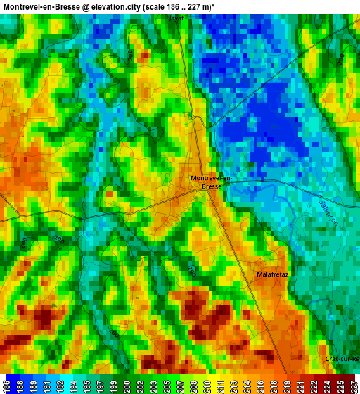
Below is the Elevation map of Montrevel-en-Bresse, which displays elevation range with different colors. Scale of the first map is from 186 to 227 m (610 to 745 ft) with average elevation of 203.6 meters (=668 ft) [note 1]
These maps also provides idea of topography and contour of this city, they are displayed at different zoom levels. More info about maps, scale and edge coordinates you can find below images.
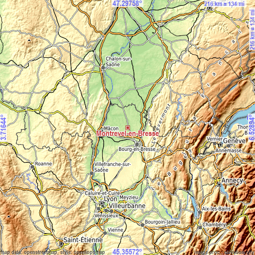
| \ | Map #1 | Topo.Map |
| Scale [m] | 186..227 m | × |
| Scale [ft] | 610..745 ft | × |
| Average | 203.6 m = 668 ft | × |
| Width | 6.75 km = 4.2 mi | 215.9 km = 134.2 mi |
| Height | 6.75 km = 4.2 mi | 215.9 km = 134.2 mi |
| ↑Max Latitude | 46.365603° | 47.29758° |
| Latitude at center | 46.33527° | 46.33527° |
| ↓Min Latitude | 46.30492° | 45.35572° |
| ← Min Longitude | 5.078745° | 3.71644° |
| Longitude center | 5.12269° | 5.12269° |
| →Max Longitude | 5.166635° | 6.52894° |
Nearby cities:
Cities around Montrevel-en-Bresse sort by population:
• Viriat elevation 227 m
11.4 km,  141°
141°
• Saint-Denis-lès-Bourg 235 m
15.7 km,  160°
160°
• Bâgé-la-Ville 206 m
14.1 km,  261°
261°
• Marboz 220 m
10.4 km,  85°
85°
• Saint-Étienne-du-Bois 248 m
14.1 km,  110°
110°
• Polliat 225 m
9.7 km,  178°
178°
• Attignat 203 m
6.3 km,  151°
151°
• Mézériat 208 m
12.4 km,  208°
208°
• Foissiat 220 m
5.7 km,  45°
45°
• Buellas 222 m
13.8 km, 176°
• Saint-Cyr-sur-Menthon 209 m
13.3 km,  239°
239°
• Saint-Trivier-de-Courtes 213 m
14.3 km,  345°
345°
Multilingual:
 En español:
Montrevel-en-Bresse elevación 212 m.
 En France:
Montrevel-en-Bresse élévation 212 m.
 Auf Deutsch:
Montrevel-en-Bresse höhe über dem Meeresspiegel ist 212 m.
 На русском:
Montrevel-en-Bresse высота над уровнем моря 212 м
Sources and notes:
- [note 1] Map square and city borders are not equal. Map elevation data is calculated only from area inside that square.
- [src 1] Elevation data from geonames database provided with same terms of usage.
- [src 2] The elevation map of Montrevel-en-Bresse is generated using elevation data from NASA's 3 arcsec (90m) resolution SRTM data.
- [src 3] Base (background) map © OpenStreetMap contributors tiles are generated by Geofabrik and OpenTopoMap.
Copyright & License:
This Montrevel-en-Bresse Elevation Map is licensed under CC BY-SA. You may reuse any part from this page, if you give a proper credit by linking to this URL:
 More info on terms of use page.