Saint-Cyr-sur-Menthon elevation
Saint-Cyr-sur-Menthon (Auvergne-Rhône-Alpes, Département de l'Ain), France elevation is 209 meters and Saint-Cyr-sur-Menthon elevation in feet is 686 ft above sea level [src 1]. Saint-Cyr-sur-Menthon is a populated place (feature code) with elevation that is 35 meters (115 ft) bigger than average city elevation in France.
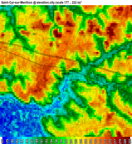
Below is the Elevation map of Saint-Cyr-sur-Menthon, which displays elevation range with different colors. Scale of the first map is from 177 to 222 m (581 to 728 ft) with average elevation of 200.1 meters (=656 ft) [note 1]
These maps also provides idea of topography and contour of this city, they are displayed at different zoom levels. More info about maps, scale and edge coordinates you can find below images.
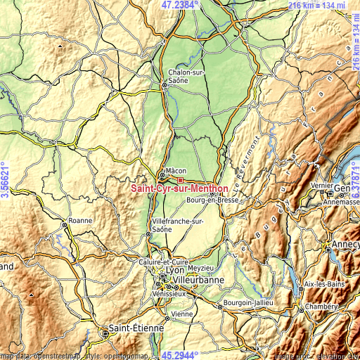
| \ | Map #1 | Topo.Map |
| Scale [m] | 177..222 m | × |
| Scale [ft] | 581..728 ft | × |
| Average | 200.1 m = 656 ft | × |
| Width | 6.75 km = 4.2 mi | 216.2 km = 134.3 mi |
| Height | 6.75 km = 4.2 mi | 216.1 km = 134.3 mi |
| ↑Max Latitude | 46.305386° | 47.2384° |
| Latitude at center | 46.27502° | 46.27502° |
| ↓Min Latitude | 46.244637° | 45.2944° |
| ← Min Longitude | 4.928515° | 3.56621° |
| Longitude center | 4.97246° | 4.97246° |
| →Max Longitude | 5.016405° | 6.37871° |
Nearby cities:
Cities around Saint-Cyr-sur-Menthon sort by population:
• Replonges elevation 187 m
7.4 km,  292°
292°
• Feillens 186 m
9.1 km,  316°
316°
• Vonnas 190 m
6.6 km,  166°
166°
• Bâgé-la-Ville 206 m
5.1 km,  331°
331°
• Mézériat 208 m
7.1 km,  126°
126°
• Saint-Laurent-sur-Saône 178 m
10.6 km, 288°
• Grièges 182 m
9.8 km,  257°
257°
• Manziat 201 m
10.9 km, 331°
• Pont-de-Veyle 177 m
6.8 km, 257°
• Crottet 206 m
6 km,  271°
271°
• Laiz 179 m
6.9 km,  246°
246°
• Saint-Jean-sur-Veyle 182 m
4.6 km, 247°
Multilingual:
 En español:
Saint-Cyr-sur-Menthon elevación 209 m.
 En France:
Saint-Cyr-sur-Menthon élévation 209 m.
 Auf Deutsch:
Saint-Cyr-sur-Menthon höhe über dem Meeresspiegel ist 209 m.
 На русском:
Сен-Сир-сюр-Мантон высота над уровнем моря 209 м
Sources and notes:
- [note 1] Map square and city borders are not equal. Map elevation data is calculated only from area inside that square.
- [src 1] Elevation data from geonames database provided with same terms of usage.
- [src 2] The elevation map of Saint-Cyr-sur-Menthon is generated using elevation data from NASA's 3 arcsec (90m) resolution SRTM data.
- [src 3] Base (background) map © OpenStreetMap contributors tiles are generated by Geofabrik and OpenTopoMap.
Copyright & License:
This Saint-Cyr-sur-Menthon Elevation Map is licensed under CC BY-SA. You may reuse any part from this page, if you give a proper credit by linking to this URL:
 More info on terms of use page.