Viriat elevation
Viriat (Auvergne-Rhône-Alpes, Département de l'Ain), France elevation is 227 meters and Viriat elevation in feet is 745 ft above sea level [src 1]. Viriat is a populated place (feature code) with elevation that is 53 meters (174 ft) bigger than average city elevation in France.
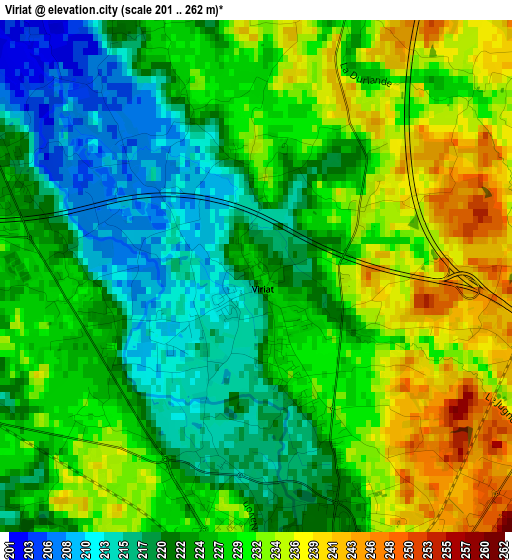
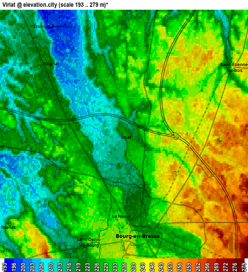
Below is the Elevation map of Viriat, which displays elevation range with different colors. Scale of the first map is from 201 to 262 m (659 to 860 ft) with average elevation of 226.5 meters (=743 ft) [note 1]
These maps also provides idea of topography and contour of this city, they are displayed at different zoom levels. More info about maps, scale and edge coordinates you can find below images.
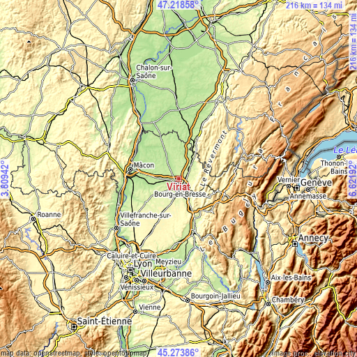
| \ | Map #1 | Map #2 | Topo.Map |
| Scale [m] | 201..262 m | 193..279 m | × |
| Scale [ft] | 659..860 ft | 633..915 ft | × |
| Average | 226.5 m = 743 ft | 229.9 m = 754 ft | × |
| Width | 6.76 km = 4.2 mi | 13.51 km = 8.4 mi | 216.2 km = 134.3 mi |
| Height | 6.76 km = 4.2 mi | 13.51 km = 8.4 mi | 216.2 km = 134.3 mi |
| ↑Max Latitude | 46.285218° | 46.315578° | 47.21858° |
| Latitude at center | 46.25484° | 46.25484° | 46.25484° |
| ↓Min Latitude | 46.224446° | 46.194034° | 45.27386° |
| ← Min Longitude | 5.171725° | 5.127779° | 3.80942° |
| Longitude center | 5.21567° | 5.21567° | 5.21567° |
| →Max Longitude | 5.259615° | 5.303561° | 6.62192° |
Nearby cities:
Cities around Viriat sort by population:
• Bourg-en-Bresse elevation 231 m
5.5 km,  171°
171°
• Péronnas 240 m
8 km,  182°
182°
• Saint-Denis-lès-Bourg 235 m
6.2 km,  199°
199°
• Ceyzériat 325 m
11.4 km,  135°
135°
• Marboz 220 m
10.3 km,  18°
18°
• Saint-Étienne-du-Bois 248 m
7.2 km,  57°
57°
• Polliat 225 m
6.9 km,  264°
264°
• Attignat 203 m
5.4 km,  309°
309°
• Buellas 222 m
8.1 km,  232°
232°
• Montagnat 245 m
11.2 km,  150°
150°
• Jasseron 294 m
9.7 km,  118°
118°
• Meillonnas 274 m
10.4 km,  96°
96°
Multilingual:
 En español:
Viriat elevación 227 m.
 En France:
Viriat élévation 227 m.


Sources and notes:
- [note 1] Map square and city borders are not equal. Map elevation data is calculated only from area inside that square.
- [src 1] Elevation data from geonames database provided with same terms of usage.
- [src 2] The elevation map of Viriat is generated using elevation data from NASA's 3 arcsec (90m) resolution SRTM data.
- [src 3] Base (background) map © OpenStreetMap contributors tiles are generated by Geofabrik and OpenTopoMap.
Copyright & License:
This Viriat Elevation Map is licensed under CC BY-SA. You may reuse any part from this page, if you give a proper credit by linking to this URL:
 More info on terms of use page.