Monts elevation
Monts (Centre, Département d'Indre-et-Loire), France elevation is 57 meters and Monts elevation in feet is 187 ft above sea level [src 1]. Monts is a populated place (feature code) with elevation that is 117 meters (384 ft) smaller than average city elevation in France.
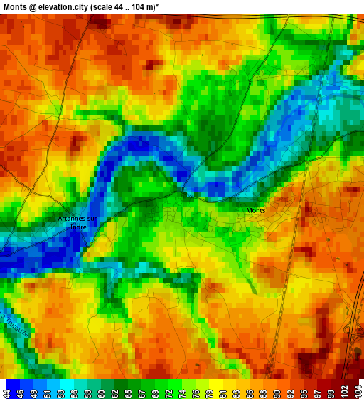
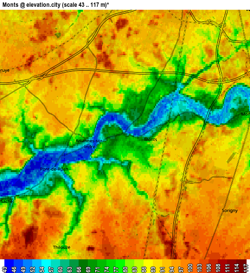
Below is the Elevation map of Monts, which displays elevation range with different colors. Scale of the first map is from 44 to 104 m (144 to 341 ft) with average elevation of 77.4 meters (=254 ft) [note 1]
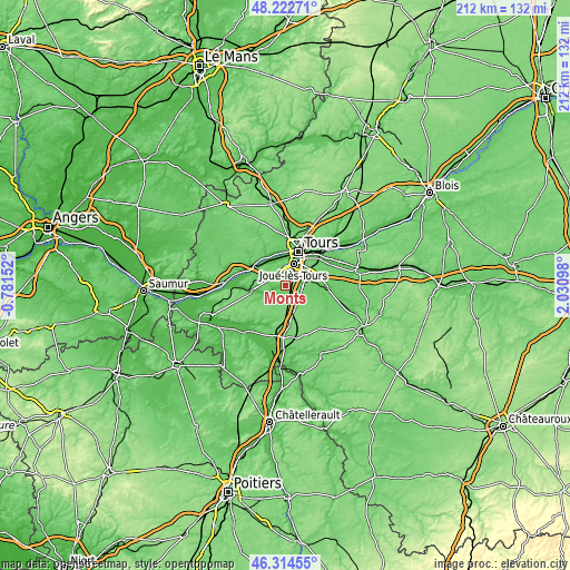
These maps also provides idea of topography and contour of this city, they are displayed at different zoom levels. More info about maps, scale and edge coordinates you can find below images.
| \ | Map #1 | Map #2 | Topo.Map |
| Scale [m] | 44..104 m | 43..117 m | × |
| Scale [ft] | 144..341 ft | 141..384 ft | × |
| Average | 77.4 m = 254 ft | 86.5 m = 284 ft | × |
| Width | 6.63 km = 4.1 mi | 13.26 km = 8.2 mi | 212.2 km = 131.9 mi |
| Height | 6.63 km = 4.1 mi | 13.26 km = 8.2 mi | 212.2 km = 131.9 mi |
| ↑Max Latitude | 47.307036° | 47.336826° | 48.22271° |
| Latitude at center | 47.27723° | 47.27723° | 47.27723° |
| ↓Min Latitude | 47.247407° | 47.217567° | 46.31455° |
| ← Min Longitude | 0.580785° | 0.536839° | -0.78152° |
| Longitude center | 0.62473° | 0.62473° | 0.62473° |
| →Max Longitude | 0.668675° | 0.712621° | 2.03098° |
Nearby cities:
Cities around Monts sort by population:
• Joué-lès-Tours elevation 83 m
9 km,  21°
21°
• Chambray-lès-Tours 89 m
8.7 km,  42°
42°
• Ballan-Miré 92 m
7.1 km,  353°
353°
• Veigné 73 m
8.8 km,  83°
83°
• Montbazon 66 m
5.7 km, 83°
• Azay-le-Rideau 86 m
11.7 km,  262°
262°
• Savonnières 62 m
9.7 km,  324°
324°
• Artannes-sur-Indre 53 m
1.9 km, 260°
• Sorigny 97 m
6.5 km,  125°
125°
• Thilouze 81 m
6.8 km,  209°
209°
• Villandry 47 m
11.1 km,  309°
309°
• Saché 61 m
6.9 km,  241°
241°
Multilingual:
 En español:
Monts elevación 57 m.
 En France:
Monts élévation 57 m.


Sources and notes:
- [note 1] Map square and city borders are not equal. Map elevation data is calculated only from area inside that square.
- [src 1] Elevation data from geonames database provided with same terms of usage.
- [src 2] The elevation map of Monts is generated using elevation data from NASA's 3 arcsec (90m) resolution SRTM data.
- [src 3] Base (background) map © OpenStreetMap contributors tiles are generated by Geofabrik and OpenTopoMap.
Copyright & License:
This Monts Elevation Map is licensed under CC BY-SA. You may reuse any part from this page, if you give a proper credit by linking to this URL:
 More info on terms of use page.