Péroy-les-Gombries elevation
Péroy-les-Gombries (Hauts-de-France, Département de l'Oise), France elevation is 130 meters and Péroy-les-Gombries elevation in feet is 427 ft above sea level [src 1]. Péroy-les-Gombries is a populated place (feature code) with elevation that is 44 meters (144 ft) smaller than average city elevation in France.
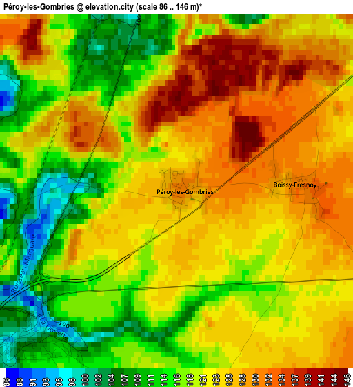
Below is the Elevation map of Péroy-les-Gombries, which displays elevation range with different colors. Scale of the first map is from 86 to 146 m (282 to 479 ft) with average elevation of 121.4 meters (=398 ft) [note 1]
These maps also provides idea of topography and contour of this city, they are displayed at different zoom levels. More info about maps, scale and edge coordinates you can find below images.
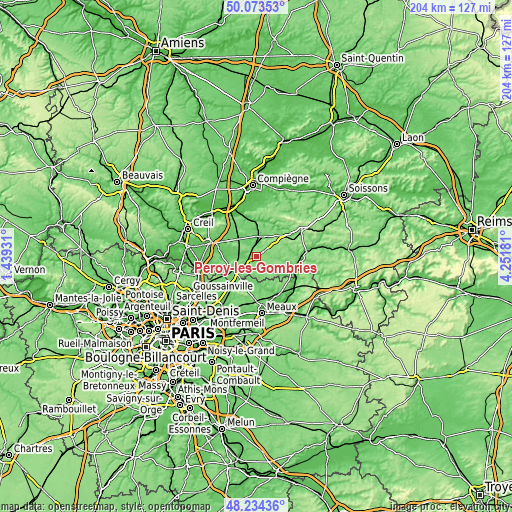
| \ | Map #1 | Topo.Map |
| Scale [m] | 86..146 m | × |
| Scale [ft] | 282..479 ft | × |
| Average | 121.4 m = 398 ft | × |
| Width | 6.39 km = 4 mi | 204.5 km = 127.1 mi |
| Height | 6.39 km = 4 mi | 204.5 km = 127.1 mi |
| ↑Max Latitude | 49.191208° | 50.07353° |
| Latitude at center | 49.16248° | 49.16248° |
| ↓Min Latitude | 49.133735° | 48.23436° |
| ← Min Longitude | 2.801615° | 1.43931° |
| Longitude center | 2.84556° | 2.84556° |
| →Max Longitude | 2.889505° | 4.25181° |
Nearby cities:
Cities around Péroy-les-Gombries sort by population:
• Crépy-en-Valois elevation 98 m
8.5 km,  21°
21°
• Saint-Pathus 101 m
10.7 km,  198°
198°
• Nanteuil-le-Haudouin 92 m
3.5 km,  225°
225°
• Saint-Soupplets 105 m
14 km,  191°
191°
• Le Plessis-Belleville 115 m
9.9 km,  220°
220°
• Oissery 92 m
10.4 km, 191°
• Lagny-le-Sec 107 m
11.1 km, 221°
• Béthisy-Saint-Martin 48 m
14.9 km,  352°
352°
• Silly-le-Long 125 m
7.2 km,  212°
212°
• Ver-sur-Launette 94 m
13.4 km,  241°
241°
• Betz 96 m
8.1 km,  95°
95°
• Vaumoise 106 m
12.7 km,  50°
50°
Multilingual:
 En español:
Péroy-les-Gombries elevación 130 m.
 En France:
Péroy-les-Gombries élévation 130 m.
 Auf Deutsch:
Péroy-les-Gombries höhe über dem Meeresspiegel ist 130 m.
 На русском:
Péroy-les-Gombries высота над уровнем моря 130 м
Sources and notes:
- [note 1] Map square and city borders are not equal. Map elevation data is calculated only from area inside that square.
- [src 1] Elevation data from geonames database provided with same terms of usage.
- [src 2] The elevation map of Péroy-les-Gombries is generated using elevation data from NASA's 3 arcsec (90m) resolution SRTM data.
- [src 3] Base (background) map © OpenStreetMap contributors tiles are generated by Geofabrik and OpenTopoMap.
Copyright & License:
This Péroy-les-Gombries Elevation Map is licensed under CC BY-SA. You may reuse any part from this page, if you give a proper credit by linking to this URL:
 More info on terms of use page.