Pertuis elevation
Pertuis (Provence-Alpes-Côte d'Azur, Département du Vaucluse), France elevation is 220 meters and Pertuis elevation in feet is 722 ft above sea level [src 1]. Pertuis is a populated place (feature code) with elevation that is 46 meters (151 ft) bigger than average city elevation in France.
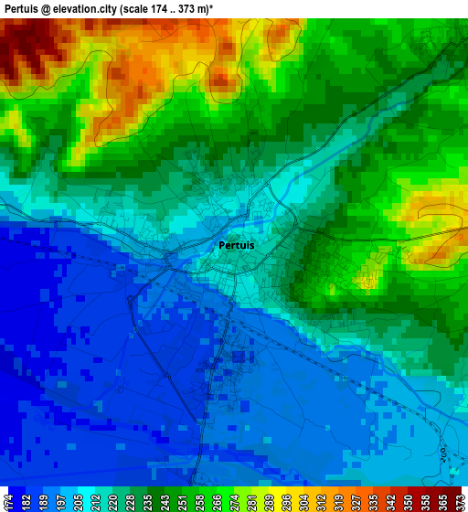
Below is the Elevation map of Pertuis, which displays elevation range with different colors. Scale of the first map is from 174 to 373 m (571 to 1224 ft) with average elevation of 228.3 meters (=749 ft) [note 1]
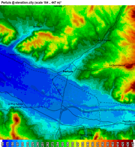
These maps also provides idea of topography and contour of this city, they are displayed at different zoom levels. More info about maps, scale and edge coordinates you can find below images.
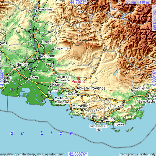
| \ | Map #1 | Map #2 | Topo.Map |
| Scale [m] | 174..373 m | 164..447 m | × |
| Scale [ft] | 571..1224 ft | 538..1467 ft | × |
| Average | 228.3 m = 749 ft | 251.3 m = 824 ft | × |
| Width | 7.07 km = 4.4 mi | 14.13 km = 8.8 mi | 226.1 km = 140.5 mi |
| Height | 7.07 km = 4.4 mi | 14.13 km = 8.8 mi | 226.1 km = 140.5 mi |
| ↑Max Latitude | 43.725916° | 43.757665° | 44.7023° |
| Latitude at center | 43.69415° | 43.69415° | 43.69415° |
| ↓Min Latitude | 43.662367° | 43.630568° | 42.66876° |
| ← Min Longitude | 5.458965° | 5.415019° | 4.09666° |
| Longitude center | 5.50291° | 5.50291° | 5.50291° |
| →Max Longitude | 5.546855° | 5.590801° | 6.90916° |
Nearby cities:
Cities around Pertuis sort by population:
• Venelles elevation 360 m
10.8 km,  189°
189°
• Le Puy-Sainte-Réparade 204 m
6.4 km,  238°
238°
• Rognes 316 m
13 km,  254°
254°
• Cadenet 208 m
11.4 km,  293°
293°
• Peyrolles-en-Provence 218 m
8.5 km,  129°
129°
• Jouques 310 m
12.5 km,  120°
120°
• Meyrargues 272 m
6.7 km,  163°
163°
• Villelaure 252 m
5.8 km, 288°
• Cucuron 352 m
10.2 km,  329°
329°
• Lourmarin 235 m
13.7 km,  304°
304°
• Grambois 366 m
10.2 km,  42°
42°
• Ansouis 265 m
5.8 km, 326°
Multilingual:
 En español:
Pertuis elevación 220 m.
 En France:
Pertuis élévation 220 m.


Sources and notes:
- [note 1] Map square and city borders are not equal. Map elevation data is calculated only from area inside that square.
- [src 1] Elevation data from geonames database provided with same terms of usage.
- [src 2] The elevation map of Pertuis is generated using elevation data from NASA's 3 arcsec (90m) resolution SRTM data.
- [src 3] Base (background) map © OpenStreetMap contributors tiles are generated by Geofabrik and OpenTopoMap.
Copyright & License:
This Pertuis Elevation Map is licensed under CC BY-SA. You may reuse any part from this page, if you give a proper credit by linking to this URL:
 More info on terms of use page.