Peyrolles-en-Provence elevation
Peyrolles-en-Provence (Provence-Alpes-Côte d'Azur, Département des Bouches-du-Rhône), France elevation is 218 meters and Peyrolles-en-Provence elevation in feet is 715 ft above sea level [src 1]. Peyrolles-en-Provence is a populated place (feature code) with elevation that is 44 meters (144 ft) bigger than average city elevation in France.
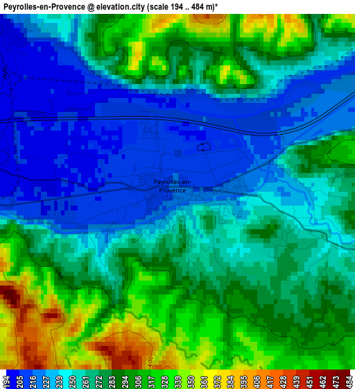
Below is the Elevation map of Peyrolles-en-Provence, which displays elevation range with different colors. Scale of the first map is from 194 to 484 m (636 to 1588 ft) with average elevation of 269.7 meters (=885 ft) [note 1]
These maps also provides idea of topography and contour of this city, they are displayed at different zoom levels. More info about maps, scale and edge coordinates you can find below images.
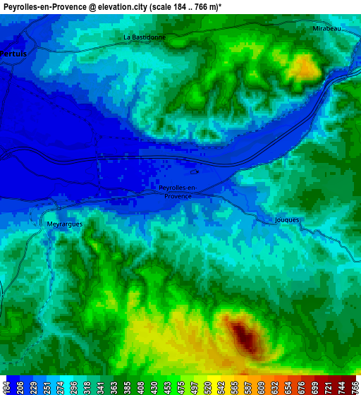
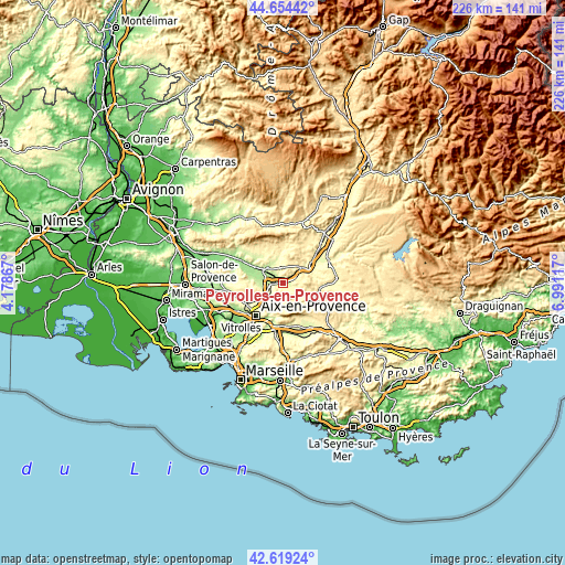
| \ | Map #1 | Map #2 | Topo.Map |
| Scale [m] | 194..484 m | 184..766 m | × |
| Scale [ft] | 636..1588 ft | 604..2513 ft | × |
| Average | 269.7 m = 885 ft | 324.4 m = 1064 ft | × |
| Width | 7.07 km = 4.4 mi | 14.14 km = 8.8 mi | 226.3 km = 140.6 mi |
| Height | 7.07 km = 4.4 mi | 14.14 km = 8.8 mi | 226.3 km = 140.6 mi |
| ↑Max Latitude | 43.677241° | 43.709016° | 44.65442° |
| Latitude at center | 43.64545° | 43.64545° | 43.64545° |
| ↓Min Latitude | 43.613642° | 43.581817° | 42.61924° |
| ← Min Longitude | 5.540975° | 5.497029° | 4.17867° |
| Longitude center | 5.58492° | 5.58492° | 5.58492° |
| →Max Longitude | 5.628865° | 5.672811° | 6.99117° |
Nearby cities:
Cities around Peyrolles-en-Provence sort by population:
• Pertuis elevation 220 m
8.5 km,  309°
309°
• Venelles 360 m
9.9 km,  238°
238°
• Le Puy-Sainte-Réparade 204 m
12.2 km,  279°
279°
• Rians 392 m
14.5 km,  107°
107°
• Jouques 310 m
4.3 km,  102°
102°
• Meyrargues 272 m
4.8 km,  258°
258°
• Villelaure 252 m
14.1 km,  300°
300°
• Le Tholonet 184 m
15 km,  203°
203°
• Grambois 366 m
13 km,  1°
1°
• Saint-Marc-Jaumegarde 380 m
12 km, 204°
• Ansouis 265 m
14.2 km,  316°
316°
• Beaumont-de-Pertuis 333 m
13.2 km,  39°
39°
Multilingual:
 En español:
Peyrolles-en-Provence elevación 218 m.
 En France:
Peyrolles-en-Provence élévation 218 m.
 Auf Deutsch:
Peyrolles-en-Provence höhe über dem Meeresspiegel ist 218 m.

Sources and notes:
- [note 1] Map square and city borders are not equal. Map elevation data is calculated only from area inside that square.
- [src 1] Elevation data from geonames database provided with same terms of usage.
- [src 2] The elevation map of Peyrolles-en-Provence is generated using elevation data from NASA's 3 arcsec (90m) resolution SRTM data.
- [src 3] Base (background) map © OpenStreetMap contributors tiles are generated by Geofabrik and OpenTopoMap.
Copyright & License:
This Peyrolles-en-Provence Elevation Map is licensed under CC BY-SA. You may reuse any part from this page, if you give a proper credit by linking to this URL:
 More info on terms of use page.