Pluguffan elevation
Pluguffan (Brittany, Département du Finistère), France elevation is 97 meters and Pluguffan elevation in feet is 318 ft above sea level [src 1]. Pluguffan is a populated place (feature code) with elevation that is 77 meters (253 ft) smaller than average city elevation in France.
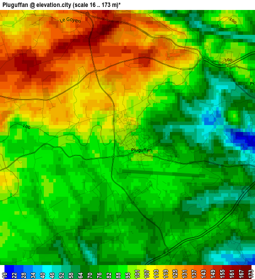
Below is the Elevation map of Pluguffan, which displays elevation range with different colors. Scale of the first map is from 16 to 173 m (52 to 568 ft) with average elevation of 93.6 meters (=307 ft) [note 1]
These maps also provides idea of topography and contour of this city, they are displayed at different zoom levels. More info about maps, scale and edge coordinates you can find below images.
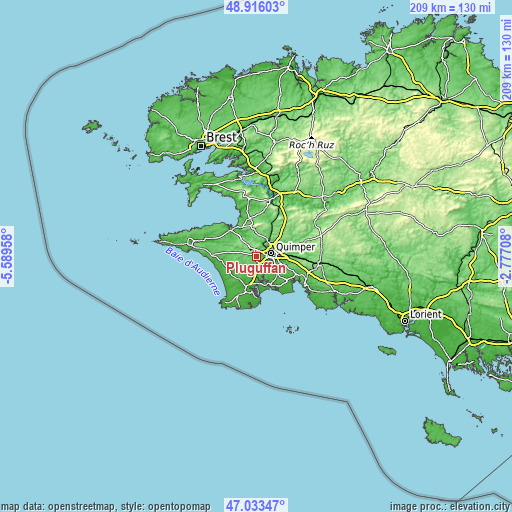
| \ | Map #1 | Topo.Map |
| Scale [m] | 16..173 m | × |
| Scale [ft] | 52..568 ft | × |
| Average | 93.6 m = 307 ft | × |
| Width | 6.54 km = 4.1 mi | 209.3 km = 130.1 mi |
| Height | 6.54 km = 4.1 mi | 209.3 km = 130.1 mi |
| ↑Max Latitude | 48.012736° | 48.91603° |
| Latitude at center | 47.98333° | 47.98333° |
| ↓Min Latitude | 47.953907° | 47.03347° |
| ← Min Longitude | -4.227275° | -5.58958° |
| Longitude center | -4.18333° | -4.18333° |
| →Max Longitude | -4.139385° | -2.77708° |
Nearby cities:
Cities around Pluguffan sort by population:
• Quimper elevation 36 m
6.5 km,  73°
73°
• Ergué-Gabéric 79 m
12.1 km,  83°
83°
• Plonéour-Lanvern 60 m
11.9 km,  218°
218°
• Plomelin 45 m
6.1 km,  155°
155°
• Combrit 33 m
10.8 km,  170°
170°
• Plogonnec 119 m
11.1 km,  0°
0°
• Gouesnach 40 m
9.6 km,  147°
147°
• Clohars-Fouesnant 39 m
13.1 km,  137°
137°
• Plogastel-Saint-Germain 81 m
6.2 km,  270°
270°
• Guengat 111 m
6.7 km,  346°
346°
• Plonéis 145 m
4.5 km,  326°
326°
• Landudec 121 m
11.5 km,  279°
279°
Multilingual:
 En español:
Pluguffan elevación 97 m.
 En France:
Pluguffan élévation 97 m.
 Auf Deutsch:
Pluguffan höhe über dem Meeresspiegel ist 97 m.

Sources and notes:
- [note 1] Map square and city borders are not equal. Map elevation data is calculated only from area inside that square.
- [src 1] Elevation data from geonames database provided with same terms of usage.
- [src 2] The elevation map of Pluguffan is generated using elevation data from NASA's 3 arcsec (90m) resolution SRTM data.
- [src 3] Base (background) map © OpenStreetMap contributors tiles are generated by Geofabrik and OpenTopoMap.
Copyright & License:
This Pluguffan Elevation Map is licensed under CC BY-SA. You may reuse any part from this page, if you give a proper credit by linking to this URL:
 More info on terms of use page.