Guengat elevation
Guengat (Brittany, Département du Finistère), France elevation is 111 meters and Guengat elevation in feet is 364 ft above sea level [src 1]. Guengat is a populated place (feature code) with elevation that is 63 meters (207 ft) smaller than average city elevation in France.
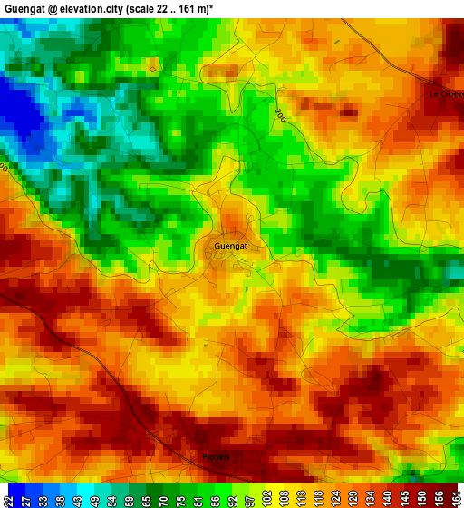
Below is the Elevation map of Guengat, which displays elevation range with different colors. Scale of the first map is from 22 to 161 m (72 to 528 ft) with average elevation of 107.9 meters (=354 ft) [note 1]
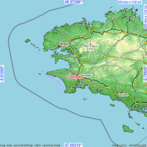
These maps also provides idea of topography and contour of this city, they are displayed at different zoom levels. More info about maps, scale and edge coordinates you can find below images.
| \ | Map #1 | Topo.Map |
| Scale [m] | 22..161 m | × |
| Scale [ft] | 72..528 ft | × |
| Average | 107.9 m = 354 ft | × |
| Width | 6.53 km = 4.1 mi | 209.1 km = 129.9 mi |
| Height | 6.53 km = 4.1 mi | 209.1 km = 129.9 mi |
| ↑Max Latitude | 48.071303° | 48.97356° |
| Latitude at center | 48.04193° | 48.04193° |
| ↓Min Latitude | 48.01254° | 47.09314° |
| ← Min Longitude | -4.248645° | -5.61095° |
| Longitude center | -4.2047° | -4.2047° |
| →Max Longitude | -4.160755° | -2.79845° |
Nearby cities:
Cities around Guengat sort by population:
• Quimper elevation 36 m
9.1 km,  120°
120°
• Douarnenez 23 m
11 km,  302°
302°
• Plomelin 45 m
12.7 km,  161°
161°
• Pluguffan 97 m
6.7 km,  166°
166°
• Plogonnec 119 m
4.9 km,  19°
19°
• Plogastel-Saint-Germain 81 m
8 km,  215°
215°
• Plonévez-Porzay 124 m
6.5 km,  352°
352°
• Landrévarzec 97 m
12.1 km,  62°
62°
• Plonéis 145 m
2.9 km,  197°
197°
• Pouldergat 54 m
9.6 km,  275°
275°
• Landudec 121 m
10.9 km,  244°
244°
• Quéménéven 87 m
10.6 km,  38°
38°
Multilingual:
 En español:
Guengat elevación 111 m.
 En France:
Guengat élévation 111 m.


Sources and notes:
- [note 1] Map square and city borders are not equal. Map elevation data is calculated only from area inside that square.
- [src 1] Elevation data from geonames database provided with same terms of usage.
- [src 2] The elevation map of Guengat is generated using elevation data from NASA's 3 arcsec (90m) resolution SRTM data.
- [src 3] Base (background) map © OpenStreetMap contributors tiles are generated by Geofabrik and OpenTopoMap.
Copyright & License:
This Guengat Elevation Map is licensed under CC BY-SA. You may reuse any part from this page, if you give a proper credit by linking to this URL:
 More info on terms of use page.