Pontarlier elevation
Pontarlier (Bourgogne-Franche-Comté, Doubs), France elevation is 834 meters and Pontarlier elevation in feet is 2736 ft above sea level [src 1]. Pontarlier is a seat of a third-order administrative division (feature code) with elevation that is 660 meters (2165 ft) bigger than average city elevation in France.
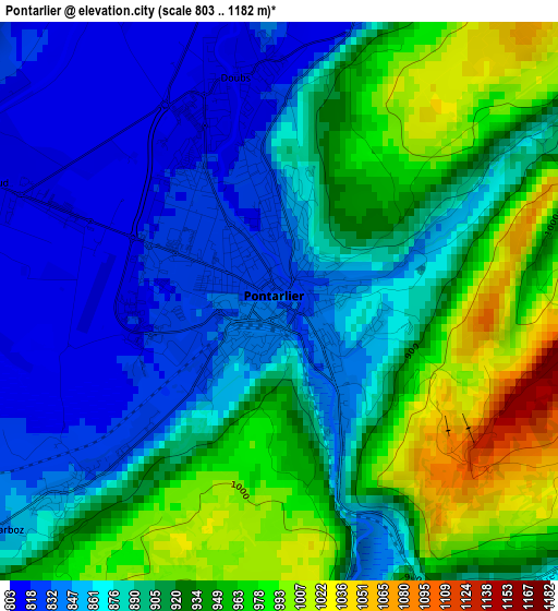
Below is the Elevation map of Pontarlier, which displays elevation range with different colors. Scale of the first map is from 803 to 1182 m (2635 to 3878 ft) with average elevation of 904.3 meters (=2967 ft) [note 1]
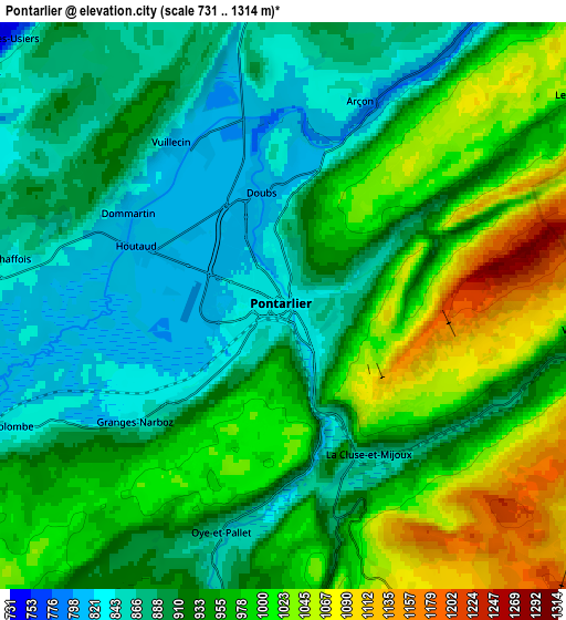
These maps also provides idea of topography and contour of this city, they are displayed at different zoom levels. More info about maps, scale and edge coordinates you can find below images.
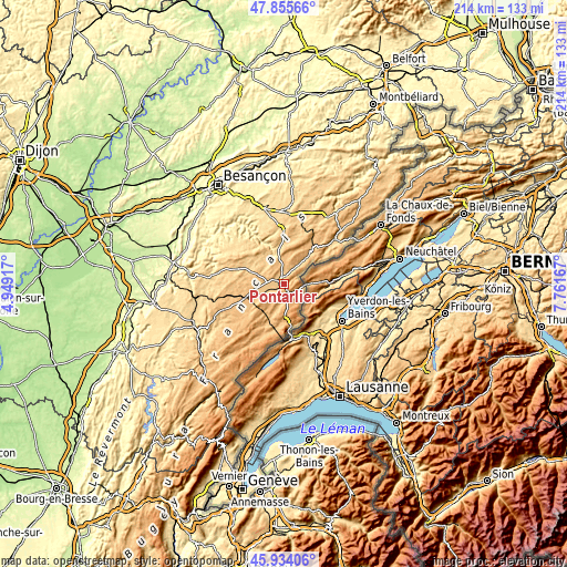
| \ | Map #1 | Map #2 | Topo.Map |
| Scale [m] | 803..1182 m | 731..1314 m | × |
| Scale [ft] | 2635..3878 ft | 2398..4311 ft | × |
| Average | 904.3 m = 2967 ft | 939.1 m = 3081 ft | × |
| Width | 6.68 km = 4.2 mi | 13.35 km = 8.3 mi | 213.7 km = 132.8 mi |
| Height | 6.68 km = 4.2 mi | 13.35 km = 8.3 mi | 213.6 km = 132.7 mi |
| ↑Max Latitude | 46.933486° | 46.963486° | 47.85566° |
| Latitude at center | 46.90347° | 46.90347° | 46.90347° |
| ↓Min Latitude | 46.873437° | 46.843387° | 45.93406° |
| ← Min Longitude | 6.311475° | 6.267529° | 4.94917° |
| Longitude center | 6.35542° | 6.35542° | 6.35542° |
| →Max Longitude | 6.399365° | 6.443311° | 7.76167° |
Nearby cities:
Cities around Pontarlier sort by population:
• Morteau elevation 769 m
25.7 km,  48°
48°
• Valdahon 664 m
27.4 km,  359°
359°
• Ornans 337 m
27.8 km,  324°
324°
• Doubs 810 m
2.7 km,  353°
353°
• Levier 716 m
18.7 km,  287°
287°
• Montlebon 803 m
24.5 km, 52°
• Frasne 856 m
15.8 km,  250°
250°
• Gilley 885 m
18.7 km,  31°
31°
• Jougne 993 m
15.8 km,  170°
170°
• La Cluse-et-Mijoux 1090 m
3.1 km,  136°
136°
• Les Fourgs 1089 m
8.4 km,  156°
156°
• Étalans 596 m
28.2 km, 347°
Multilingual:
 En español:
Pontarlier elevación 834 m.
 En France:
Pontarlier élévation 834 m.
 Auf Deutsch:
Pontarlier höhe über dem Meeresspiegel ist 834 m.

Sources and notes:
- [note 1] Map square and city borders are not equal. Map elevation data is calculated only from area inside that square.
- [src 1] Elevation data from geonames database provided with same terms of usage.
- [src 2] The elevation map of Pontarlier is generated using elevation data from NASA's 3 arcsec (90m) resolution SRTM data.
- [src 3] Base (background) map © OpenStreetMap contributors tiles are generated by Geofabrik and OpenTopoMap.
Copyright & License:
This Pontarlier Elevation Map is licensed under CC BY-SA. You may reuse any part from this page, if you give a proper credit by linking to this URL:
 More info on terms of use page.