Rennes elevation
Rennes (Brittany, Département d'Ille-et-Vilaine), France elevation is 39 meters and Rennes elevation in feet is 128 ft above sea level [src 1]. Rennes is a seat of a first-order administrative division (feature code) with elevation that is 135 meters (443 ft) smaller than average city elevation in France.
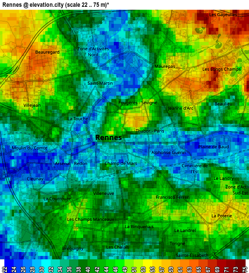
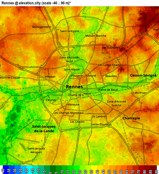
Below is the Elevation map of Rennes, which displays elevation range with different colors. Scale of the first map is from 22 to 75 m (72 to 246 ft) with average elevation of 41.5 meters (=136 ft) [note 1]
These maps also provides idea of topography and contour of this city, they are displayed at different zoom levels. More info about maps, scale and edge coordinates you can find below images.
| \ | Map #1 | Map #2 | Topo.Map |
| Scale [m] | 22..75 m | -40..90 m | × |
| Scale [ft] | 72..246 ft | -131..295 ft | × |
| Average | 41.5 m = 136 ft | 43.2 m = 142 ft | × |
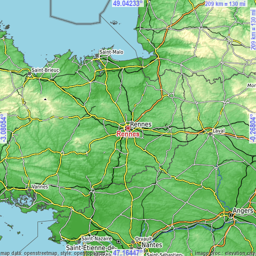
| Width | 6.52 km = 4.1 mi | 13.05 km = 8.1 mi | 208.8 km = 129.7 mi |
| Height | 6.52 km = 4.1 mi | 13.05 km = 8.1 mi | 208.8 km = 129.7 mi |
| ↑Max Latitude | 48.141313° | 48.170629° | 49.04233° |
| Latitude at center | 48.11198° | 48.11198° | 48.11198° |
| ↓Min Latitude | 48.08263° | 48.053264° | 47.16447° |
| ← Min Longitude | -1.718235° | -1.762181° | -3.08054° |
| Longitude center | -1.67429° | -1.67429° | -1.67429° |
| →Max Longitude | -1.630345° | -1.586399° | -0.26804° |
Nearby cities:
Cities around Rennes sort by population:
• Cesson-Sévigné elevation 37 m
5.4 km,  79°
79°
• Betton 37 m
8.1 km,  19°
19°
• Pacé 53 m
8.4 km,  298°
298°
• Saint-Jacques-de-la-Lande 38 m
6.3 km,  213°
213°
• Saint-Grégoire 44 m
4.4 km,  347°
347°
• Chantepie 52 m
5.1 km,  120°
120°
• Chartres-de-Bretagne 32 m
8.4 km,  195°
195°
• Fouillard 80 m
8.7 km,  53°
53°
• Châtillon-sur-Seiche 23 m
8.6 km,  178°
178°
• Vezin-le-Coquet 50 m
6 km,  277°
277°
• La Chapelle-des-Fougeretz 86 m
8.4 km,  329°
329°
• Montgermont 54 m
5.7 km, 328°
Multilingual:
 En español:
Rennes elevación 39 m.
 En France:
Rennes élévation 39 m.


Sources and notes:
- [note 1] Map square and city borders are not equal. Map elevation data is calculated only from area inside that square.
- [src 1] Elevation data from geonames database provided with same terms of usage.
- [src 2] The elevation map of Rennes is generated using elevation data from NASA's 3 arcsec (90m) resolution SRTM data.
- [src 3] Base (background) map © OpenStreetMap contributors tiles are generated by Geofabrik and OpenTopoMap.
Copyright & License:
This Rennes Elevation Map is licensed under CC BY-SA. You may reuse any part from this page, if you give a proper credit by linking to this URL:
 More info on terms of use page.