Chantepie elevation
Chantepie (Brittany, Département d'Ille-et-Vilaine), France elevation is 52 meters and Chantepie elevation in feet is 171 ft above sea level [src 1]. Chantepie is a populated place (feature code) with elevation that is 122 meters (400 ft) smaller than average city elevation in France.
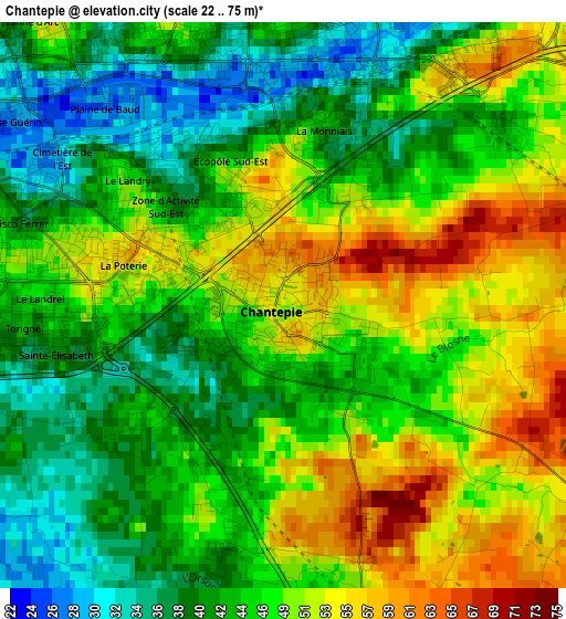
Below is the Elevation map of Chantepie, which displays elevation range with different colors. Scale of the first map is from 22 to 75 m (72 to 246 ft) with average elevation of 46.4 meters (=152 ft) [note 1]
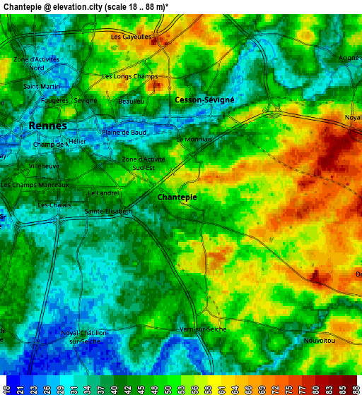
These maps also provides idea of topography and contour of this city, they are displayed at different zoom levels. More info about maps, scale and edge coordinates you can find below images.
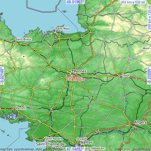
| \ | Map #1 | Map #2 | Topo.Map |
| Scale [m] | 22..75 m | 18..88 m | × |
| Scale [ft] | 72..246 ft | 59..289 ft | × |
| Average | 46.4 m = 152 ft | 46.3 m = 152 ft | × |
| Width | 6.53 km = 4.1 mi | 13.06 km = 8.1 mi | 208.9 km = 129.8 mi |
| Height | 6.53 km = 4.1 mi | 13.06 km = 8.1 mi | 208.9 km = 129.8 mi |
| ↑Max Latitude | 48.118196° | 48.147525° | 49.01963° |
| Latitude at center | 48.08885° | 48.08885° | 48.08885° |
| ↓Min Latitude | 48.059487° | 48.030108° | 47.14092° |
| ← Min Longitude | -1.659185° | -1.703131° | -3.02149° |
| Longitude center | -1.61524° | -1.61524° | -1.61524° |
| →Max Longitude | -1.571295° | -1.527349° | -0.20899° |
Nearby cities:
Cities around Chantepie sort by population:
• Rennes elevation 39 m
5.1 km,  300°
300°
• Cesson-Sévigné 37 m
3.7 km,  14°
14°
• Saint-Jacques-de-la-Lande 38 m
8.3 km,  251°
251°
• Vern-sur-Seiche 50 m
5 km,  167°
167°
• Chartres-de-Bretagne 32 m
8.7 km,  230°
230°
• Fouillard 80 m
8.2 km,  19°
19°
• Châtillon-sur-Seiche 23 m
7.3 km,  214°
214°
• Acigné 45 m
7.6 km,  49°
49°
• Noyal-sur-Vilaine 77 m
7.3 km,  69°
69°
• Nouvoitou 56 m
7.3 km,  136°
136°
• Saint-Erblon 37 m
8.2 km,  199°
199°
• Saint-Armel 37 m
8.6 km, 168°
Multilingual:
 En español:
Chantepie elevación 52 m.
 En France:
Chantepie élévation 52 m.
 Auf Deutsch:
Chantepie höhe über dem Meeresspiegel ist 52 m.

Sources and notes:
- [note 1] Map square and city borders are not equal. Map elevation data is calculated only from area inside that square.
- [src 1] Elevation data from geonames database provided with same terms of usage.
- [src 2] The elevation map of Chantepie is generated using elevation data from NASA's 3 arcsec (90m) resolution SRTM data.
- [src 3] Base (background) map © OpenStreetMap contributors tiles are generated by Geofabrik and OpenTopoMap.
Copyright & License:
This Chantepie Elevation Map is licensed under CC BY-SA. You may reuse any part from this page, if you give a proper credit by linking to this URL:
 More info on terms of use page.