Vezin-le-Coquet elevation
Vezin-le-Coquet (Brittany, Département d'Ille-et-Vilaine), France elevation is 50 meters and Vezin-le-Coquet elevation in feet is 164 ft above sea level [src 1]. Vezin-le-Coquet is a populated place (feature code) with elevation that is 124 meters (407 ft) smaller than average city elevation in France.
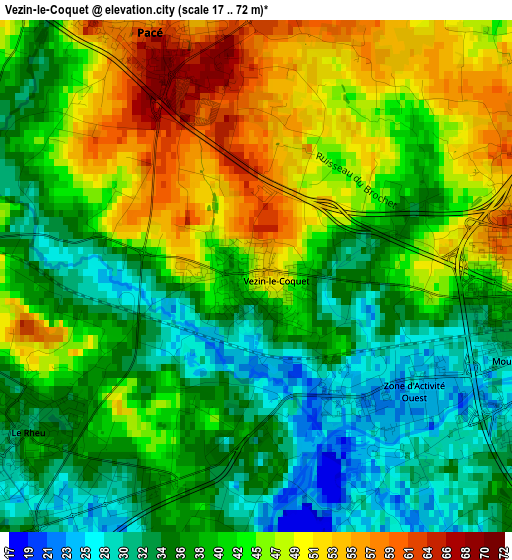
Below is the Elevation map of Vezin-le-Coquet, which displays elevation range with different colors. Scale of the first map is from 17 to 72 m (56 to 236 ft) with average elevation of 41.1 meters (=135 ft) [note 1]
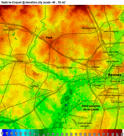
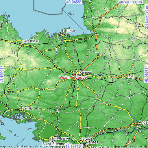
These maps also provides idea of topography and contour of this city, they are displayed at different zoom levels. More info about maps, scale and edge coordinates you can find below images.
| \ | Map #1 | Map #2 | Topo.Map |
| Scale [m] | 17..72 m | -40..92 m | × |
| Scale [ft] | 56..236 ft | -131..302 ft | × |
| Average | 41.1 m = 135 ft | 41.7 m = 137 ft | × |
| Width | 6.52 km = 4.1 mi | 13.05 km = 8.1 mi | 208.8 km = 129.7 mi |
| Height | 6.52 km = 4.1 mi | 13.05 km = 8.1 mi | 208.8 km = 129.7 mi |
| ↑Max Latitude | 48.147899° | 48.177212° | 49.0488° |
| Latitude at center | 48.11857° | 48.11857° | 48.11857° |
| ↓Min Latitude | 48.089224° | 48.059861° | 47.17118° |
| ← Min Longitude | -1.798605° | -1.842551° | -3.16091° |
| Longitude center | -1.75466° | -1.75466° | -1.75466° |
| →Max Longitude | -1.710715° | -1.666769° | -0.34841° |
Nearby cities:
Cities around Vezin-le-Coquet sort by population:
• Rennes elevation 39 m
6 km,  97°
97°
• Pacé 53 m
3.6 km,  337°
337°
• Saint-Jacques-de-la-Lande 38 m
6.4 km,  157°
157°
• Saint-Grégoire 44 m
6.2 km,  54°
54°
• Le Rheu 36 m
3.6 km,  240°
240°
• Mordelles 34 m
8.1 km,  233°
233°
• Saint-Gilles 52 m
6.5 km,  306°
306°
• La Chapelle-des-Fougeretz 86 m
6.7 km,  14°
14°
• Chavagne 32 m
7.5 km,  197°
197°
• Montgermont 54 m
5.1 km,  35°
35°
• La Chapelle-Thouarault 50 m
8.3 km,  274°
274°
• Cintré 39 m
8.8 km,  260°
260°
Multilingual:
 En español:
Vezin-le-Coquet elevación 50 m.
 En France:
Vezin-le-Coquet élévation 50 m.
 Auf Deutsch:
Vezin-le-Coquet höhe über dem Meeresspiegel ist 50 m.

Sources and notes:
- [note 1] Map square and city borders are not equal. Map elevation data is calculated only from area inside that square.
- [src 1] Elevation data from geonames database provided with same terms of usage.
- [src 2] The elevation map of Vezin-le-Coquet is generated using elevation data from NASA's 3 arcsec (90m) resolution SRTM data.
- [src 3] Base (background) map © OpenStreetMap contributors tiles are generated by Geofabrik and OpenTopoMap.
Copyright & License:
This Vezin-le-Coquet Elevation Map is licensed under CC BY-SA. You may reuse any part from this page, if you give a proper credit by linking to this URL:
 More info on terms of use page.